
It seems like winter has really gotten its act together over the last 2 weeks as most now sit with above average snow and near normal January temps. I am now tracking a storm that threatens to bring parts of the Mid-Atlantic a decent snow. However, we're not included in those getting a decent snow, but the timing of when we get our snow could be worrisome. Over the past few days our models have really come into agreement, for the most part, on how the storm will evolve. It currently appears that we'll have an area of low pressure move out of the Ohio Valley and right through the Mid-Atlantic overnight into tomorrow morning. As that happens, we should see mainly rain showers with a few areas northwest of DC having their rain showers mixing with some snowflakes that could accumulate. Our rain would have the best chance to mix in and/or switch over snow for a brief time tomorrow morning before switching back over to rain Tomorrow, our low pressure redevelops as a coastal low, that will track up the coast. As this happens, we switch back to rain after any snow in the morning and we will stay that way throughout the day Tuesday. As cold air comes in, we may switch back to snow overnight Tuesday into early Wednesday morning before any precip ends. Basically, we have to chances of snow in this storm: tonight and tomorrow night. This set up where we are dealing with two lows is referred to as a "Miller B" set up. A Miller B setup is never friendly to Southern Maryland snow lovers. Temperatures, as is normally the case, are concerning to me as a snow lover. I don't think we fall below freezing until Tuesday night. Temperatures will only be marginally okay for snow tonight. The further north you are, better the chance of seeing snow, further south the opposite is true. 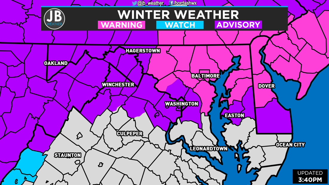 Monday afternoon Weather Alerts that have been hoisted for portions of the Mid-Atlantic. The National Weather Service has posted Winter Storm Warnings for the counties where the highest snowfall accumulations are likely to be. In Southern MD, Anne Arundel is included, but if you're south of Route 50, don't expect to see too much, that warning is more so for the northern end. Winter Weather Advisories are posted in locations where at least 2" of snow is possible, and PG County is included. No "core SoMD counties" are included because we likely won't meet that 2" requirement.
While we won't see a lot of snow, generally under an inch, and any snow that falls would do snow right before the Tuesday AM Rush (may linger into the Rush) and again before the Wednesday AM Rush. Because of that, school systems, especially northern ones, may want to delay to allow for any slush of icy spots to clear. If the snow falls longer and can accumulate more, the snow may last long enough in the morning to make any travel before 10am unsafe, which could lead to a close. This is true for not only Tuesday morning, but Wednesday morning as well.  The Bottom Line is that this will not be a big snow event. Most of Southern MD will see snow totals under an inch as most of this event is rain. Any snow that falls would do so before the Tuesday AM Rush and the Wednesday AM Rush. It is because of that timing that schools may need to delay or close. It's not amounts, it's timing. I'm more confident in this forecast than I was for Friday's snow event, but a few things could still change. Stay with JB Weather for the latest information.
Lead Forecaster -John Bordash
1 Comment
 Next Chance of Accumulating Snow: Monday Night - Tuesday
Probability of Accumulating Snow (1" or more): 30% Winter made it's presence felt across the area this morning as a weak coastal system changed last night's rain over to a mix of snow and sleet. We didn't have enough frozen precipitation to cause major issues, but it was enough be a nuisance. Our forecast of a slushy coating to 2" verified nicely across the region. Now all eyes turn to the potential winter storm threat for early next week. At this point, we're still three to four days out from this storm, so a lot of details are unknown. I'll be gone Saturday and Sunday, which means no posts from me just limited ones from Daniel. Thus, I just wanted to give our followers a heads up with my latest thoughts before leaving. A storm on Sunday will be sliding well to our south, and give portions of the Carolinas some rain showers. We should remain dry this weekend. If that system track a little bit further northwest, we could have some rain showers on the Eastern Shore on Sunday, but it would take a drastic change to get any precip back to Southern Maryland. Right now, it appears that an area of low pressure will track from the Ohio Valley and across our region before developing a new low off the coast and tracks up the coast. I've seen this set up before, and it is one that tends not to work in our favor for snow lovers in SoMD. My forecast's have busted before when we have this set up, so I'll keep my forecast a bit more "conservative" or warmer at this point. As things stand 4 days out, it looks like we will have rain showers develop Monday evening with temperatures in the 40s, with the chance of some sleet and snow mixing in NW of I95. As the new low forms Monday night into Tuesday, it will try to bring down colder air and attempt to switch us over to snow, and any precip would be down with by Tuesday afternoon. Again, I don't want to get too specific this far out because so much can change. I wouldn't expect more than a couple of inches for us, but even that is just speculation at this point. ANd before anyone asks, way too early for School Odds. Stay with JB Weather this weekend as Daniel will have posts and updates on this storm. I'll be back Sunday afternoon with an updated forecast. Enjoy the nice weather this weekend and root for the Carolina Panthers to bring home a Super Bowl Ring ;). Lead Forecaster -John Bordash 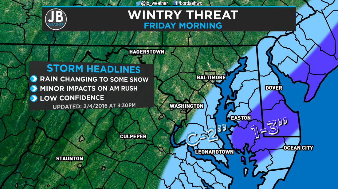 The C-2 means a Coating to 2". I just ran out of room for the whole word. The forecast for tonight and tomorrow morning is not an easy one at all. The setup we have is marginal at best for accumulating snow, but the question is if the odds will work in our favor. I've seen setups similar to this before, and each time they it has been a tricky forecast. There is the potential for some good snows, but the bust potential is high. For a quick overview, scroll down to the "The Bottom Line" paragraph. The Setup we have going into tonight is marginal. We have the cold front that moved through yesterday sitting just off the coastline, with moisture streaming along it from the Gulf of Mexico. A weak area of low pressure will form along it, and run up the coast. The biggest question with this forecast is how close to the coast does it come? It's proximity to the coast will affect not only the amount of precipitation that gets thrown back to the coast, but how cold we are able to get. We have two scenarios for this storm. In Scenario 1 the storm is further out to sea, which would allow temperatures to fall between 30-34 with little to no precipitation. Our second scenario is that the storm moves closer to the coast which wouldn't allow temps to fall as low, only between 32 and 36, but we'd see more precip that could be heavy and may be able to overcome the temps. The "bust" potential comes in play more so with the second scenario. If the precip is not heavy enough, it will not be able to overcome the temps, and would be mainly rain. Today our weather models were showing a solution more like the second scenario, and based off Radar and Satellite today, I agree. Now the question is: will the precip be able to overcome the marginal temps and switch over to snow? My thinking is that it may take a while at first, but we will eventually switch over to snow. My biggest issue that I see with accumulating snow is that we have been warm the past few days, thus the ground temps are warm and road temps are even warmer. I expect any snow that falls to accumulate on grassy/shaded areas, on car tops, and maybe on your deck. If the snow falls heavy enough, there might some areas of slush on the roads. However, the bust potential would be that we are looking at no accumulation. 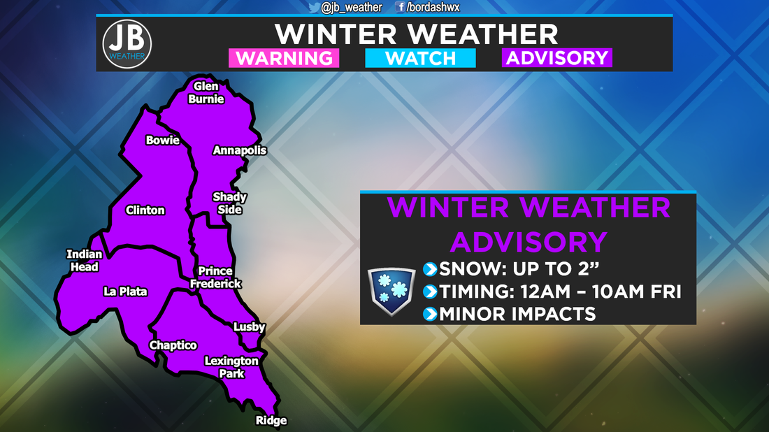 As you can see above, the National Weather Service has gone ahead and issued a Winter Weather Advisory for Southern Maryland. The further south and east you head, higher the chance of accumulating snow. The Impacts from this storm will not be high. The reason why this could be somewhat troublesome is the timing. Rain would transition over from snow between midnight and 3am, and any snow would be done by about 8 or 9am. There would be some impacts on the morning commute. How will this affect schools? If things unfold the way my forecast says, I could see delays for Calvert and St. Mary's. If the system moves further east, I could see delays for the other counties too. If any snow lasts longer, there may be some closings. But remember, the bust potential, in which we see just rain, would mean on time openings, hence why these numbers are low. 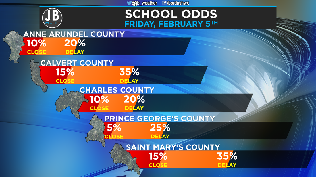  The Bottom Line is that snow is possible tomorrow morning. Temperatures will only be marginal for snow to fall and accumulate, so there is a high bust potential. It's for that reason that is a low confidence forecast. The further south and east you live, higher the chance for snow. Southern St. Mary's may end up with the highest totals for our region. There could be minor impacts tomorrow for the AM Rush. School delays are possible in Calvert & St. Mary's. I will start continuous coverage tomorrow morning at 4am to cover any delays & impacts to your morning commute. Stay with JB Weather for the latest on SoMD weather.
Lead Forecaster -John Bordash 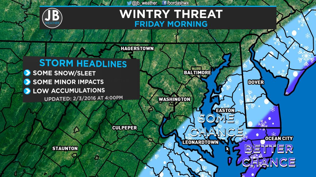 Chances of seeing snow/sleet Friday Morning. A cold front is moving through the region tonight, hence the rain, and will bring cooler temps late this week and weekend with temps maxing out in the 40s. The front will stall just off the East Coast and a weak area of low pressure will develop. As this weak storm heads north, it could try to push precip back to the coastline, which would fall as snow or sleet with temps in the low 30s. The question remains, though: How far west will this storm come, and thus how much precipitation will make it to the coast? 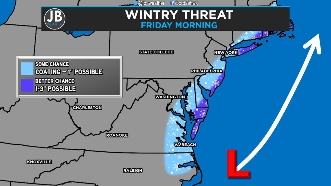 Overall set up Friday Morning and a guess at possible accumulations along the East Coast. Today's afternoon model runs moved a little west with the storm's precipitation shield. The result is that our models pretty much have Southern Maryland seeing some light, accumulating snow between 3am and 9am Friday morning. Verbatim, some areas on the Eastern Shore would see a couple of inches, while other areas closer to I-95, could get just flurries or no snow at all. Will that scenario play out? Potentially, but storms like these have busted before, so you must take all of this with a grain of salt, and I am a little skeptical about this.  The Bottom Line is that some light snow is possible right now Friday Morning. If I had to throw a number on it, I'd say about a 40% chance. Any snow would fall between 3am and 9am, and that would spell some trouble for the morning commute, but nothing too major. Before anyone asks, it's too early to even speculate on School Odds for Friday. If this threat is legitimate, then expect School Odds tomorrow. A coating to an inch is possible. However, I'll update that, and do an actual forecast map, tomorrow afternoon if conditions warrant.
Stay tuned to JB Weather for the latest on Southern Maryland weather. Lead Forecaster -John Bordash |
Archives
August 2020
Categories
All
|

 RSS Feed
