
|
10. Tropical Storm Lee Flooding (Sept. 2011) 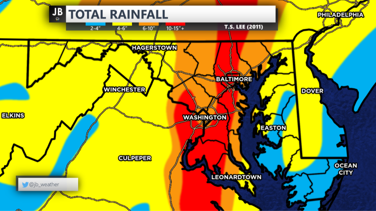 The Fall of 2011 was a very wet one. This is highlighted by the remnants of Tropical Storm Lee. After the weak tropical system made landfall along the Gulf Coast, the storm moved inland, towards the Plains. However, the storm got "stuck" as atmospheric blocking prevented the storm from moving much. The results was an onslaught of moisture that got spread across the Mid-Atlantic and Ohio River Valley. While our region saw more than half a foot of rain, Charles County was hit especially hard. A widespread 10-15" of rain fell across the county, with areas near Allens Fresh recording over 15". Additionally, a couple of quick spin-up tornadoes formed throughout the region, sending school systems in a frenzy. 9. Record Setting Heat Throughout the 2010s 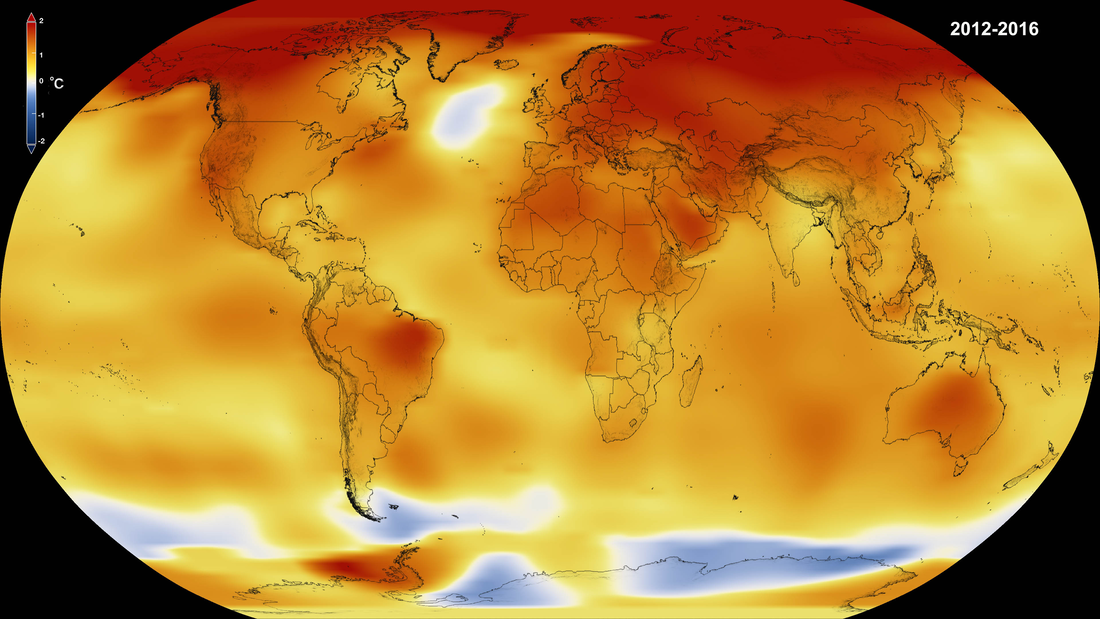 The 2010s will be remembered for a few things in the meteorological world. "Hot" will definitely be one of the words used when talking about the decade. The summers of the decade each seemed to get hotter, with more and more record highs getting set each year. 2010 saw the highest numbers of 90° days in modern history for the DC area, with 67 days reaching 90° or above. The intense heat was also felt during the summers of 2011 and 2012. In 2012, DC reached 100° or better 8 days. 8. Snowquester (Mar. 6, 2013) 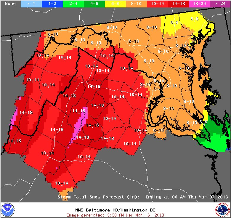 Snowquester makes it in to the Top 10 largely for what it didn't do. The Winter of 2012-13 was a snowless one for DC. Up until March, DC had failed to record 1" from any one storm. However, an impending storm in the beginning of March had looked to change that. In the midst of the Sequester crisis on Capitol Hill, this storm took on a similar name as it was expected to have big impacts. 8-12" of snow was forecasted for the region-- essentially a season's worth of snow. However, this forecast went horribly wrong. With warmer temperatures, and strong onshore flow, DC's Reagan National only recorded 0.2" of snow from the storm. This forecast was one of the worst forecasted storms in recent history, and not one that many local forecasters will forget. 7. Hurricane Sandy (Oct. 28-30, 2012) 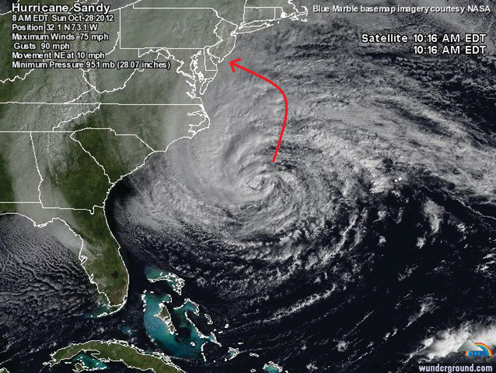 Thus far, the "Storm of the Century" has been Hurricane Sandy (albeit that might change seeing as we still have 80 years left in the century). This storm was quite abnormal. While moving out to sea, this storm took an unprecedented left turn right into the Jersey Shore. Widespread devastation was felt up and down the Northeast and Mid-Atlantic coastlines. The hurricane merged with a winter-like upper level low as it moved on shore causing an all out blizzard in the Mountains of MD, WV, and PA. If we were in New Jersey, this storm would easily have been the biggest weather story of the decade. However, impacts were not as serious here in SoMd like we had seen from prior storms. Nevertheless, do to the damage we did see, schools were closed for 2-3 days as the clean-up process began. 6. The Polar Vortex (Jan. 2014 & Feb. 2015) 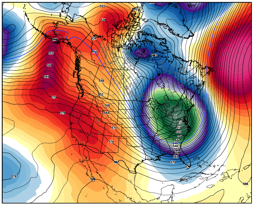 While the term "Polar Vortex" has been around for centuries, the term became big during the Winters of 2014 and 2015. During the latter half of these winters, a piece of Polar Vortex, from the Arctic North, got displaced. The displacement in the upper most levels of the atmosphere headed south, towards the Mid-Atlantic. During these two Polar Vortex outbreaks, temperatures plunged into the single digits and sub-zero for some. These bitterly cold outbreaks were enough to close area schools. 5. 2018 Record Setting Rain 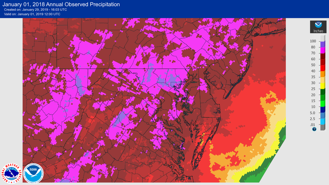 I'm sure many of you remember that it just did not seem to stop raining during 2018. It seemed like every couple of days, sometimes every day in the Summer, it was raining. The rain events were experienced were not just small events. Often times we would see 1-2" of rain a day. Local records were set as this was the wettest year on record. Many communities also saw devastating floods. This was the most evident for the communities in Northern Calvert County during the summer. 4. Hurricane Irene (Aug. 27-29, 2011) 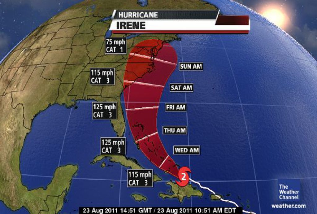 Hurricane Irene was the first hurricane many in our region had to deal with since Hurricane Isabel in 2003. The storm raced along the Bahama Island chain as a major hurricane. Many feared that the storm would maintain that strong intensity as it moved along the East Coast into New England. Thankfully, the storm did weaken as it moved northward. Nevertheless, our region in SoMd saw widespread damage as Hurricane Warnings were in effect. Many lost power for days, and area schools were closed for 3-5 days. 3. The Blizzard of 2016 (Jan. 22-23, 2016) 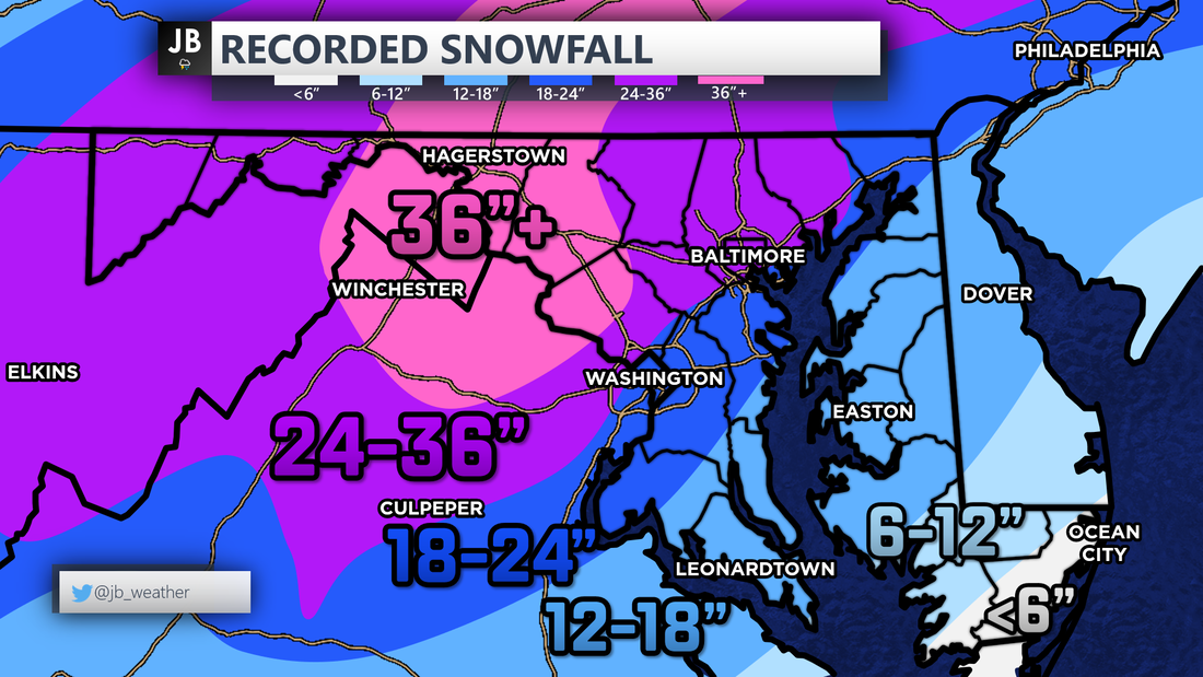 The Blizzard of 2016 came in what was otherwise a quiet year for snow lovers. Of the 22" of snow that fell in DC that winter, 17.8" came from this one storm. This storm was well forecasted a week out. Many in the Mid-Atlantic, from DC to New York, saw 1-2 feet of snow, with some areas in MD and PA seeing 3-4 feet of snow! Impacts were only moderate as the snow fell over the weekend. This was not a heavy wet snow, which made clean up easier. Nevertheless, area schools and the government were closed for the days following the storm. This storm sits as Baltimore's biggest ever with 29". 2. The Derecho (Jun. 29, 2012) 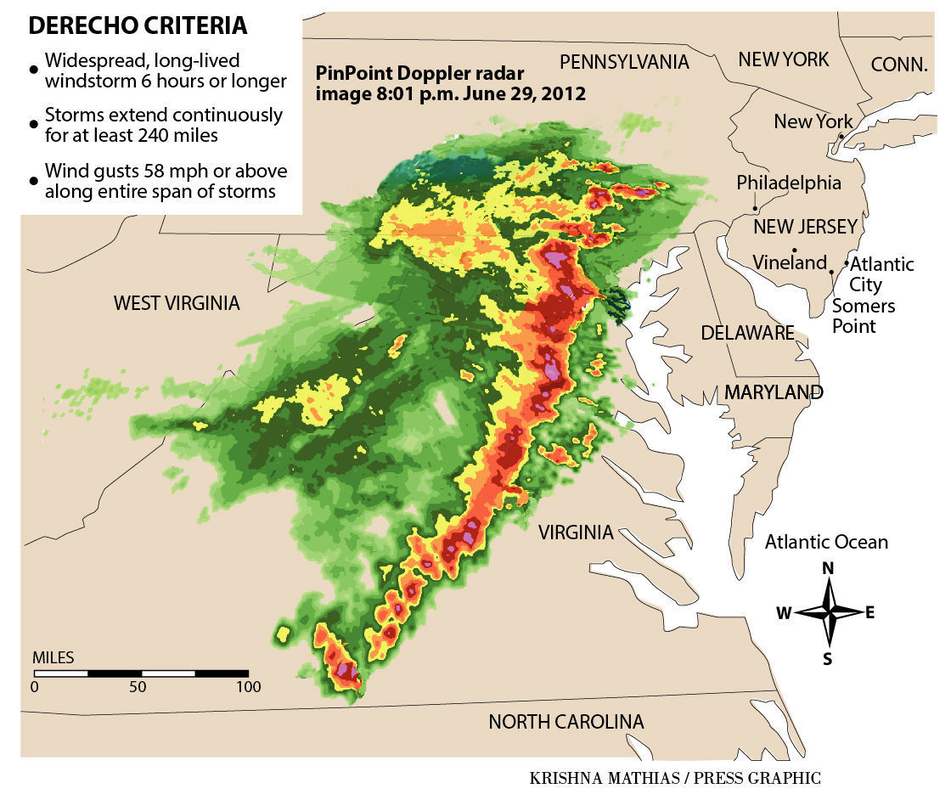 Say the word, "Derecho," to anyone in the DMV and they will have flashbacks to the 2012 Derecho. After hitting 104° that afternoon, a strong line of storms developed near Chicago, and raced towards our region. This quick and powerful line of storms left more than a million people without power across the DMV, which was in the midst of a heatwave. This line of storms packed 80-90mph winds, frequent lightning, and hail. Damage was widespread across the state. Power was not restored to some for about a week. 1. Snowmageddon (Feb. 5-6, 2010) 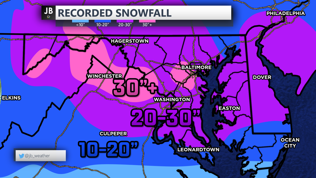 Finally, the biggest story of the decade-- Snowmaggendon. The Winter of 2009-2010 was a record setting one. Over 50" of snow fell in DC as 3 large-scale blizzards hit the region, along with a few other large 8-12" events. Getting just one blizzard for our area is hard, let alone three. What's more is that two of those blizzards happened within a week of each other. The first blizzard was in December of 2009, we then saw a 12"+ snowstorm (not a blizzard) hit SoMd at the end of January, then the blizzards in February. After this winter, area Superintendents were left applying for snow day vouchers as area schools were closed 10-20 days that winter. The biggest of the three blizzards was the February 5-6 storm. This storm dropped 20-30" of snow widespread across the area-- even in SoMd. With the rain/snow line suppressed well to the south, SoMd cashed in on the snow totals. The heavy, wet snow took a long time to clear. I was in 8th grade when this storm hit our region, and really perked my interest in the weather. I remember being out of school for a week and half from this storm. This blizzard, and this winter in whole, will be one that lives on for a long time in the history books!
0 Comments
|
Archives
August 2020
Categories
All
|
 RSS Feed
