
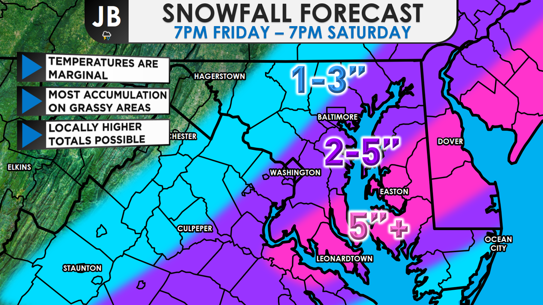
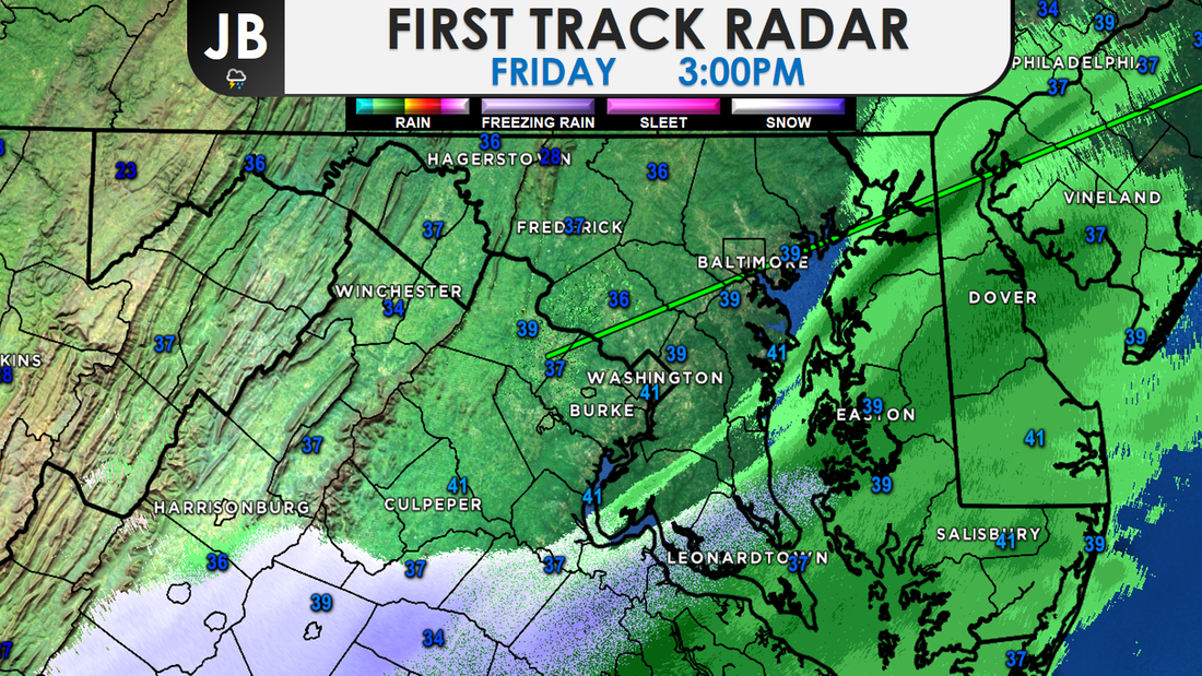
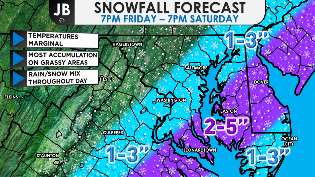
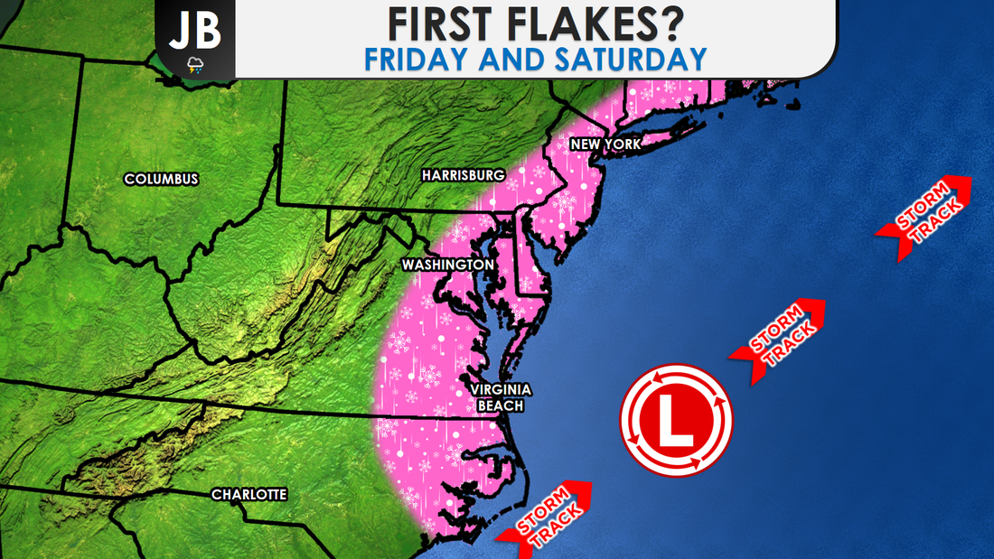
 A classic Southern storm will move up the coast today, wrapping in moisture and cold air, and producing a wintry mess of precipitation. Rain or a rain/snow mix this evening is likely to gradually transition to wet snow overnight and into tomorrow-- that could be moderate to heavy at times. Several inches are possible for areas east of I-95, with most accumulation on grassy areas. However, as snowfall rates pick up and darkness settles, slick roads will become a possibility. The snow ends before midnight. Sunshine returns Sunday, but it will be on the brisk side. I am confident that we'll have a sloppy mix of precipitation and that it will change to snow. The big questions are will it snow hard enough and will temperatures fall quickly for snow to accumulate, as I detailed this morning. The National Weather has hoisted Winter Weather Advisories for all the locations in purple. Generally, I'm expecting 2-5" east of DC, in the advised area, and 1-3 west of DC. A Winter Storm Warning, shown in pink, has also been issued as a heavier band may try to bring 5"+ of snow to Southern MD, and potentially to Delmarva as well. 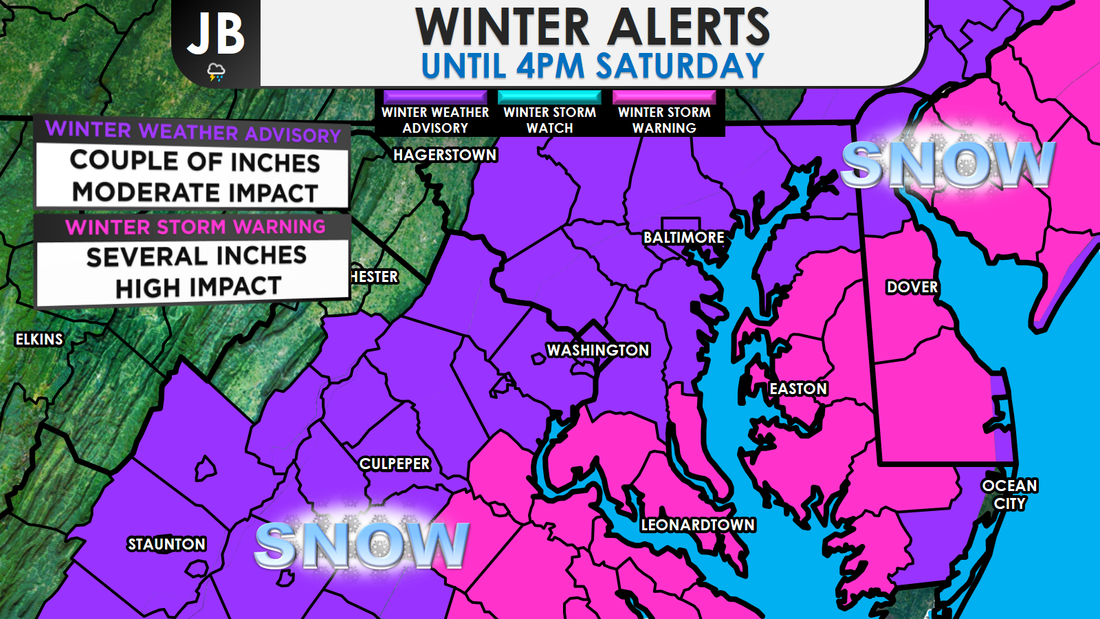 A significant obstacle for snow accumulation is the relatively "warm air" that will be in place when the precipitation first arrives (in the upper 30s to 40s in some spots). It will take some time for the precipitation to cool the air and for precipitation to change from a rain (or a rain/snow mix) to snow. In the past, some of our biggest underperforming snow events have occurred when the changeover to snow took longer than expected. And, the warm ground could limit accumulations. Precipitation has already started to move into the area. Early rain starting to mix with some snow and sleet already, which does bear good for snow lovers. Right now, all the precip is light, but it will pick up in intensity tomorrow. When will the heaviest snow fall? Most likely from sunrise to late morning.
We have talked about this storm potentially not bringing as much snow as the forecast called for. The next question is, could the storm bring more snow than expected? Yes. In order for this happen, we will need heavy precipitation to develop. That will serve to cool the air and high snowfall rates might overcome the effect of the warm ground. There's a 1 in 4 chance of 6-8" in a few spots. For that to happen, temperatures will need to be lower than forecasted, and as mentioned, heavy bands do need to set up.
Overall, as a snow lover, I'm liking what I see for this storm. All the ingredients are coming together for a decent December snowstorm, especially for Southern MD and Delmarva. A lot things are at play here, and there are a lot of variables. Stick with JB Weather for the latest updates and continued coverage! Lead Forecaster -John Bordash
1 Comment
Next Chance of Accumulating Snow: Friday - Saturday Probability of Accumulating Snow (1" or more): 60% Our first snow event of the season is on track to arrive tonight. The big question is how much snow and how big of an impact. Highs today will reach into the 40s, and ground temperatures are relatively warm, but temperatures are on their way down with chances of some accumulating snow tomorrow on the rise Light precipitation should begin during the evening. It should be in the form of rain in many spots, though a rain/snow mix is not out of the question. Temperatures will be in the mid-to-upper 30s and falling. Precipitation will spread over the area during the morning on Saturday and should stay mainly snow for areas west of the Bay, as temperatures fall to near freezing. Some accumulation is likely, especially during the morning on Saturday. Snow will mainly stick to just grassy, and untreated, areas. Snow should begin winding down around 5-8 p.m.
Another question/concern that I have are the temperatures. Throughout the majority of this event, temperatures will be in the middle 30s. That means that snow will have a hard time sticking initially. However, if the snow can fall fast enough, in heavier bands, the snow would be able to accumulate (which is what looks like will happen). Dry slots are also a concern with this storm, and where they would set up. Snow may mix with sleet and rain at times, especially along coastal areas, cutting down totals. With all this all in mind, I have to say-- this is a low confidence forecast. It's not often I say this, but, it's not a guarntee that my forecast will verify for everyone. The small micro-climates and variable conditions make this a difficult forecast. It is very possible that some see more than forecasted, and equally as possible that some see less than forecasted. Nevertheless, I think this forecast is good general baseline.
Lead Forecaster -John Bordash 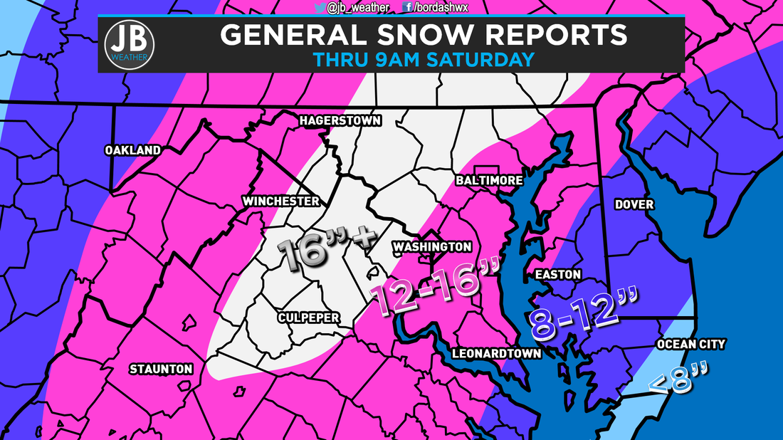 Snowfall totals so far across the region. The snow came pummeling into the DMV yesterday afternoon, and since then, we have seen a lot of it. Snowfall rates of 1-2" per hour have been common. Here, in Southern Maryland, we did also see quite a bit of sleet mix in for 4-6 hours last night. Before the sleet started, I measured 10.3" if snow here in Solomons, MD. We then added 2" of pure sleet on top of that, and have put an additional 1.2" of snow on top of that today. Below is a chart of my hourly snow totals so far. 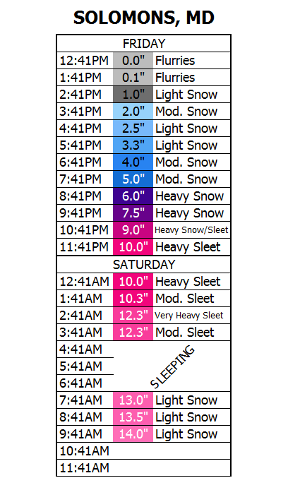 Temperatures will not make it above freezing today. This will allow for most of us to stay all snow today, and stay away from mixing problems. The only exception would be for southern Saint Mary's County where some more sleet could try to mix in. The Storm has stayed off the coast, and is currently off the Southern Delmarva beaches. Because of the storm's placement, this is when the blizzard conditions will begin across our area. Winds of 30-40mph can be expected with wind gusts as high as 50-65mph. The National Weather Serivce has extended the High Wind WARNING util 7pm this evening. 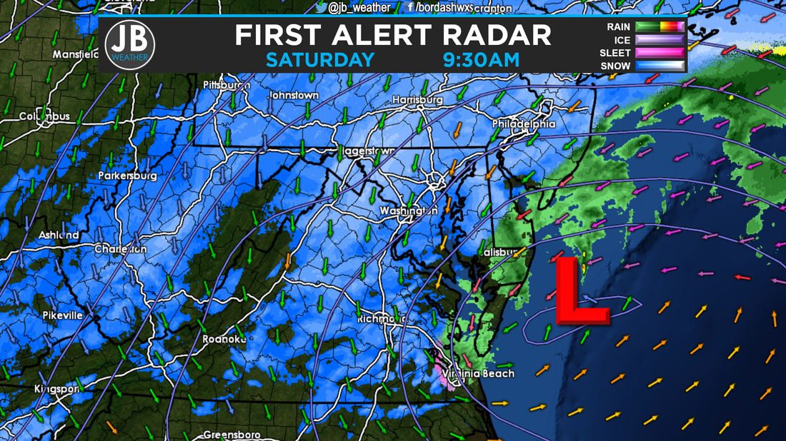 Radar and surface observations so far show our storm off the coast. The arrows represent winds. Brighter the color arrows (oranges, red, purples) higher the winds. Impacts So Far have been what we've been telling you they would be. Main roads are snow covered, and I can only imagine what secondary streets and back roads look like. We haven't see too many power outages, but that is slowly changing. So far, 67 customers are without power (as shown below). Once blizzard conditions occur, SMECO has said that, "We will not risk the safety of our crews. Restorations will resume once the winds fall back below blizzard force." And that could be as late as midnight tonight. 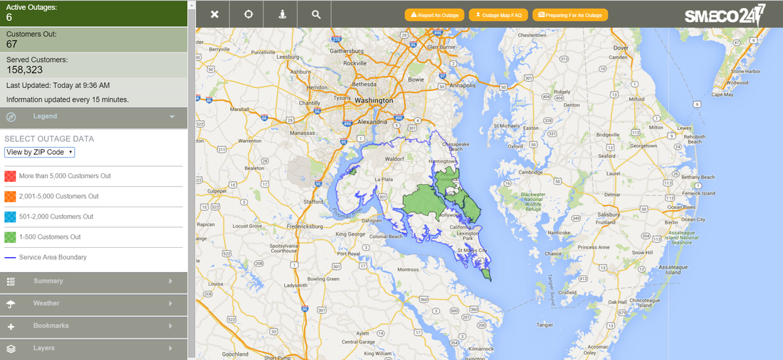 SMECO outages by Zip Code as of 9:41am. The Bottom Line is that we're in the peak of the storm from right now (9:30am) through about 5pm tonight. High winds are likely and the snow can be heavy to moderate at time. Power Outages will be likely, and travel will be near impossible. Many have already seen 12-16"+ of snow, and you can expect to add 6-12 more inches on top of that by the time all is said and done. I will continue to keep Facebook, Twitter, the website, and Periscope updated as best I can. However, in the event that I lose power, I can not guarantee that. The clean up process will start tomorrow, and will last for days. For the latest school closings and delay, I will have them on social media first!
Lead Forecaster -John Bordash 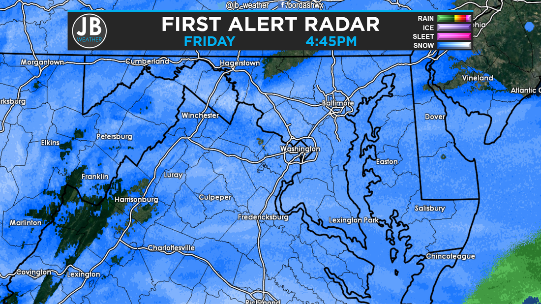 Radar as of 4:45pm, Friday. As of 4:45pm, here's where we stand right now with the Blizzard of 2016. Light to Moderate snow is falling across the region, and has been doing so since around noon today. Great call by the school districts to close today. As of 4:40, I have recorded 2.5" inches in Solomons, MD.
Temperatures are lower than originally thought. What does this mean? Well it means two things that are very important. Firstly, that means that more snow is able to fall and accumulate. After 2-3 hours of snow, most already reported 1-2" of snow. I'm sure those totals are way higher now. I expect for this to continue throughout the day. It's for this reason alone that it looks like our updated forecast should verify. Secondly, this means that it will take longer for temperatures to get to the point for mixing to occur, and when it does occur, it shouldn't last for too long, maybe just a few hours. It's for this reason that snow totals could be on the higher side of our ranges The Storm Track looks to be further south than I had expected. Our new area of low pressure is forming off the South Carolina/Georgia border, when I had expected it off the South Carolina/North Carolina border. What does this mean? This will allow our already colder than forecasted temperatures to stick around. This also means that the mixing line may not be as far north as thought. Having this further south storm track is good news for snow lovers. This by no means signifies that we'll get the heaviest snow, but it does mean that we could see some more snow. Additionally, this storm track could mean that the winds may not be as high, but could still be above 35mph. The Bottom Line is that things are working in favor for snow lovers right now. The temperatures are cold than thought, and the storm is tracking further south. Expect for the snow to continue, and increase in intensity, throughout the night. If we're going to mix with sleet or rain, it would be between 3am and 10am Saturday. However, some areas in SoMD (Huntingtown, La Plata, Lower Marlboro) may never mix. We are still expecting blizzard conditions, but the winds may not be as high as once feared. Power Outages are still possible, if not likely. Tomorrow midday and early afternoon will feature the heaviest snow for SoMD of the whole storm. The earlier arrival means that snow should leave later, and I'm thinking the snow tapers off between 5pm and 12pm Saturday. Our final forecast was for 12-18" south of Route 231, and 18-24" north of there. We're not changing our forecast, but totals could definitely be on the higher side of those ranges, and might exceed them. Stay off the roads, and inside. Snow removal personnel, SMECO crews, and emergency personnel do not need to worry about navigating around us to do their job. This storm looks to be a top 2 all-time snowstorm. Stay with JB Weather for continuing coverage. Lead Forecaster -John Bordash 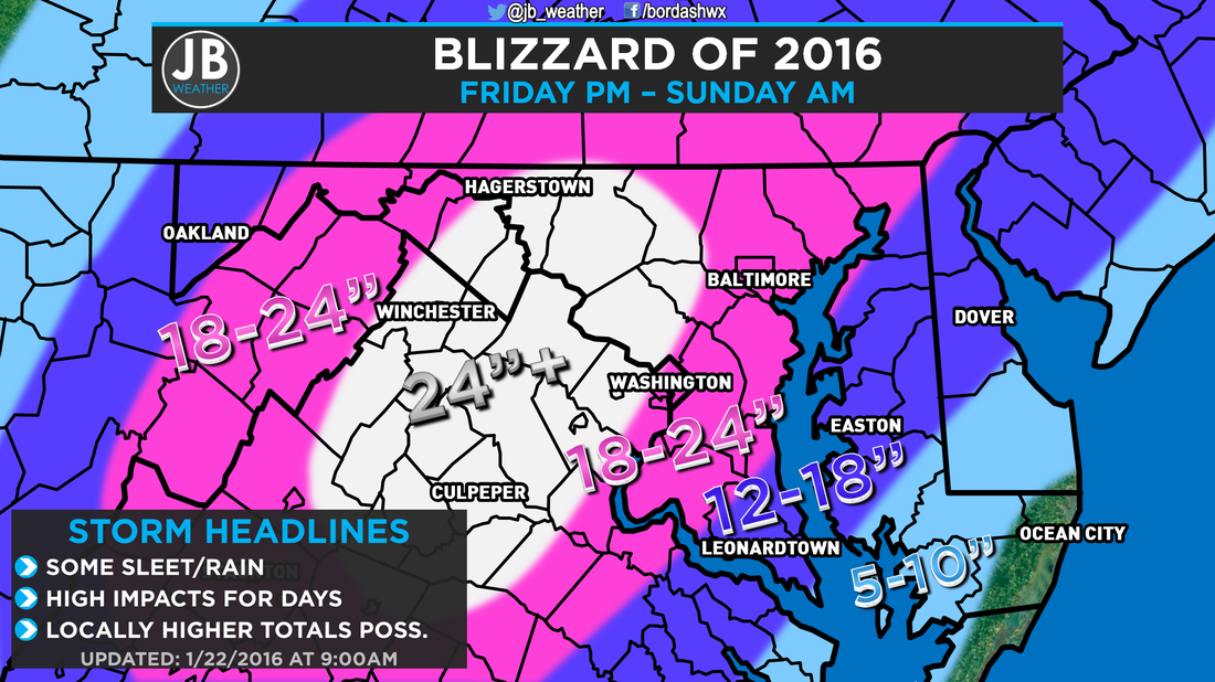 Update snowfall forecast Many who know me know that I HATE to change my forecast last minute or during a storm. However, the only time I've ever done it in the past two and half years, it was necessary. Like last time, this is a necessary update. It looks like this storm exceed my previous expectations. It looks very likely that most of the region will see at least 12" of snow, with some getting over 18".
The storm also looks to come in a bit earlier than previously forecasted. Snow should start across Southern MD between 11am and 2pm today. Some sleet and rain may mix in at time Saturday, but mixing problems will not be a big worry. Our Blizzard WARNING takes effect at 1pm today, with Governor Hogan's State of Emergency for Maryland already in effect. Many schools and businesses are already closed today, or scheduled to close early, and will remain closed all weekend. It will take days to recover from this high impact, crippling blizzard. Wherever you are by lunchtime, expect to stay there for days. SMECO announced yesterday that if the winds get to Blizzard conditions (35mph gusts for 3 or more hours) they will be forced to wait to restore any outed power until the storm comes to an end to ensure safety for their workers. For more in depth information, refer to yesterday's post. Stay with JB Weather for non-stop 24/7 coverage here on the website, the Facebook page, the Twitter page, and on my Periscope. Lead Forecaster -John Bordash |
Archives
August 2020
Categories
All
|

 RSS Feed
