
|
A weak system moving to our south is likely to spread light precipitation across the region tonight into tomorrow morning. Temperatures will be marginal, sitting within a couple degrees on either side of 32. This means a mix of snow, sleet, and rain is likely. Shown above is Futurecast timing this system out. Precip likely starts to overspread the area between 2-4am before shutting off around 10am. You can see that dry air works in, which may lead to some areas seeing close to nothing. Temps start to warm around 8/9am leading any snow/sleet to go over to rain for many. However, even rain should be done by late morning as dry air wins out. Where temperatures are colder, to the north, more of a snow/sleet mix is expected. Where it is warmer, points south of DC, it is likely to be more of a sleet/rain mix. Snow and sleet are the most likely to accumulate north of DC. Because it is warmer across southern zones I'm not expecting much snow, maybe up to inch for some. That snow is likely to be mixed with sleet. Any snow/sleet that accumulates will largely be in more rural zones, away from the water. The further south you go, the more likely you are to see a rain/sleet mix verses just snow. Below is my Final Call on snowfall.  This is not a big event by any stretch of the imagination. However, coming right before/during the AM commute could cause some problems. Impacts will be moderate for communities in Northern MD and Northern VA. Across Southern MD, the Delmarva, and Tidewater VA this may bring elevated impacts. Some traffic problems may be possible, especially on roads not treated.  What about schools? School closing odds increase the further north you head. However, I think many school systems will opt to delay. Some schools have a pre-planned 2-hour early dismissal, such as St. Mary's and Montgomery. Here, they may opt to have a delay instead of the half day. Nevertheless, I don't really see any county needing to close. Most of the winter weather should cut off around 8/9am. 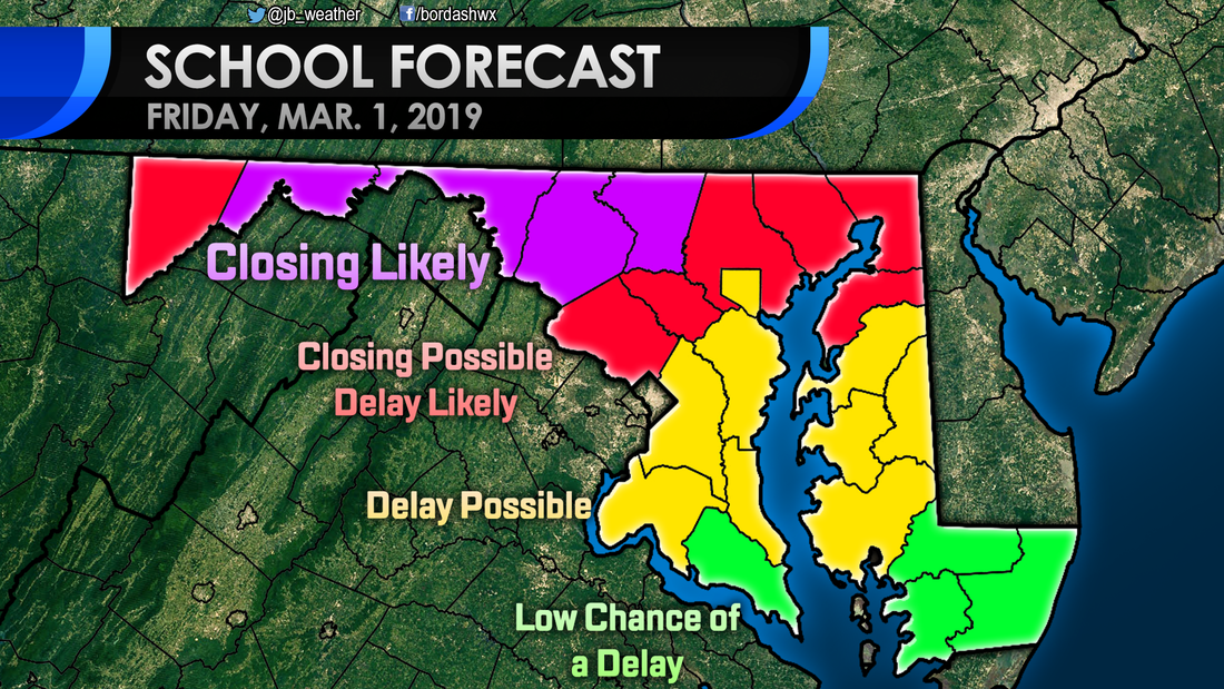 Again, this is not a high impact event, especially for southern zones. Any winter weather should shut off by 8/9am. Some school and travel delays are possible during the early morning hours.
-John A. Bordash
11 Comments
A weak system moving to our south late Thursday into Friday will usher in the chances of wintry weather across the region. This is all apart of what I view as Winter's Last Gasp. After the middle of next week, the pattern turns unfavorable for wintry weather. We will have a few shots of wintry weather until then. As mentioned before, the first one comes overnight Thursday. Shown above is Futurecast timing this system out. This system is not strong at all, so I'm not expecting heavy precipitation with this event. Nevertheless, a rain/snow mix will begin to move into far western zones around midnight. Temperatures across the region will continue to fall as the precipitation pushes eastward. With marginal temperatures south of DC, I'm not sure how much will fall as snow here. This looks to be just a sleet to rain event locally. However, once you head north of DC, it will be possible you can see a few hours of light snow. Shown below is the snowfall output from Futurecast. Remember, that is not my prediction. 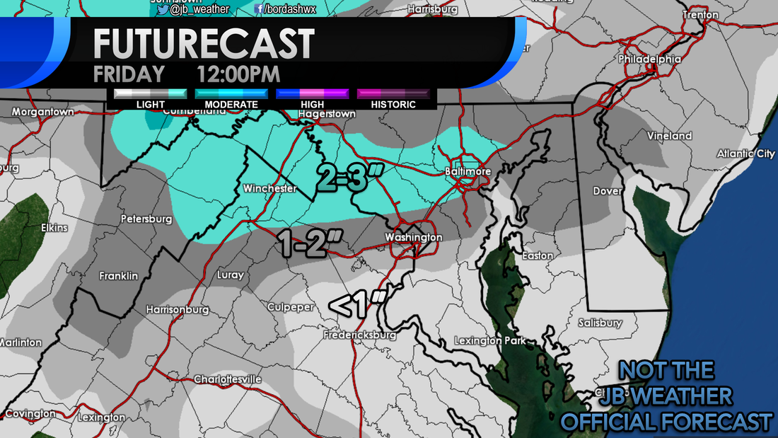 Where the precipitation stays mainly snow will be where the higher totals are. It looks like the favored zone with this event will be in a thin area from the northern DC beltway to the Mason Dixon Line. South of there, it is likely to be a snow/sleet/rain mix. Marginal temperatures will make it hard for snow to accumulate across this zone. Across the Tidewater of VA, to southern St. Mary's County, and the southern Delmarva, this looks to be a mainly rain event. Some sleet is possible here, but I do not think it will be much. Shown below is a depiction of who should see what type of precipitation and my First Call on snowfall. 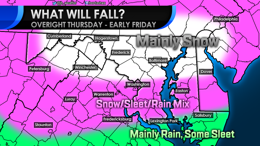 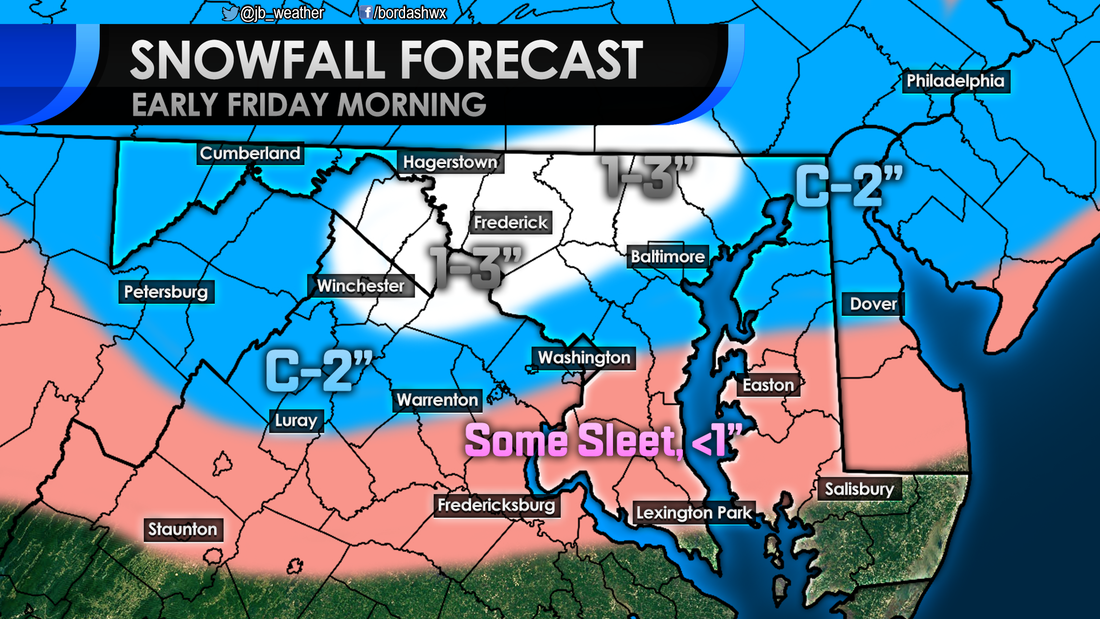 C-2" means a Coating to 2" By and large, I am not expecting a high impact event for anyone. These are rather low totals, that should fall overnight. However, the one problem here is timing. The mix of sleet and snow could have a moderate impact for northern areas Friday morning. Across Southern MD it is an Elevated impact. Some sleet could accumulate in colder locations and, "back roads." By-and-large though I am not expecting much. 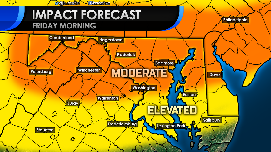 Moving forward, our next credible storm threat comes at the beginning of next week. A storm will move north from the Gulf Coast region. A high pressure to the north will dictate where this storm goes. If the storm take a track that's more to the north, warmer air will get pulled in and we will see rain across the Mid-Atlantic. If this storm takes a more southern track, we could see some wintry weather to kick off the week. There are a lot of variables at play, so not that much is known. This picture should be clearer by weeks end. 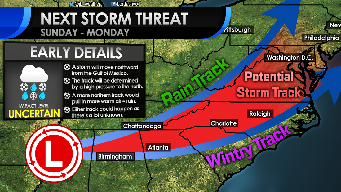 Needless to say, there is a lot to watch over the next few days. Up first will be this quick shot of winter weather overnight Thursday. I'm not expecting much snow or sleet to fall, but enough could fall at the wrong time to cause some school and travel delays. I'll be updating this forecast throughout the day tomorrow, stay tuned.
Lead Forecaster -John A. Bordash 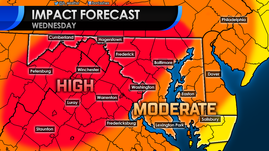 A significant winter storm still looks likely to strike the Mid-Atlantic on Wednesday. Winter weather conditions will over spread the area early tomorrow morning before transitioning to a period of ice then rain in the afternoon. Some details have come into better focus since yesterday. locally, I am still expecting a moderate impact that will likely close schools and cause travel difficulties. The National Weather Service has now issued a Winter Storm WARNING for a large chunk of the Mid-Atlantic from I-95 to the north and west. This is where the highest snow totals will be and where ice totals will have the highest impact. Across the coastal plain, including Southern MD, it's a Winter Weather ADVISORY. Snow and ice totals will not be as high here, but winter weather is still expected. 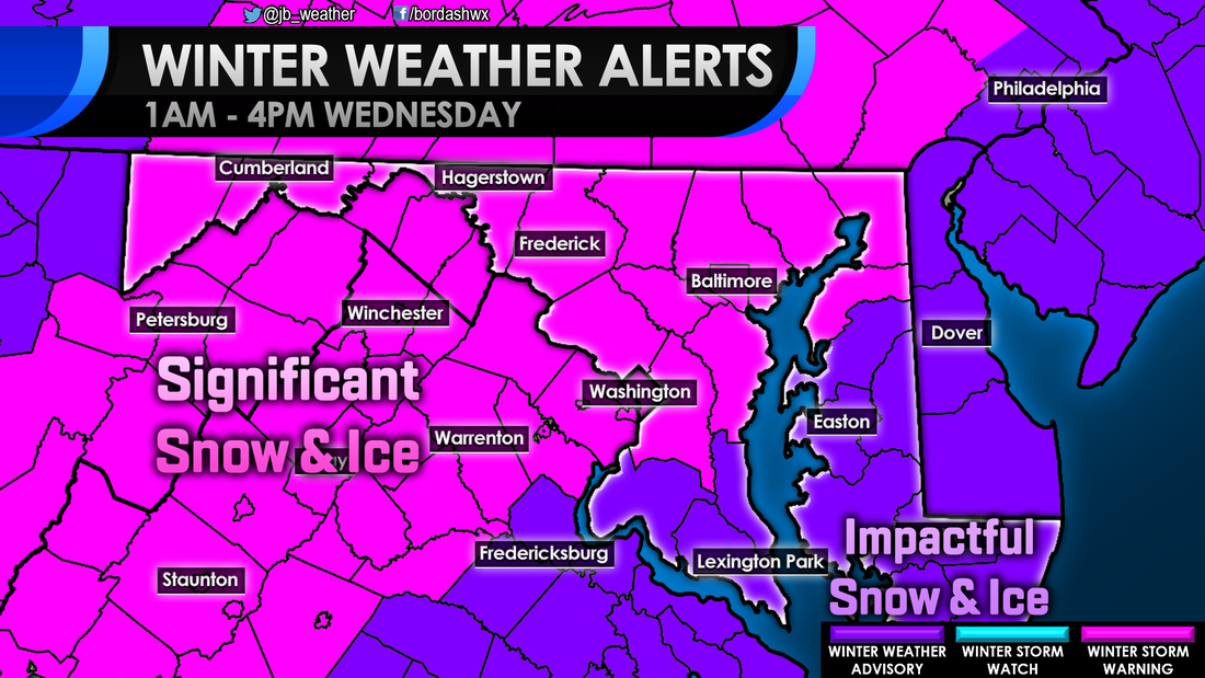 Snow still looks likely to move into the region between 5 and 8 in the morning. A change to this part of the forecast is that it looks like coastal areas in Southern St. Mary's and Calvert (locations closest to the opening of the Bay) may be a touch warmer. This could lead to localized areas of sleet or freezing rain developing there first. You can see that develop throughout the morning on the Futurecast below. Light to moderate snow continues until we hit the lunch hour; that is when the regional changeover to sleet and freezing rain will start. The most recent model runs have shown a dry slot potentially developing over area south of Route 231 by midday, as shown below. If this happens, snow and ice totals will likely be kept down. If you remember back to the January storm, many saw that dry slot happen, lowering their backyard totals just a bit. It looks like the heaviest snows will indeed stay north and west of DC. It is also there that ice may hang on the longest. This model's automated snow output very much agree's with my forecast. I do agree the idea that the heaviest snows may be kept to the north and west, away from Southern Maryland. Areas northwest of I-95 likely see over 4" of snow from this storm. Along I-95, including PG and Anne Arundel Counties, 3-5" looks likely there. Across Southern Maryland a general 2-4" looks likely, especially for those north of Route 231. South of that point across southern Calvert and St. Mary's County 1-2" is likely there. Our local forecast is very dependent on that dry slot. If it does indeed occur, then your backyard totals will likely be on the lower side. If that dry slot does not happen and heavier snows work in, then totals will be on the higher side. 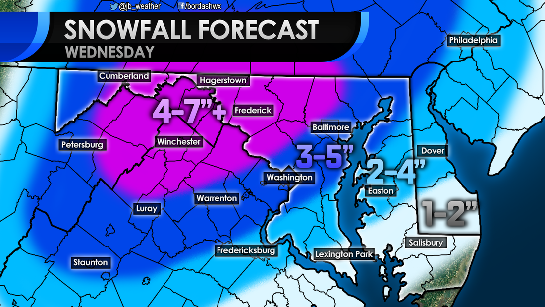 The same general rule of higher totals north and west of I-95 will hold true for the ice as well. High impacts from ice, totaling over 1/4" of an inch, looks likely in the MD/WV panhandles and across the Shenandoah Valley. From there to I-95 a moderate impact from ice totaling from 1/10" to 1/4" seems likely. It is in these two zones that Ice is almost certain for some period of time. From I-95 to the southeast to Route 231 an elevated impact from a glaze of ice will be possible. Coastal locations may be spared from ice due to that dry slot. 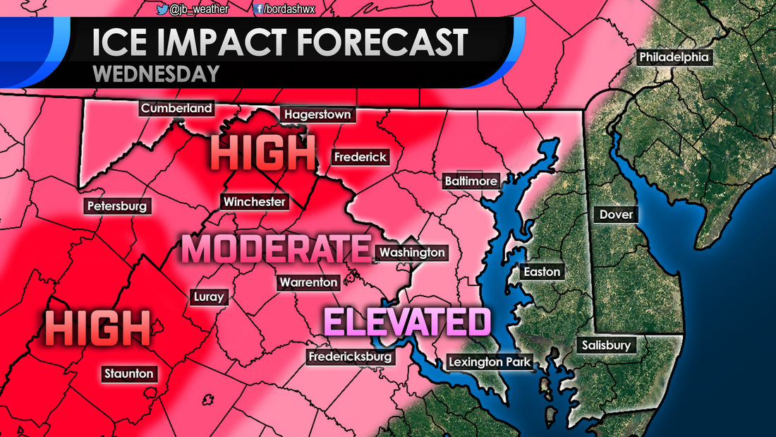 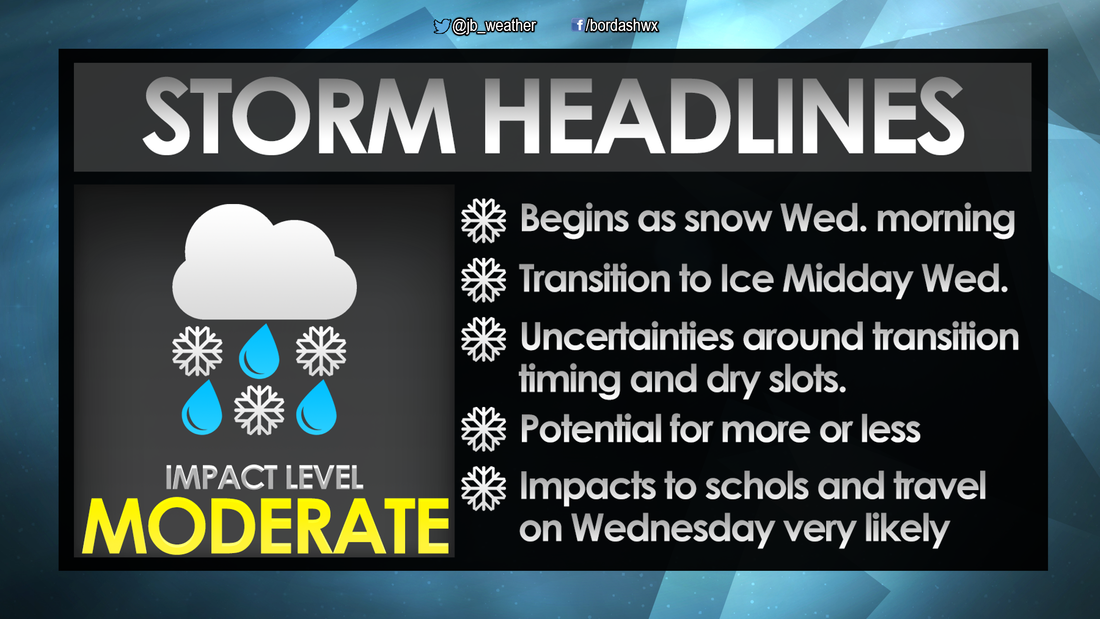 A moderate to significant impact winter storm still looks very likely for the Mid-Atlantic. I expect widespread school closings and travel difficulties. The biggest change from yesterday is that it looks like a developing dry slot may spare Southern MD from significant ice and snow. Regardless, moderate impacts are still likely though mid-afternoon. I will continue to provide updates throughout the day tomorrow to keep you ahead of the storm. Follow me on Facebook or Twitter for Southern MD weather updates!
Lead Forecaster -John A. Bordash
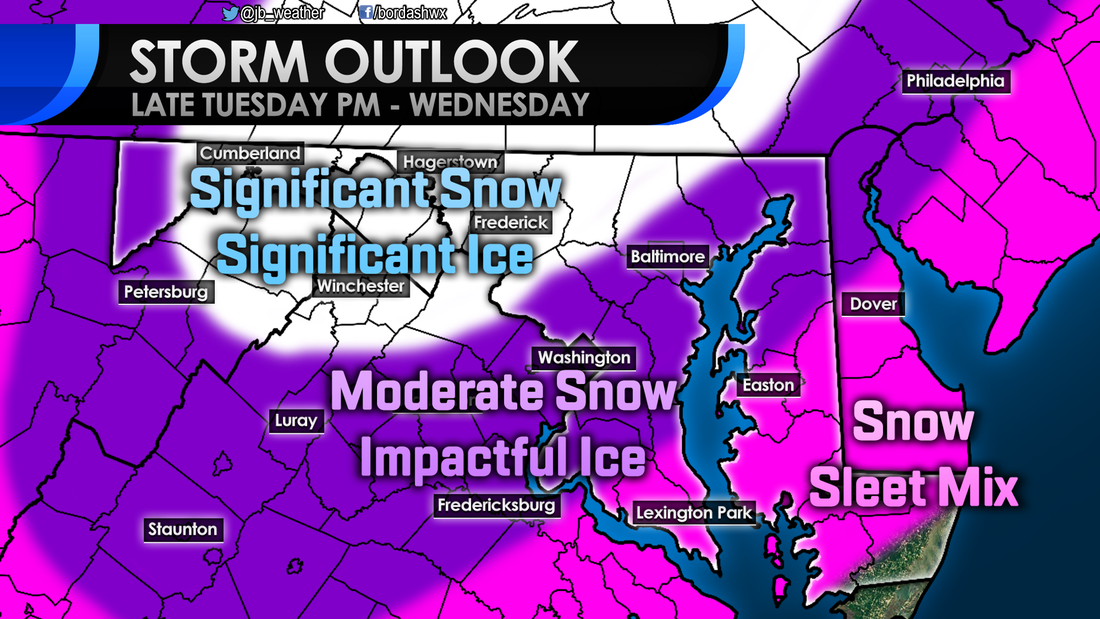
A high impact winter storm is likely to impact the region on Wednesday. Yes, schools and travel are likely to see significant impacts . This is all due to a storm that will move to our west, overspreading precipitation across the Mid-Atlantic late Tuesday into Wednesday. You may be thinking to yourself, "The biggest Mid-Atlantic snows occur normally when a storm slides to our south or off the coast to the east. How is this storm to our west going to give us winter weather?" An area of high pressure to our north will help to channel in cold air Tuesday and Wednesday. It will be because of that cold high to the north that will allow the precipitation that falls to be a wintry mix. The National Weather Service has gone ahead and issued a Winter Storm WATCH for many in the Mid-Atlantic. As you can see below, locally this does include the colder areas of Anne Arundel, Charles, and Prince George's Counties. Others outside of the Watch (like Calvert, St. Mary's, and Westmoreland) will also see snow. However, it likely will not be the magnitude the northwestern zones will see. 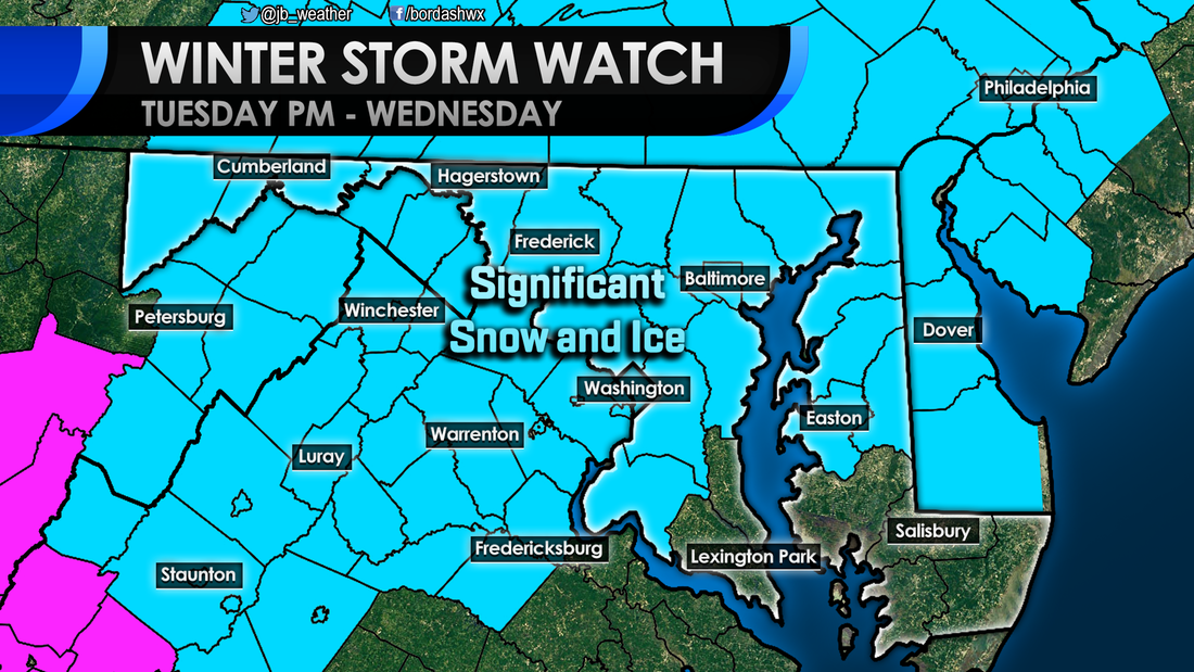 These types of set ups typically favor communities to the north and west of I-95. Because these zones are normally colder it is hear that sees the most snow and ice. However, that area of high pressure, that's pumping in the cold air, is very strong. That will lead to everyone initially starting as snow Wednesday morning. The snow could be heavy at times. Some computer model data shows areas south of DC seeing an enhancement in snowfall totals because of the heavy snow. I'm not sold on that solution yet, but it is a solution that is on the table. As you see in the timeline below, by mid-morning everyone should be seeing snow. As warm air from the south works in, the change over to sleet and freezing rain will occur around midday. This is likely to create an icy mess, especially north and west of I-95. The warm air will continue to work north, eventually turning everyone over to rain. Again, a period of snow is likely for everyone. From Ridge, to Huntingtown, to La Plata, and Annapolis most should see a period of snow in the morning. How long that period will last is uncertain. However, I would think we should see a good 3-6 hours of snow. Right now it looks like the highest totals will be northwest of I-95, where snow lasts the longest. As mentioned before, some models have consistently shown some enhancement to snow totals across areas south of DC. This is before these models show the snow hanging on longer, and showing that snow as very heavy snow. Some of your weather apps may be showing higher snow totals for Southern MD than I have shown, and that's why. I wouldn't hold my breath for that solution, but it is something to keep in the back of your head. Shown below is my first call on snowfall. 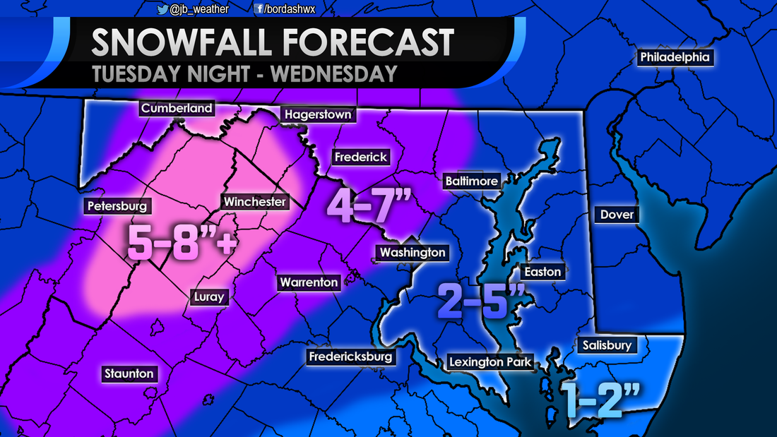 As mentioned before, many are likely to see a period of ice between the switch over from snow to rain. This transition period when the ice falls is likely to last the longest out west; where it is coldest. Western zones could see a high impact from ice, totaling over a quarter inch. Just to the northwest of I-95 moderate impacts are likely, with ice there totaling from a tenth to a quarter inch. Along I-95 and to the slight southeast, a glaze of ice could lead to some elevated impacts. Locations along the coastal plain are not likely to see an over abundance of ice. This is because those communities sit near, or right at sea level. The "warm" water temps above freezing should make the transition quicker for those areas.  Elevated: Glaze - .1" of ice Moderate: .1" - .25" of ice High: Over .25" of ice A high impact winter storm is likely to bring snow, ice, and rain the entire Mid-Atlantic. While areas north and west of I-95 are likely to see the highest totals of snow and ice, everyone should see wintry weather Wednesday morning. I do believe that many schools are likely to close on Wednesday and travel will be significantly impacted. This is a low confidence forecast. If temperatures warm quicker than expected, or a dry slot develops, totals could be lower. On the other hand, if the cold air stays longer or there are heavier snow bands, totals could be significantly higher. There's a lot to watch over the next 36 hours leading up to this storm. Prepare now, and follow JB Weather on Facebook and Twitter for the latest updates.
Lead Forecaster -John A. Bordash 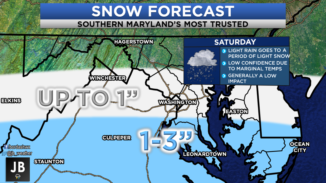 Snow still looks likely for Saturday across the Southern Mid-Atlantic. A weak area of low pressure will move to our south, overspreading moisture across the forecast region. The precipitation will be met with cool temperatures in the 30s. This set up should allow for an initial burst of rain to switch over to some light snow by midday/early afternoon on Saturday. This never has, and still does not look like a blockbuster snowstorm for our area. This should really only be a minimal event at best. As things stand right now, it looks like precipitation should move into the region during the early-to-mid morning hours. Starting as rain, we should see a transition to snow by lunch time. Relying on this transition to occur does make me nervous. There have been plenty of times where a set up like this has not produced snow, and leads to a busted forecast. This is why this forecast is a low confidence one. Shown below is the in-house Futurecast. It shows that timeline of rain going to snow by the afternoon well. Again, not looking at heavy snow, just a light but sustained light snow. Shown at the end is forecasted amounts from the American Model. While this is not my forecast, it does should that the higher snow totals will be south of DC. This should be a low impact event for many; especially since this a Saturday event. Nevertheless, this could make roadways a tad slick. With the warm temperatures on Friday, and above freezing temps on Saturday, not too much should stick to major roadways. Most accumulation should be on grassy areas. Considering this storm is weak, that means there is a higher degree of variability with the forecast. These smaller system are notorious for making last minute track and atmospheric changes. A move just 30 miles to the north could tack on another inch or two to the forecast, and bring in heavier snow. On the other hand, if this system tracks 30 miles to the south, Southern MD will not see much at all. Both of these options are very much on the table. As things stand now, a nice 1-3" of wet snow look to fall on Saturday across the region. This low impact event will have marginal temperatures to contend with, which could lead to lower snow totals. Stay with JB Weather for the latest updates on this changing forecast. 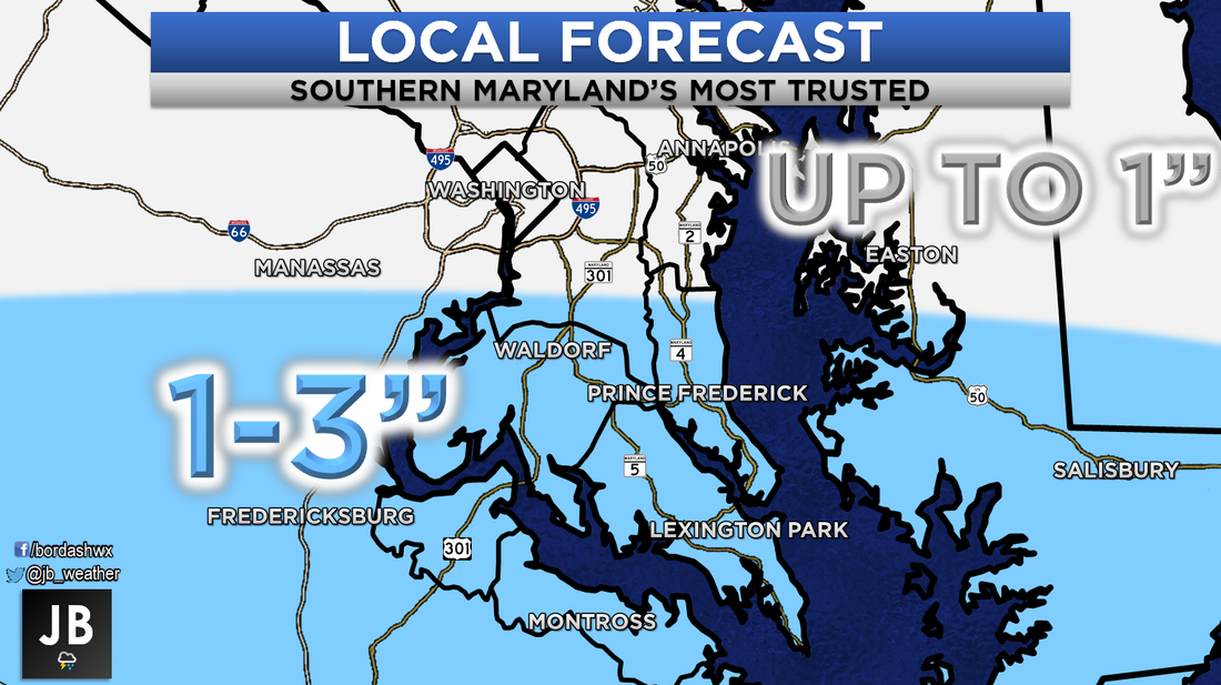 Lead Forecaster
-John A. Bordash |
Archives
August 2020
Categories
All
|
 RSS Feed
