
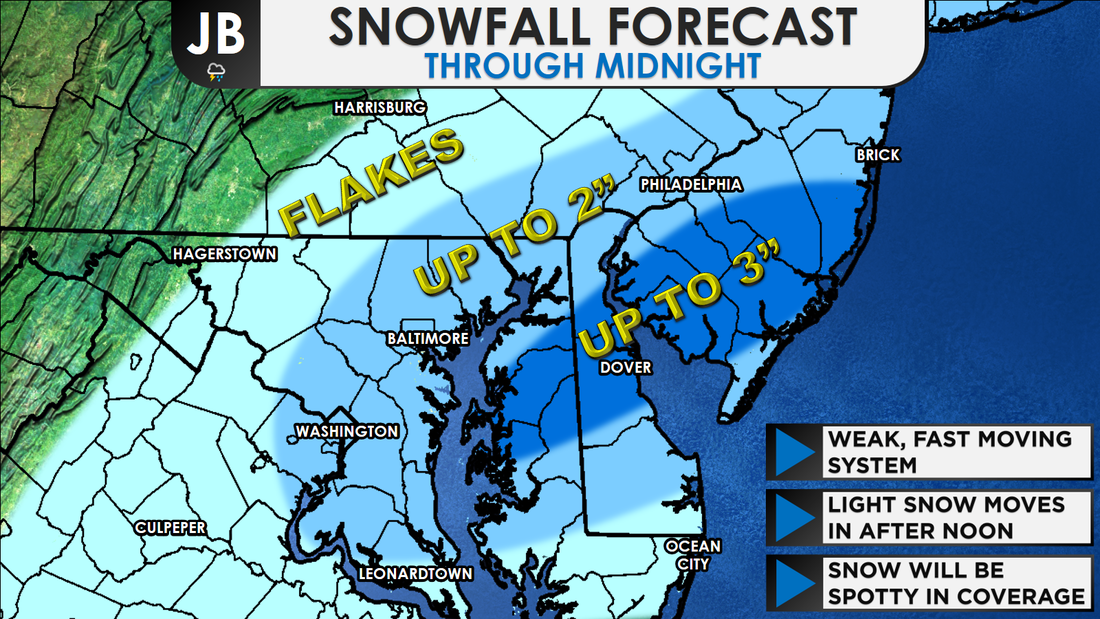
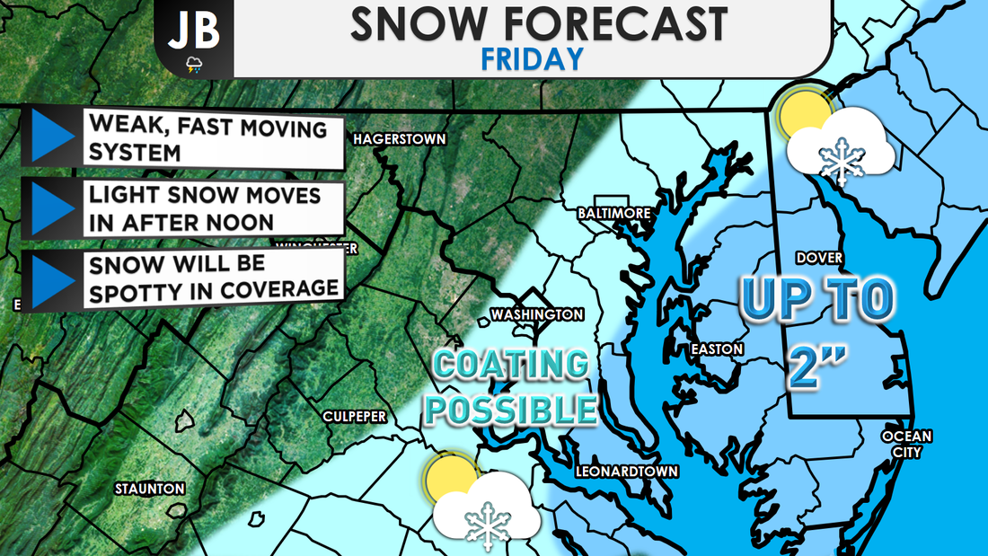
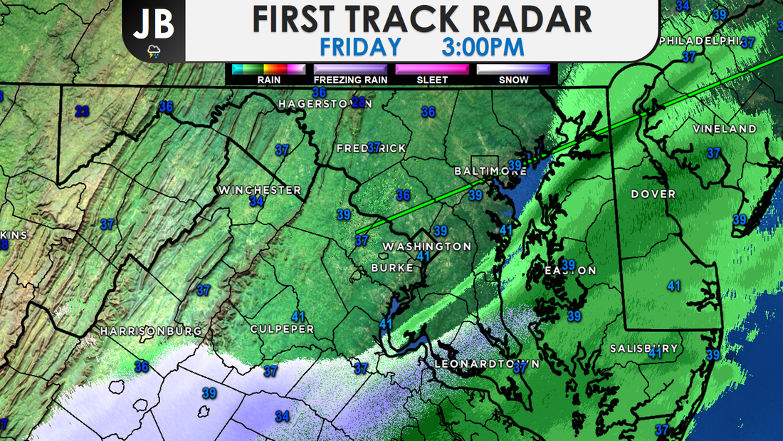
 While this still does not look like a major event-- periods of snow look to move into the region this afternoon. The snow is scheduled to move in around lunchtime, and move out around sunset, potentially effecting the PM commute. Many will see flakes, but only some will see them accumulate. With that in mind, I painted a broad stroke of "Up to 2"" east of I-95, with the idea that some may still only see flakes. The darkest blue area could see isolated amounts up to 3". 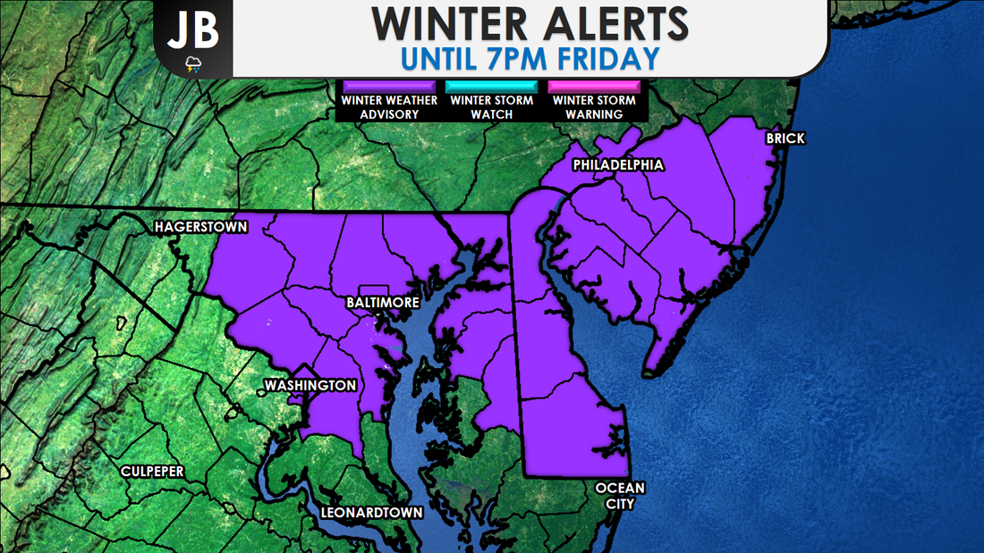 The National Weather Service has issued a Winter Weather ADVISORY from 1pm to 7pm for the immediate D.C. and Baltimore metro areas, as well as northern Delmarva and the southern Philly suburbs. This is where the highest snow totals, potentially up to the 3", looks to fall. In regards to timing, not too much has changed. Snow showers still look to break out across the region around lunchtime, ending around 5pm. As mentioned in yesterday's forecast, it's not really that a lot of snow is forecasted to fall, or that it'll be a long lasting storm that is posing possible issues. The timing is key. The light snow may be falling at just the right time to effect the PM Rush. What's more is that the heaviest snow would be falling right along the metro areas. Every flake that falls will stick, thanks to our recent cold blast that cooled the ground down. Most accumulation should remain on untreated surfaces, but main roads could become slushy if you are under a snow shower for long enough. 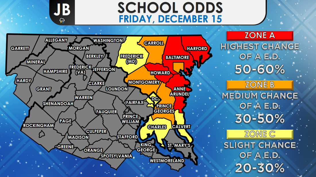 School odds for Friday 12/15. Early Dismissal is abbreviated as "E.D." This could be a very tough call for schools. Snow will likely not begin, assuming it develops, until after a decision needs to be made about early dismissals. The highest chance of these early dismissals should be northeastern school districts, where more snow could fall. This remains a fairly low confidence forecast as the region is on the edge of a storm passing to our southeast. Amounts somewhat lower or greater than the forecast are certainly possible. It is very possible that some locations may see almost no snow while other locations, just a few miles away, could see an inch or two. The further south and west you head, the lower the chance of snow. For example, Baltimore has a higher chance of seeing snow than Leonardtown does. This forecast is really all dependent on how small scale climates set up. The "bust" factor (chance of the forecast not verifying) is very high this afternoon, and I acknowledge. Stay with JB Weather this afternoon and evening for continuing updates on this system and any school alerts.
Lead Forecaster -John Bordash
0 Comments
 Some snow is looking increasingly likely for Friday afternoon, possibly coinciding with rush hour. With temperatures well below freezing, it will allow precipitation to accumulate. However, this storm system is unlikely to produce as much snow as the storm last Saturday (December 9). The best chance of around an inch or so of snow are in southern and eastern zones. Frigid air is still blowing into the area after the passage of a cold front on Tuesday. This will ensure that any precipitation we see Friday from this weak system developing off the coast will fall in the form of snow. The question remains, though: How much precipitation will make it this far north? Today's computer guidance has moved a little further north and west with the storm's precipitation shield, and placement, before the system heads out to sea. It appears that light snow could start falling as early as noon, and should be out of here around 5pm (give or take 1-2 hours). Again, this snow will not be heavy at all. However, what falls will stick, especially to grassy areas. Below is an hour-by-hour simulation of the radar from the North American Model. 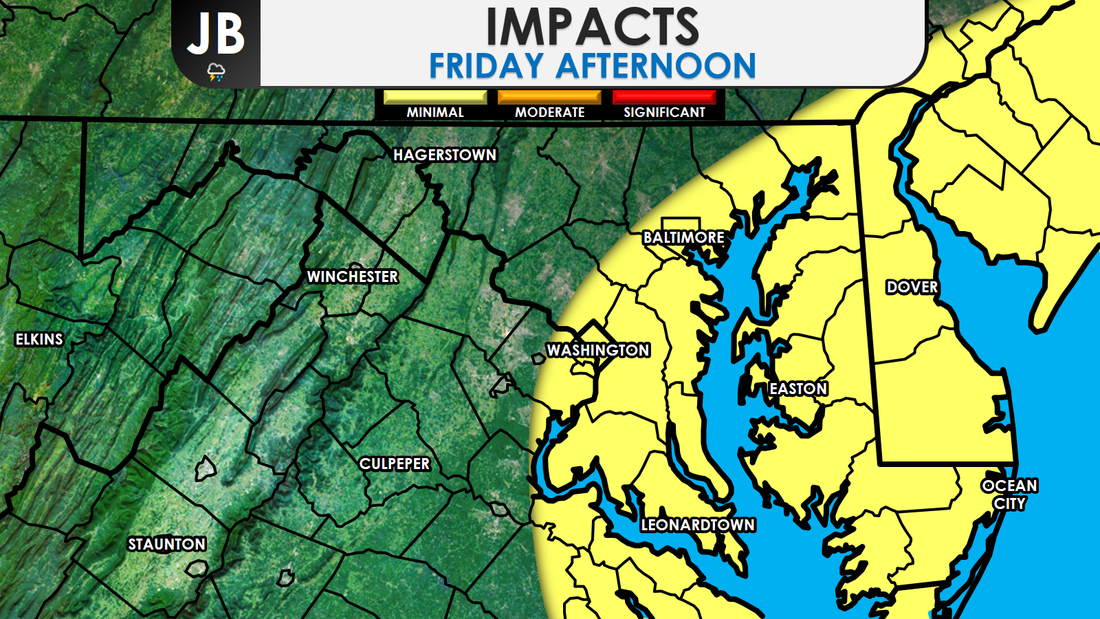 Impacts from this storm will be very location dependent, as some areas may see snow as other areas a few miles away stay dry. Nevertheless, this will not be a high impact event. Snow could accumulate on area roads, especially side streets. Even with a coating of snow, this could lead to some travel issues for the evening commute. I do not expect area schools, businesses, or government agencies to close early-- but I won't say that chance is completely zero. I would give a 15% chance of early dismissals. Stay with JB Weather for continuous updates tomorrow.
Lead Forecaster -John Bordash 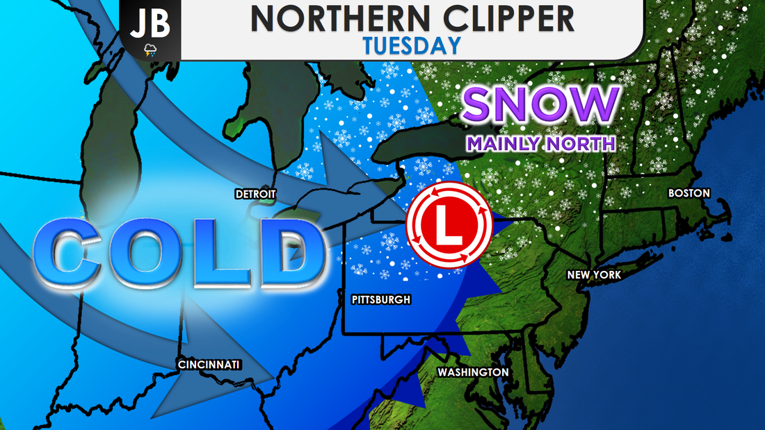 Weather setup for Tuesday. Winter made its grand entrance on Saturday with a snow that was more than conversational for some areas, but nowhere near significant. The week-ahead forecast brings more cold air, and two more chances for wintry weather. The first wintry threat comes Wednesday night and Thursday as a weak system coming from the Plains may try to throw flurries our way. As for the second... could it be two snowy weekends in a row? A reprieve from gloves, hats and scarves isn't in the forecast for this week. A fresh blast of cold air arrives Tuesday, as a weak clipper brings areas well north some snow. As the cold air spills back into the region, it will be windy. Temperatures won't change much on Wednesday as we look to stay below freezing all day, with wind chills staying below 20.
A little disturbance swinging around strong low pressure well to our north will pass just north of the Mason Dixon line, Wednesday night. In addition to promoting mostly cloudy skies, many areas will see the chance of a few flurries or a snow shower. Overnight temperatures in the middle 20s most will allow whatever could fall, to stick. However, with this system remaining weak, not too much is expected to fall. I wouldn't expect any impacts for Thursday morning, but that part of the forecast will come better into line as we come closer. Nevertheless, this really looks like more of a non-event for the Mid-Atlantic-- but it is our next best shot at flakes falling from the sky. 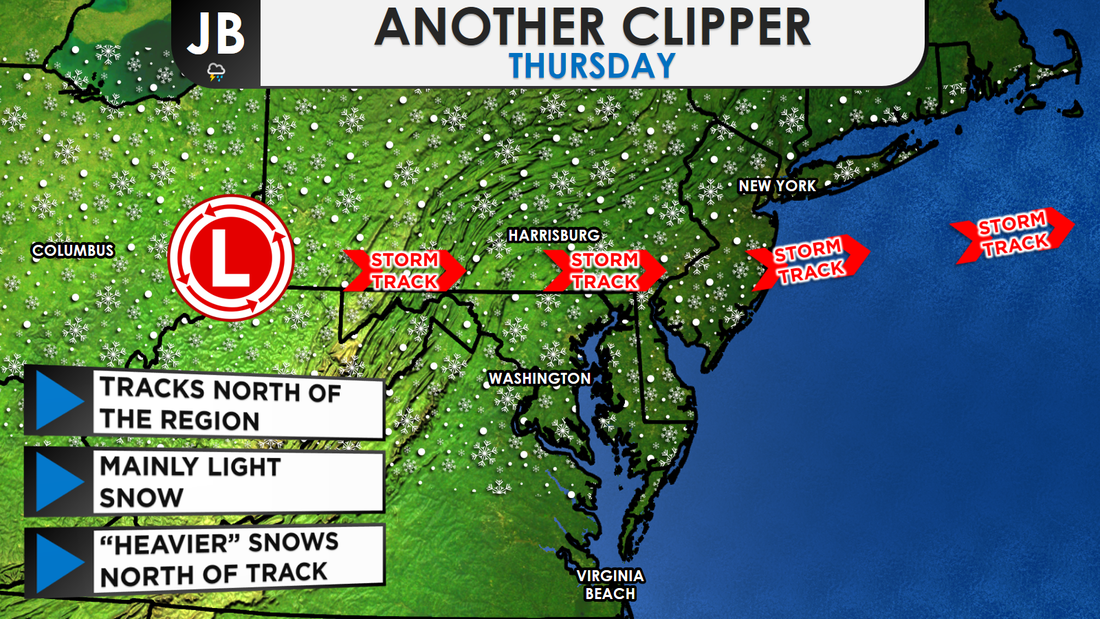 Thursday morning weather setup. Looking over some of the modeling today, there are some early signs that a storm could develop and bring the area another wintry threat sometime over the weekend. Way too early to say for sure whether the storm will indeed come to fruition and what its track and impacts would be. A few things would need to come together just right for the storm to really come together. At this time, if there were to be a storm, I don't see any signals that would point to a big, blockbuster storm. A comparable event would be something close to what happened this weekend. Nevertheless, it's too early to really talk about this possible weekend "threat". The confidence is low with this part of the forecast. The main take away's are that it's going to be turning cold for this week, and flakes cannot be ruled out either. Stay with JB Weather for updates on the forecast.
Lead Forecaster -John Bordash  Current regional storm overview. The snowflakes have been wet and fat at times, when it hasn't been raining. Many area roads are just wet this afternoon, as ground temperatures have been above freezing. Air temperatures in the mid 30s have lead to snow mainly just sticking to the grass when it's falling hard enough. Suburban locations to the south and east, like Lusby and Ridge, were coming up on and surpassing 3-4 inches of accumulation as of early-to-mid afternoon. Meanwhile most spots closer to the Beltway, in the the District, and northwest suburbs of town were in the 1-2" range. Our accumulation map from earlier seems to be mostly on track, except that many look to be on the lower end of accumulation totals. Since last night, the National Weather Service has downgraded many in Southern MD from the Winter Storm Warning, which actually still remains for St. Mary's, to a Winter Weather Advisory. However, all advisories and warnings have been extended until 9pm tonight, as the snow seems to last longer than initially thought. 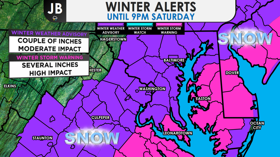 After last night's initial burst of snow across far southern and eastern areas, there a 5-6 hour lull in the activity this morning. The snow didn't start to get going until mid-morning and there have been a few dry slots, and areas of mixing across the region. Both of these have lead to lower totals than some assumed. I never really bit on to the idea of major, substantial snow totals. The final call from yesterday had many in a 2-5"+ range, but I did acknowledge the very many caveats to this forecast. Some outlets were forecasting 6-8"+ totals, which always seems a bit overzealous to me. Another inch or so is possible before the snow tapers off around 6-8 p.m. Please drive carefully as wet roads can quickly turn slushy and slippery during heavier bursts of precipitation. Lead Forecaster
-John Bordash 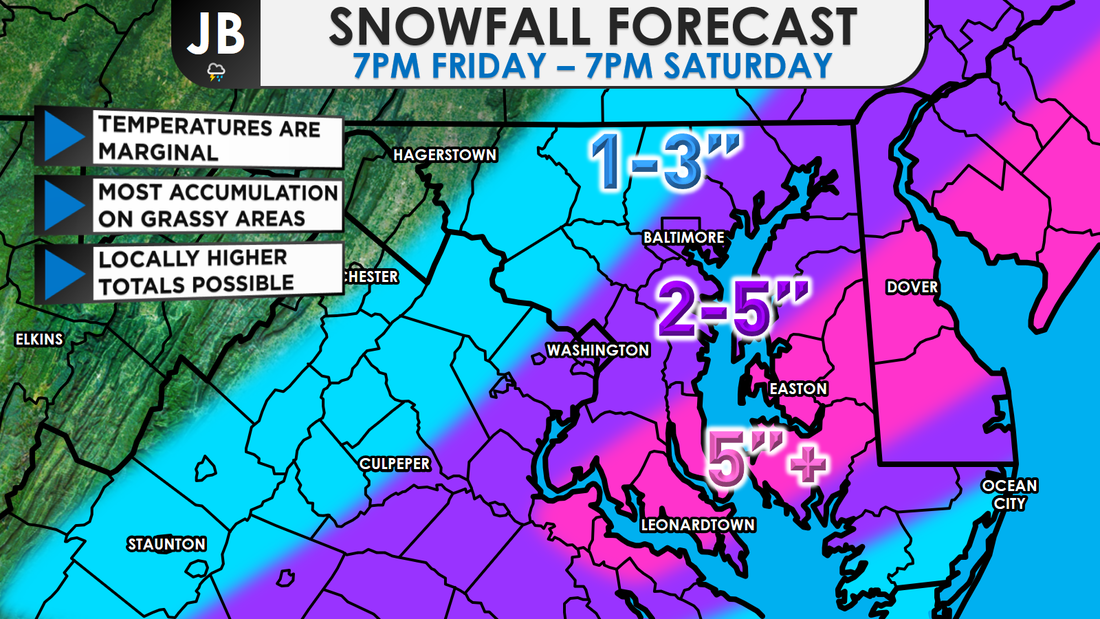 A classic Southern storm will move up the coast today, wrapping in moisture and cold air, and producing a wintry mess of precipitation. Rain or a rain/snow mix this evening is likely to gradually transition to wet snow overnight and into tomorrow-- that could be moderate to heavy at times. Several inches are possible for areas east of I-95, with most accumulation on grassy areas. However, as snowfall rates pick up and darkness settles, slick roads will become a possibility. The snow ends before midnight. Sunshine returns Sunday, but it will be on the brisk side. I am confident that we'll have a sloppy mix of precipitation and that it will change to snow. The big questions are will it snow hard enough and will temperatures fall quickly for snow to accumulate, as I detailed this morning. The National Weather has hoisted Winter Weather Advisories for all the locations in purple. Generally, I'm expecting 2-5" east of DC, in the advised area, and 1-3 west of DC. A Winter Storm Warning, shown in pink, has also been issued as a heavier band may try to bring 5"+ of snow to Southern MD, and potentially to Delmarva as well. 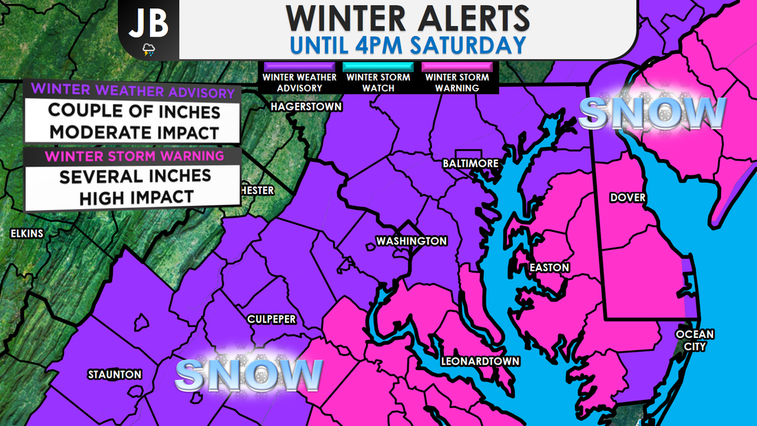 A significant obstacle for snow accumulation is the relatively "warm air" that will be in place when the precipitation first arrives (in the upper 30s to 40s in some spots). It will take some time for the precipitation to cool the air and for precipitation to change from a rain (or a rain/snow mix) to snow. In the past, some of our biggest underperforming snow events have occurred when the changeover to snow took longer than expected. And, the warm ground could limit accumulations. Precipitation has already started to move into the area. Early rain starting to mix with some snow and sleet already, which does bear good for snow lovers. Right now, all the precip is light, but it will pick up in intensity tomorrow. When will the heaviest snow fall? Most likely from sunrise to late morning.
We have talked about this storm potentially not bringing as much snow as the forecast called for. The next question is, could the storm bring more snow than expected? Yes. In order for this happen, we will need heavy precipitation to develop. That will serve to cool the air and high snowfall rates might overcome the effect of the warm ground. There's a 1 in 4 chance of 6-8" in a few spots. For that to happen, temperatures will need to be lower than forecasted, and as mentioned, heavy bands do need to set up.
Overall, as a snow lover, I'm liking what I see for this storm. All the ingredients are coming together for a decent December snowstorm, especially for Southern MD and Delmarva. A lot things are at play here, and there are a lot of variables. Stick with JB Weather for the latest updates and continued coverage! Lead Forecaster -John Bordash |
Archives
August 2020
Categories
All
|


 RSS Feed
