
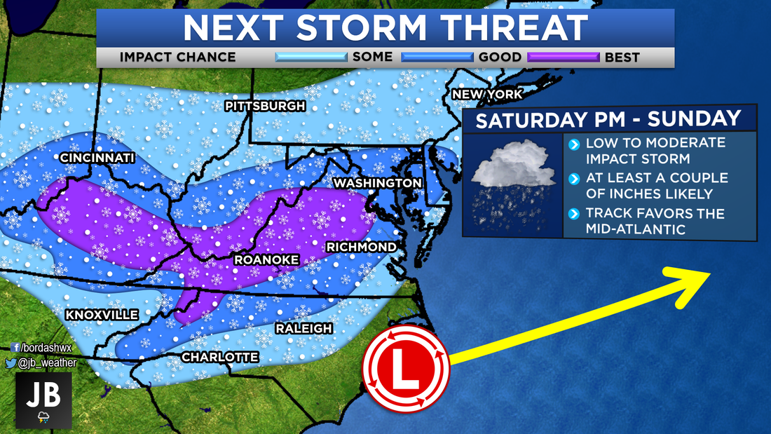
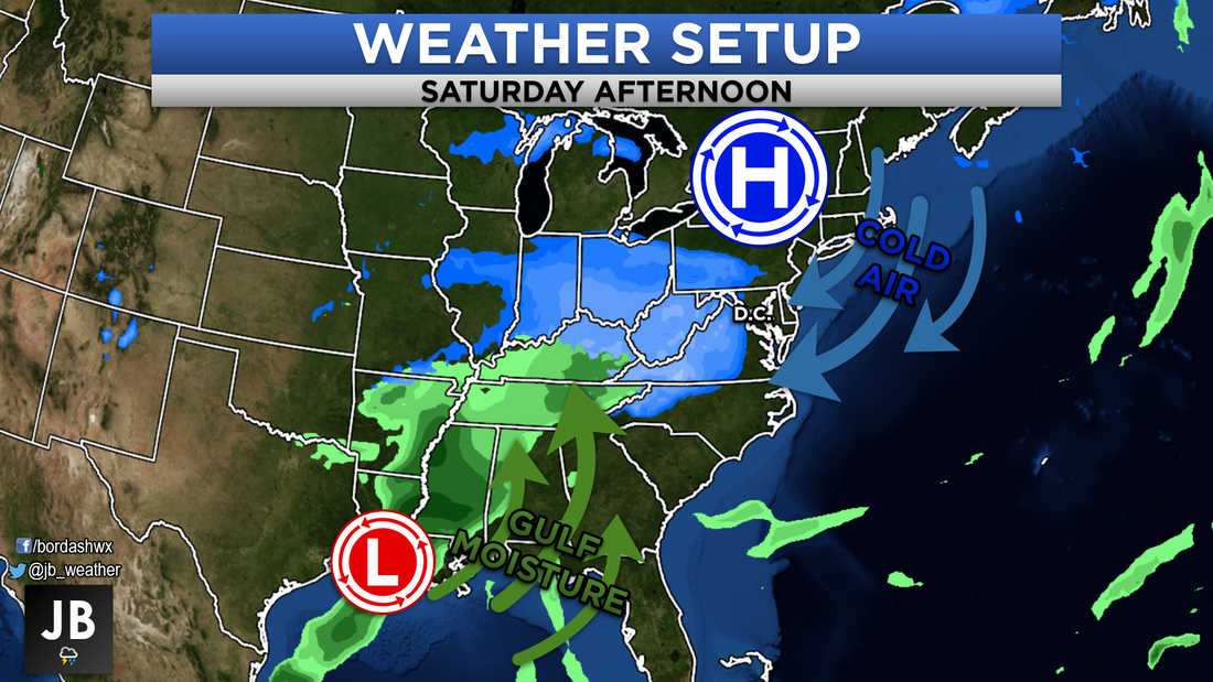
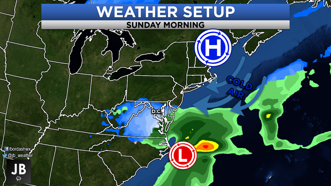
 Chances of seeing impactful snow this weekend. Next Chance of Accumulating Snow: Saturday Afternoon into Sunday Probability of Accumulating Snow: 80% Outside of two winter weather makers early this season, Winter 2018-2019 has been rather uneventful. We have seen quite the number of storms move through and impact the region the last few weeks. However, the lack of cold air has lead to all of these being just rain makers. It does appear that our fate is changing though. As stated in my winter forecast, we are beginning to embark on what looks to be an active second half of the winter. The active stretch should kickoff this weekend, with the first snow threat of 2019. Last night's line of moderate rain helped to introduce an area of high pressure to the region that is helping to funnel in cold air. By tomorrow its presence will be felt on the heels of gusty winds. It will be this area of high pressure that is in-part responsible for this storm. With its placement to our north, it will force this developing storm to our south. This is an ideal setup for Southern Maryland snow. Shown below is a snapshot of our setup on Friday. Our system will be developing in Texas, and will be inducing a large swath of Moisture from the Gulf of Mexico out ahead of it. 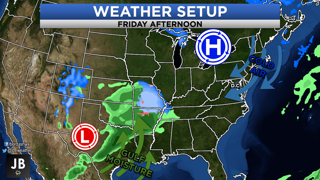 Our storm system will trek across the southern tier of the country late this week. With this track, areas in Missouri, Illinois, Indiana, and Kentucky could tap into some decent to significant snow. As the northern piece of this storm races out ahead, some snow could begin to fall in the Mid-Atlantic as early as Saturday afternoon. This initial wave should not be too impactful, but will coat most surfaces. It will be when the main southern storm moves along reaches the coastline that local impacts will begin to ramp up. Light to more moderate snows will kick off overnight Saturday and should last through a good chunk of Sunday. The area of high pressure to our north should provice more than enough cold air to the Mid-Atlantic to keep our precipitation all snow.
The exact track and strength of this storm are not nailed down just yet. Both of those will have profound impacts to our forecast and how much we will see. If this storm were to track further north, we would see the heaviest snow move further north (away from SoMD) and maybe mix our snow will some sleet or rain. If this storm tracks further south, we would only see light snow, and it would be confined to areas south of DC. I believe our final solution will end up somewhere between those two tracks. Where our storm comes far enough north to bring some decent snow to our region, but not far enough north that we deal with the rain/snow line. As we sit 3-4 days out from this storm effecting us, it is looking likely that this will be a decent sized storm. While this will not be the biggest event Southern MD has ever seen, it is a nice ease back into the winter grind. The graphic below shows the storm's impact. Shown are general ranges for snow totals, do not take them as gospel. Look more so at the impacts described. Nevertheless, Sunday will be the most impacted day. Travel looks to be impacted the most with the accumulating snow. As shown in the initial graphic, Southern MD stands a good shot to see snow. It looks like the best chances of heavy snow will be just to our west. 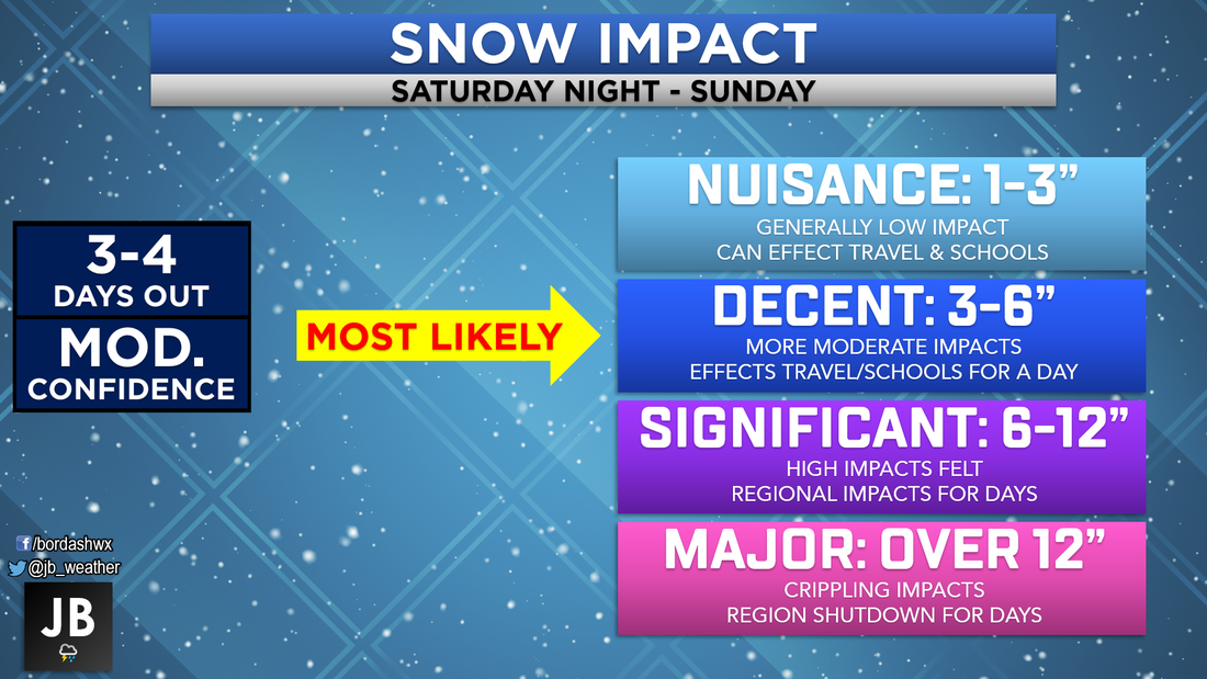 Current forecasted impact level from this storm. We are starting to get more information as things come better into focus with this system. There are still a lot of things to be worked out; namely with the track. Due to that, I will hold off on releasing any specific forecast map until tomorrow evening. Tomorrow is when this storm will come on shore in California, and we can start measuring it's parameters. This means that some changes are still possible with this forecast. Stay with Southern Maryland's most trusted source of weather information for continuous updates. I will have updates both on Facebook and Twitter.
Lead Forecaster -John A. Bordash
1 Comment
|
Archives
August 2020
Categories
All
|
 RSS Feed
