
|
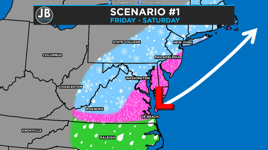
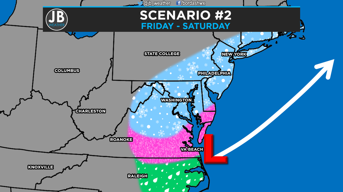
Long video discussion about the storm. Everything I talk about in this video is also talked about below in the blog update. Next Chance of Accumulating Snow: Friday - Saturday Probability of Accumulating Snow (1" or more): 90% It looks like we could be facing our first potential major winter storm late this week. Cold air being driven southward will converge with precipitation being pushed northward Friday into Saturday. However, our cold air is not expected to exceptionally strong, and the potential snow could be of a wetter variety along with some mixed precipitation. Due to the intensification of the storm, it looks like we will have to deal with some high winds as well. All of our weather models with this system have been surprisingly consistent this far out. However, expect that the forecast could change a few times as the storm fully get sampled late tonight. Nevertheless, the very active subtropical branch of the jet stream in this pattern suggests that this storm will have an ample moisture supply. Additionally, with a cold area of high pressure to the north of us, in southern Canada, the Mid-Atlantic looks to be in a highly favored position. As usual, the storm track will be a key factor in determining how much and what type of precipitation we see, so I've set up two scenarios for the storms. Below is a depiction of both scenarios.
My early outlook is that this storm will likely be the biggest storm in the past 6 years. I'm favoring a track that's closer to the coast, and one that limits the amount of cold air. Nevertheless, we will still see quite a bit of wintry weather. We may mix with rain at times, but that's to be expected with winter storms. I believe that this storm's "bullseye" will be centered right on the Mid-Atlantic, but away from the coast. Below are my chances on what type of winter storm we will be dealing with.  Storm potential for Southern Maryland. The Bottom Line is to expect a winter storm that looks to start sometime either late morning or midday Friday that lasts until sometime Saturday afternoon. There are still a few unknowns, mainly concerning storm track, which ultimately affects precipitation type. It's still too early to put out any snowfall forecast numbers with this storm, but nevertheless, this will be a high impact storm with high winds. This forecast still has the potential to change over the next few days with new information that comes in. However, if you're planning on flying out Friday afternoon or anytime on Saturday, your flight is likely to be delayed or canceled. You may be able to get out Friday morning, and definitely on Thursday. 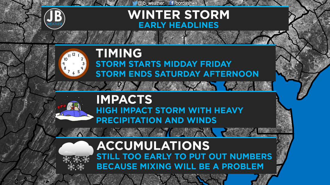 Stay with JB Weather for the latest information on Southern Maryland weather. I plan to have my first call on snow totals sometime tomorrow, probably in the afternoon or evening. Lead Forecaster -John Bordash
0 Comments
Next Chance of Accumulating Snow: Friday - Saturday Probability of Accumulating Snow (1" or more): 50% For non-snow lovers in the Mid-Atlantic, this is has been your winter. Record setting warmth in December with no snow at all, and a pretty quiet January. The area just picked up its first measurable snowfall after an over performing storm on Sunday, and even that was small. Well non-snow lovers, your luck may be running out. Our storm chance covers the period from early Friday through Saturday. This storm does have the potential to be big, as I'm sure most have heard. However, there are large uncertainties with respect to its evolution and track. There is high confidence a storm will develop near the Gulf Coast states midweek and then head northeastward. But as with all storms from the south, the exact track it takes will determine how much impact it has on the region. A more inland track could mean some snow before a changeover to rain and/or mixed precipitation. A track too far to the south and east would result in little, if any, precipitation. A track just off the coast, in between the first two tracks mentioned, would mean the potential for significant snow, which is what some of our more reputable models are showing like the European. I don't disagree that there is the potential for a significant precipitation event somewhere in the Mid-Atlantic late this week but I should stress it is very unclear whether this precipitation event will manifest itself as a significant snowstorm. As we have witnessed throughout the winter so far, many snowstorms simulated 5+ days out by computer models have a high chance to not materialize. Below is an image from the American Model which shows some mixing problems for Southern Maryland because of the winds coming off the water (represented by the arrows). 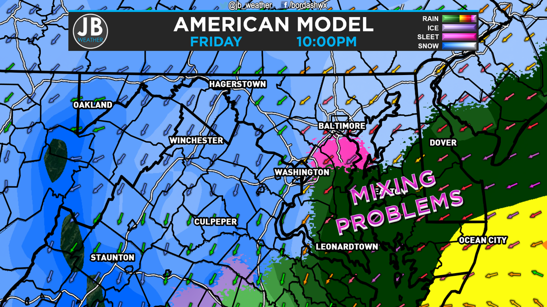 The American Model showing some mixing issues for areas south and east of I-95. Keeping everything in mind, here's my assessment of our current snow potential:
Nuisance Event: 30% Disruptive Event: 40% Significant Event: 20% Historic Event: 10% Summary I still think it's too early to latch on to an exact track, but I do tend to think the inland scenario is a tad more likely than the other two I described which would mean some significant precipitation for the region. My other hunch is that cold air may be in shorter supply meaning rain and/or sleet may enter the picture. You're going to see a lot of images over the next few days of crazy snow totals along with a lot of hype. All I can say is to do is just ignore those sensationalist, and keep it locked in with JB Weather for the latest throughout the week. Lead Forecaster -John Bordash 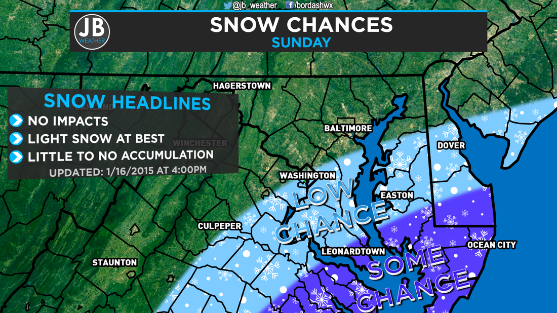 Current forecast for tomorrow's snow chances. Over the past few days, there has been some talk over a system that will be sliding well to our south, off the Southeast coastline. At one point, the American Model had even showed a sizeable snow event for area. Needless to say, that doesn't appear likely. However, we could see some flurries or snow showers tomorrow. As shown above, our forecast is that there is at least some chance (30-40%) that the purple areas see some flakes, while the blue areas have a low chance (20-30%) at flakes. This storm will be sliding well to our south, so don't expect much. Will this be a big blockbuster storm? Nope. But this could offer some conversational snow. In addition to a storm track that is too far south and out to sea to give us a decent snowfall, temperatures could also become an issue for whatever precipitation does fall. Temperatures tomorrow will max out in the upper 30s and lower 40s. While it's not impossible to snow at those temps, we could have some very light rain showers that mix in as well 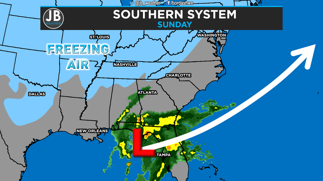 Projected location of the system early tomorrow morning along with its predicted storm track. Freezing air, shown in blue, could be too far north to have all precipitation fall as snow. All in all, tomorrow should not be an active weather day. We could see some snow or rain showers that work in across the area. The further south and east you head, higher the chance for precipitation. Below are the chances for accumulation amounts. 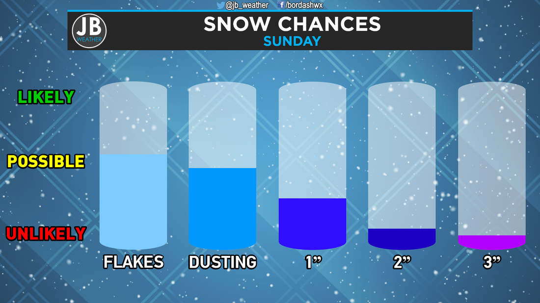 Tomorrow's snow chances for Southern Maryland. I cannot believe that in mid-January, this storm has the best shot to bring us snow thus far, and it'll be minor amounts in the best setup! Nevertheless, stay with JB Weather for the latest on all things Southern Maryland weather!
Lead Forecaster -John Bordash |
Archives
August 2020
Categories
All
|
 RSS Feed
