
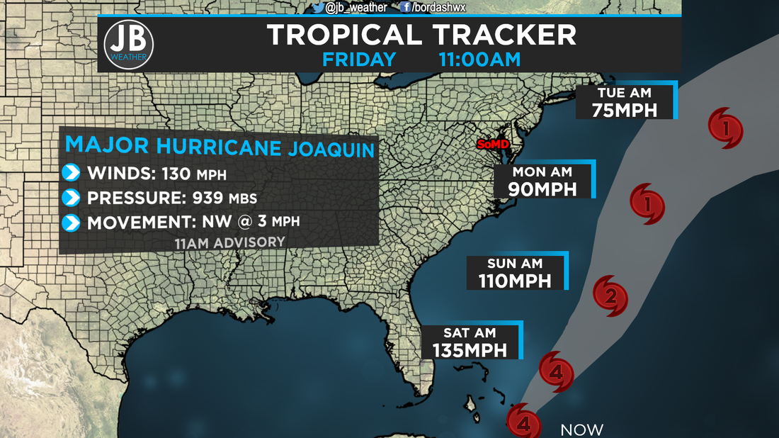
 11AM Stats on Joaquin and Forecast Cone (in gray) from the National Hurricane Center A lot has become evident over the last 24 hours. Joaquin's forecast is beginning to become more clear as we sit with rain and wet conditions for the next 24-36 hours in the Mid-Atlantic. There's a lot to talk about, so let's get started. Major Hurricane Joaquin The forecast with Joaquin has becoming increasingly more clear. The forecast models we rely on the most with tropical weather forecasting are continuing to prodce out to sea tracks. However, it is important to note that they did come a bit west last night. Because of Joaquin's decreased speed, and it's delayed NW turn, the blocking high that would send it into the coast weakens, so it moves out to sea. What that means is that if Joaquin doesn't get kicked out to sea, it will just move north, pass Cape Cod, and into Atlantic Canada. Below are my scenarios
Wet 36 Hours Ahead This part of the forecast has always been pretty easy. Today and tomorrow, we're going to see a lot of rain with wind. All of this rain should erase any rainfall deficits we may have. This system looks to be the first real Nor'Easter of the season. I think the heaviest rains with the highest winds hit between 4pm today and 4am tomorrow morning. After about noon is when the chance of rain starts to fall from 90% to near 60%. I think we don't reallty start to clear out until Sunday, but even then we still have a 40% chance of rain. Below is a look at the current alerts we have in effect around the region 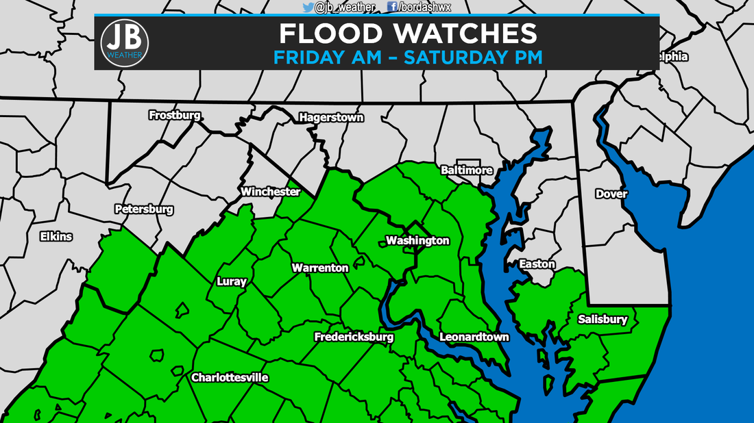 Flash Flood Watch is in effect for all 5 SoMD Counties 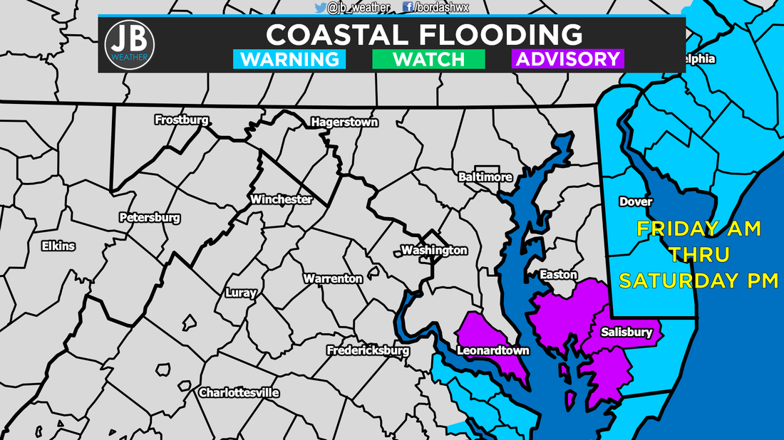 Coastal Flood Advisory for St. Mary's County for minor coastal inundation. Coastal Flood Warnings for the Atlantic seaboard as major coastal flooding is likely. 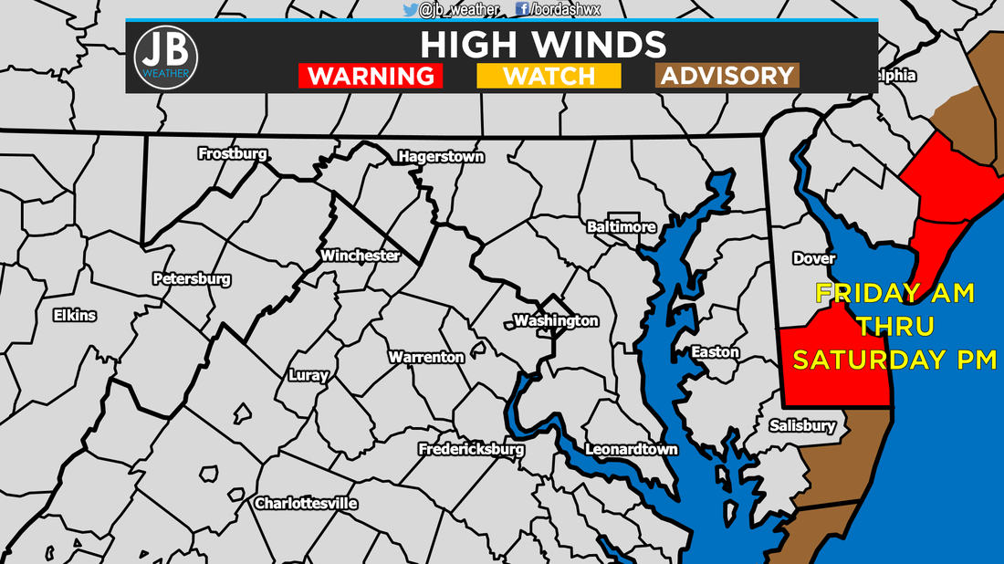 Wind Advisories and High Wind Warnings are up for the Atlantic seaboard where the winds are expected to be the highest. Conclusion I can now say with 90% confidence that Joaquin will head out to sea. We will contiue to see moderate rains from the Nor'Easter the next 36 hour. The worse of the weather will be from 4pm - 4am. Below is a look at forecasted rainfall totals. 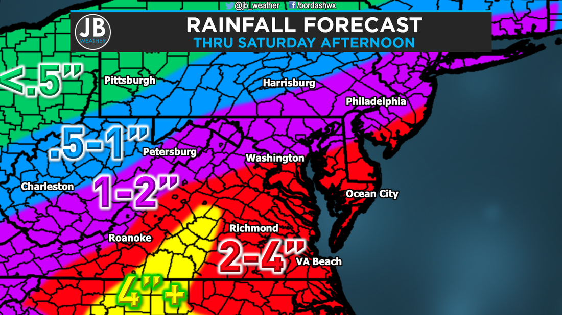 All in all, while some may criticize my earlier forecasts, and call this a bust, I'm happy it is. A landfalling Category 2 or 3 hurricane in SoMD would cause so much destruction and devastation. This area would look like a natural disaster zone. We dodged a huge bullet this time, but next time we may not be so lucky. Stay tuned to JB Weather for the latest Southern Maryland weather forecasts. This will be my last Joaquin update. Stay safe, stay dry, and stay warm.
Lead Forecaster -John Bordash
1 Comment
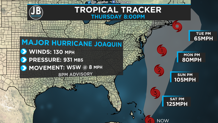 8PM Advisory on Joaquin from the National Hurricane Center Nobody ever said that forecast with Joaquin would be easy, and it has proven that it won't be. So much has been coming in over the past 24 hours, and we're beginning to get a better idea about the storm. However, this forecast still have low confidence. Joaquin Right Now Major Hurricane Joaquin is currently a monster Category 4 storm, that is raking havoc in the Bahamas. Joaquin is actually the strongest storm in the Atlantic since Igor in September of 2010. Hurricane Warnings have been in place for the Bahamas for a couple of days now. As I have discussed in previous posts, the remnants of former Hurricane Ida have been the major driving forecast of the short term forecast, which then effects the long term. Major Hurricane Joaquin is continuing to push further southwest, as shown above in the 8pm Advisory from the National Hurricane Center. This continued southwesterly push has potential to be good news for us. Joaquin's Forecast Needless to say, this forecast has been hectic. However, I've always said that we need to keep all scenarios on the table, and even tonight I will continue to say that. The weather models we look at have had Joaquin's intensity forecast off for the most part, so it's been hard to put much faith into their track forecast. Nevertheless, almost every model we look at with tropical weather, including one of our two major models, the American Model, showed Joaquin tacking up and in to the coast over the past few days. While most our models showed this scenario, the European, the second major model we look at, has continued to show an out to sea track. We weren't putting much faith in the European, as every other model showed another track, and considered it an outlier. Well, last night, the American model, along with a few others, started to trend towards the European. Now that Joaquin has continued to move more southwest than forecasted, it's beginning to appear that the European may be correct. Now, I'm not going to outright advertise an out to sea track. This storm will either come up and in to the Mid-Atlantic coast, or out to sea. There is not much of a middle ground. Below are my scenarios based off of what I've seen tonight. SCENARIO A (40%) MID ATLANTIC LANDFALL This is the worse case scenario. Keep in mid that the chance of this happening is starting to go down, but it is far from 0%. How does this scenario play out? The storm gets pulled north by the Jet Stream, and flung into the coastline from the strong high. With this, landfall could be anywhere from Southern New Jersey to Cape Hatteras, North Carolina. What would this mean for us? Well, I'll go in the middle with a Virginia Beach landfall as a Category 1 storm, and here are the impacts:
SCENARIO B (60%) OUT TO SEA This scenario is the best case one. This scenario's chances are becoming more likely, due to the continued southward progression, but this is can not be solely advertised this solution. How does this scenario play out? The storm interacts too much the remnants of Ida, continues to move southwest over the next 12 hours, and gets "ejected" out to sea by the Jet Stream. With this, it would be as if Joaquin had never even formed in terms of impacts here. What would this mean for us? Here are the impacts:
Putting it all Together
It is needless to say that things are difficult with this forecast, but we may have found a way out of a dangerous situation. However, I will not write off a Mid-Atlantic landfall, it would be irresponsible to do so. I still think a Mid-Atlantic landfall is still a real possibility. This storm will need to start moving north tonight to give us an impact. Additionally, I do not think that the current forecast track is not realistic. This storm will either move up and into the coast, or out to sea. I've said before that we will know more by tonight, and we do, the chance of an out to sea track is rising. Friday will be the day to confirm one scenario. Stay with JB Weather on Twitter, Facebook, and right here on our website, for the latest on this storm. I may do another video update tomorrow. Stay tuned. Lead Forecaster -John Bordash 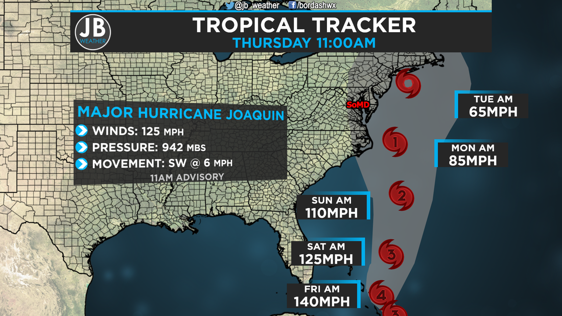 11am Advisory from the National Hurricane Center on Joaquin I will preface this with: this will not be a long a post as I'm writing this in between classes, but wanted to get something out. Expect a longer, more detailed, post this afternoon. Major Hurricane Joaquin Late last night, Joaquin continued to rapidly strengthen, and is now classified as a Major Hurricane. The storm currently sits near the Bahamas, and is not really moving all that fast. Hurricane Warnings are now in effect for the Bahama Islands. Last night's model runs caught on to something that was not really looked at as a high possibility, the out to sea track. Over the past couple of days, almost every model we look at with tropical weather, including one of our two major models, the American Model, showed Joaquin tacking up and in to the coast. While most our models showed this scenario, the European, the second major model we look at, has continued to show an out to sea track. We weren't putting much faith in the European, as every other model showed another track, and considered it an outlier. Well, last night, the American model started to trend towards the European. In yesterday's blog post I detailed how this storm would go out to sea. Right now, the storm is continuing to get pushed southwest from Ida's Remnants. If Joaquin continues to go southwest this evening, the chance of an out to sea track goes up dramatically. The National Hurricane Center's latest forecast cone now show a shift to the east, but the track they show is unlikely. This storm will either come up and into the Mid-Atlantic, or out to sea. I see no real way this goes straight up the coast. So, what do I now think will happen? My thoughts have changed, and below are scenarios: SCENARIO A (50%) MID ATLANTIC LANDFALL This is the worse case scenario. How does this scenario play out? The storm gets pulled north by the Jet Stream, and flung into the coastline from the strong high. With this, landfall could be anywhere from Southern New Jersey to Cape Hatteras, North Carolina. What would this mean for us? Well, I'll go in the middle with a Virginia Beach landfall as a Category 1 storm, and here are the impacts:
SCENARIO B (50%) OUT TO SEA This scenario is the best case one. How does this scenario play out? The storm interacts too much the remnants of Ida, continues to move southwest over the next 18 hours, and gets "ejected" out to sea by the Jet Stream. With this, it would be as if Joaquin had never even formed in terms of impacts here. What would this mean for us? Here are the impacts:
Conclusion
Needless to say that things are getting really difficult, but we may have found a way out of a serious situation. However, I will not write off a Mid-Atlantic landfall, it would be irresponsible to do so. I still think a Mid-Atlantic landfall is still a real possibility. It is important to note that the chance of an out to sea track is rising. Again, I will have a more detailed post this afternoon after the 5pm advisory from the National Hurricane, but I need to get off to class now. Stay tuned to JB Weather for the latest information on Joaquin. Lead Forecaster -John Bordash 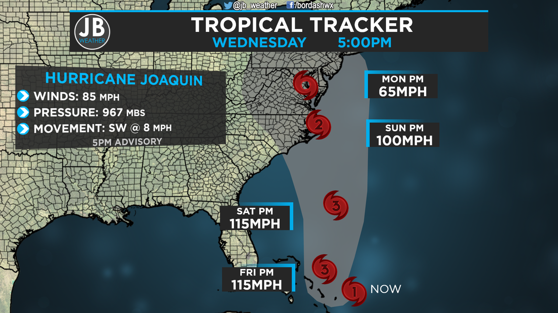 5PM Stats and Forecast Cone (in gray) from the National Hurricane Center Since yesterday, Joaquin has intensified into a Category 1 Hurricane. This storm continues to strengthen, and I see no reason why that would stop over the next 72 hours. The 5pm advisory from the National Hurricane Center is close to a "worst case scenario" for us in Southern Maryland. Tonight, I'm going to walk you through why this is happening, how the weekend is looking right now, and what you should be doing at this moment. For information on the different track scenarios, scroll down past the Rainfall Forecast. Pattern Setup This is a very difficult pattern to explain. On the map below, white arrows are steering winds. Anyway, here's the skinny of the setup:
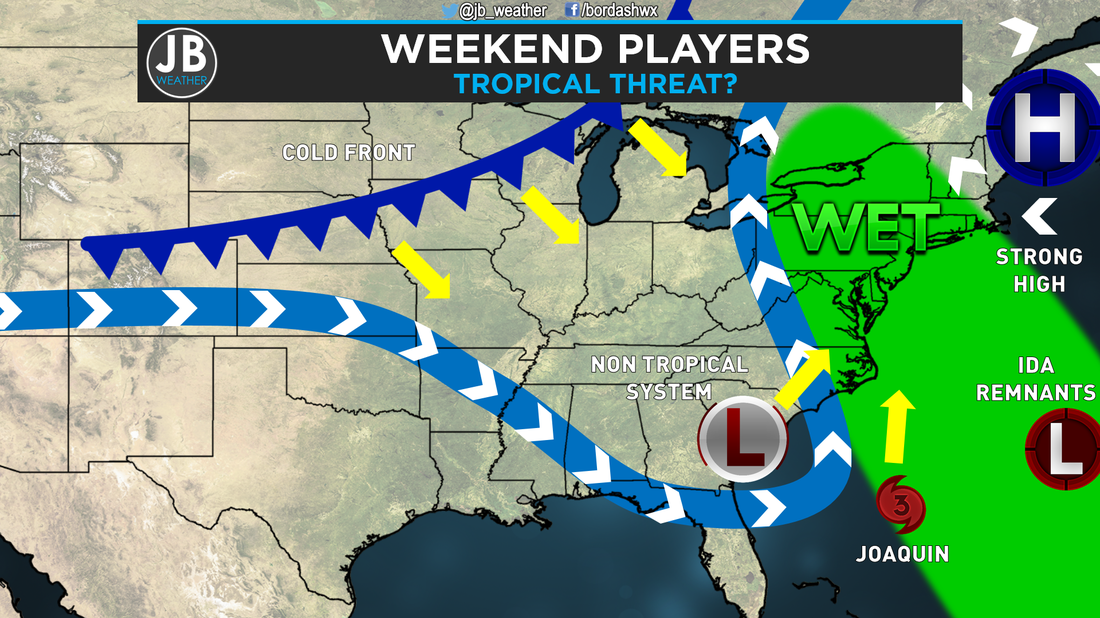 Weather setup for this weekend As everything stands right now, it appears that Joaquin will get "picked up" by the Jet Stream, and flung somewhere in the Mid-Atlantic. The strong high to the north will prevent it from going too far up the coast, and will also help to back Joaquin into the coastline. Lastly, Ida's Remnants are going to be the biggest influence on this forecast. Right now, Ida's Remnants are forcing Joaquin to go down to the southwest, towards the Bahamas. That track was always forecasted. However, if Ida's Remnants continue to force Joaquin down to the southwest tomorrow afternoon, the Jet Stream will instead fling it out to sea. The European model has shown this type of a solution, thus, cannot be written off. If Ida's Remnants were not there, this forecast would be ten times easier, as we could say with confidence that this will track into the Mid-Atlantic. Weekend Forecast Discussion Before Hurricane Joaquin even became a worry, the threat of heavy rain was always in the forecast from that Non-Tropical Low as shown above. Right now, it appears that we'll see impacts from that feature starting Thursday Afternoon (originally Friday) and through the day Sunday. How much rain will we see? Take a look below at the rainfall forecast. Remember, 4-8" of rain in SoMD is without Joaquin. Now do you see the flooding issue Joaquin could pose? This amount of rain alone would case serious issues. 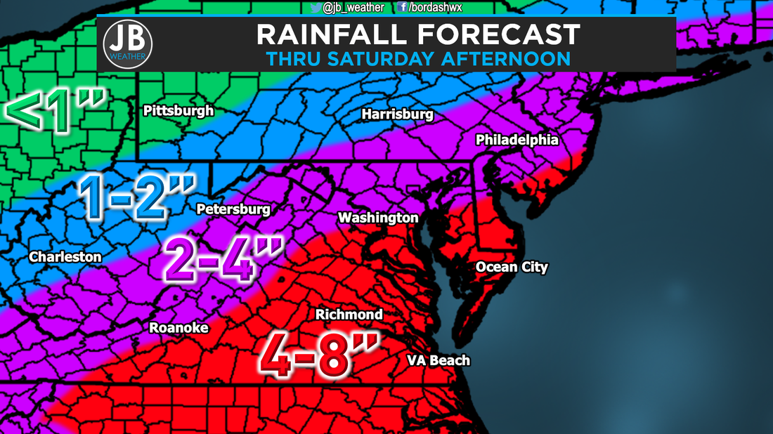 Rainfall forecast Thursday - Saturday Now we talk about Hurricane Joaquin's possible impact on our region. The National Hurricane Center's newest forecast take what could be a category 2 storm, right up the Chesapeake, with a direct hit on Southern Maryland. I could not think of a worse track. The only other track that would be slightly worse is if the storm tracks more to west (or left). Below are my different scenarios on what could happen: SCENARIO A (50%) MID ATLANTIC LANDFALL This is the worse case scenario, and the one that the National Hurricane Center is adverting. How does this scenario play out? The storm gets pulled north by the Jet Stream, and flung into the coastline from the strong high. With this, landfall could be anywhere from Southern New Jersey to Cape Hatteras, North Carolina. What would this mean for us? Well, I'll go in the middle with a Virginia Beach landfall as a Category 2 storm (like the Hurricane Center has), and here are the impacts:
SCENARIO B (30%) SOUTHEAST LANDFALL This scenario would be better than Scenario A, but is also no walk in the park. How does this scenario play out? The storm gets pulled north by the Jet Stream, like with Scenario A. However, the high is stronger and/or further south, and the storm gets flung into the coastline further south. The storm would go north after landfall, just over land. With this, landfall could be anywhere from Virginia Beach to the South Carolina/North Carolina line. What would this mean for us? Well, I'll go in the middle with a Cape Hatteras landfall as a Category 2 storm, and here are the impacts:
SCENARIO C (20%) OUT TO SEA This scenario is the best case one. How does this scenario play out? The storm interacts too much the remnants of Ida, continues to move southwest over the next 36 hours, and gets "ejected" out to sea by the Jet Stream. With this, it would be as if Joaquin had never even formed in terms of impacts here. What would this mean for us? Here are the impacts:
Putting it All Together Now that you know what we're going to be dealing with, and why, what should you be doing right now? Well, at the moment, you just need to keep it locked in with JB Weather and start thinking of what you would do if Scenario A occurred. Pray for the best case scenario, but be thinking what you'll do if the worst case happens. No need to run out to the stores just yet, but be aware. Below is an image of the areas that need to be aware of Joaquin: 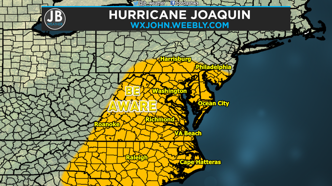 Current thoughts on who needs to be aware with this storm Right now, I expect periods of heavy rain with some wind starting Thursday Afternoon through Sunday. If Joaquin does in fact come into the coast, we'd see more heavy rain with wind Sunday into Monday. Keep in mind, nothing is set in stone with Joaquin, and all scenarios are still on the table. Tomorrow afternoon and evening, I'll be able to say with more certainty what will happen. Until then, keep it tuned in with us here at JB Weather. The weather team is working around the clock to keep you all informed. Next advisory on Joaquin comes in at 11pm tonight. Follow us on Twitter and Facebook for the latest updates.
Lead Forecaster -John Bordash Here are my updated thoughts on Hurricane #Joaquin. I apologize for the long video, but there is a lot to go over. I'll have a blog post out this evening for my updated thoughts.
|
Archives
August 2020
Categories
All
|
 RSS Feed
