
|
Next Chance of Accumulating Snow: Saturday Afternoon into Sunday Probability of Accumulating Snow: >95% Moderate to Significant snow totals are likely to impact the Mid-Atlantic Saturday afternoon into the day on Sunday. This winter storm looks to set it's highest impact area in a zone from Central Virginia to Southern Maryland. Lesser, but still admirable, impacts will be felt further north towards the Mason Dixon Line. Shown above, I have increased my snow forecast to a healthy 4-7" throughout the region. Ahead of the storm, the National Weather Service has issued a Winter Storm WARNING for all of Southern Maryland and Tidewater Virginia. Winter Weather ADVISORIES are up for northern counties that will see lower snow totals. Those weather alerts are shown below. 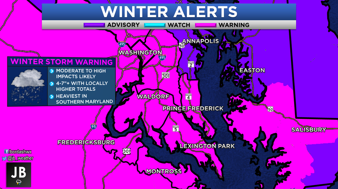 Our storm is currently developing in Texas. With the storm's current placement there, it is allowing for a nice flow of moisture from the Gulf of Mexico to occur. Cold air is pretty entrenched across the northern tier of the country; which is allowing that moisture to fall as snow. That is all shown below on the 5pm Friday radar snapshot. 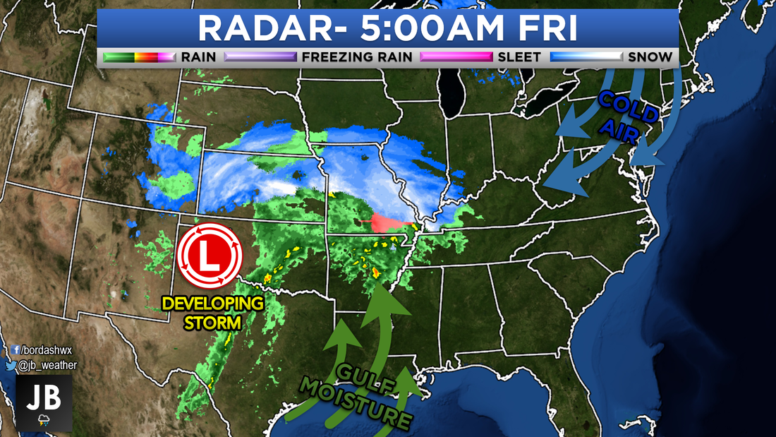 There is a weak northern piece of energy with this system. It is hard to tell, but that is helping in enhance those snows in the Midwest. That weak northern piece will start to race out ahead from the main storm. It will be that fast moving piece of northern energy that will bring the Mid-Atlantic an inital snow threat on Saturday. Generally, light snow will fall while the southern system tries to catch up. This is when northern areas could see a majority of their snow. I have that shown below with future radar stopped late Saturday afternoon. While some snow is possible, I do not expect much to fall in Southern Maryland and Tidewater Virginia on Saturday. 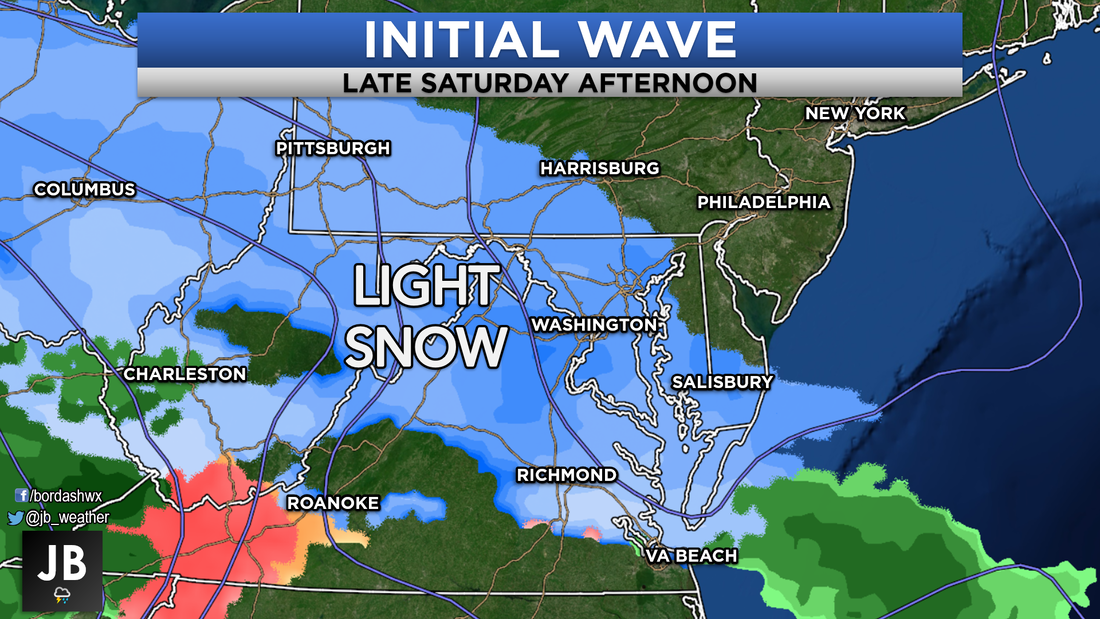 It will be that main southern piece of energy that will deliver most of the snow to southern zones. The southern storm will begin to take over during the overnight hours of Saturday. By Sunday mid-morning, snow will be falling across the region. The heaviest and more moderate snows will be focused across Southern Maryland. That all is shown in the image below. In a change from yesterday's forecast, this system does appear that it will come a touch further north. That will allow for some heavier snow, thus the higher totals. 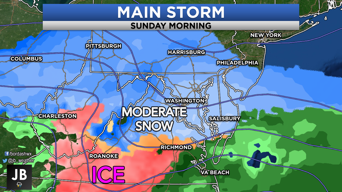 Most areas of sleet and ice should be confided to Virginia. I believe that the high pressure to our north will keep our area cold enough for snow. The only concern I would have for some sleet would be across Tidewater Virginia and extreme southern St. Mary's County (south of Great Mills). Even that wouldn't happen until late. Shown in the planner below, this should be all snow, with the biggest impacts focused on Sunday. 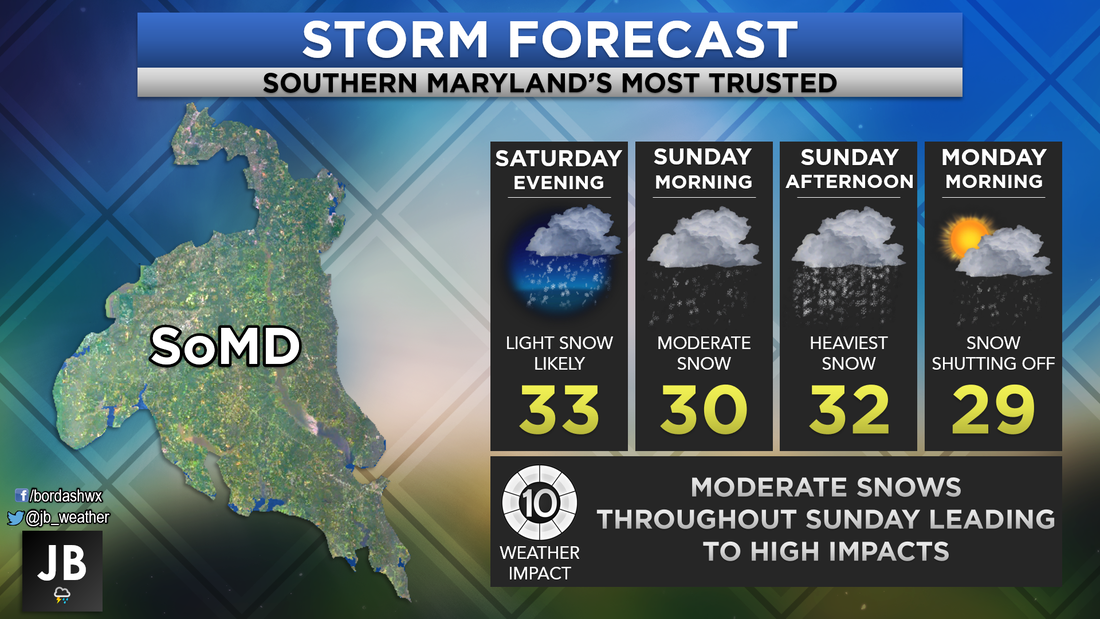 The impact from this storm looks to be moderate to high for our region, as shown below. The big question I know is coming is, "How will this effect operations on Monday?" School Odds will be released Sunday evening. However, impacts could linger into Monday, namely with travel. This will be the prominent across our region. Delays and closings are certainty possible on Monday from lingering impacts. Again, I will release more specific county-by-county school odds on Sunday. 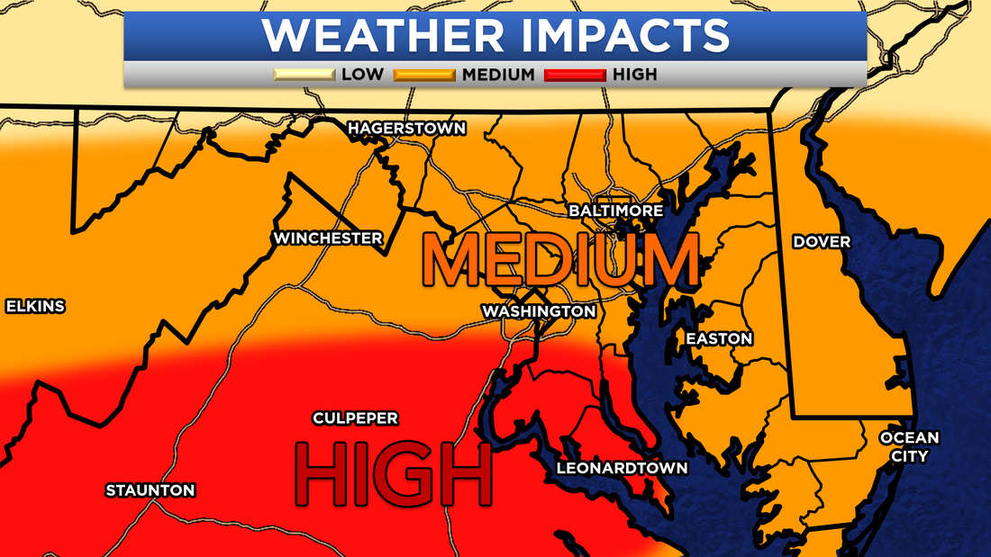 My-oh-my how this forecast continues to change. Just from yesterday, the snowfall forecast has increased for our region. I had mentioned yesterday that these southern systems do have a history of ticking north to give us some higher totals. Sure enough, that appears to be the case. Southern Maryland looks to be game on for some significant snow totals and impacts Sunday. I will continue to monitor this storm, and make any adjustments to my forecast as I see fit. However, I think this should be pretty close to my final call on this storm. I will have non-stop coverage on Facebook and Twitter to keep our community prepared and head of the storm. Stay with Southern Maryland's Most Accurate forecaster for updates!
Lead Forecaster -John A. Bordash
5 Comments
Nam
1/11/2019 02:37:45 pm
Thank you JB!
Lynn Deseve
1/11/2019 02:50:41 pm
Thanks your forecast seem to be right on!
Steve V
1/11/2019 07:04:00 pm
Thank you for stretching your graphic further east into DE. We’ve missed your forecasting since we moved from Calvert to Laurel DE.
Kim
1/11/2019 07:38:50 pm
Thank you so much! JB is who to follow Period! Spot on every tme
Mike R
1/15/2019 01:07:34 pm
I dont understand.....weather channel says rain and hoghs in upper 40s Leave a Reply. |
Archives
August 2020
Categories
All
|
 RSS Feed
