
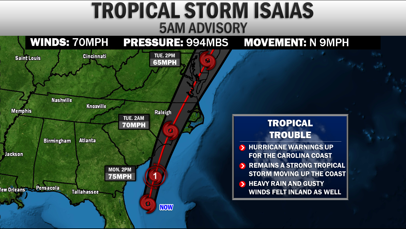
 Tropical Storm Isaias is still on par to move up the East Coast over the next couple of days. The 5AM Monday Advisory from the National Hurricane Center pegs Isaias as a strong Tropical Storm. Their forecast now shows Isaias strengthening back to a low-end CAT 1 Hurricane right before landfall this evening. Due to this, Hurricane Warnings are now up the Carolina coastline. The system is expected to gradually weaken after that point, moving along the Mid-Atlantic coastline as a moderate Tropical Storm. TROPICAL ALERTS 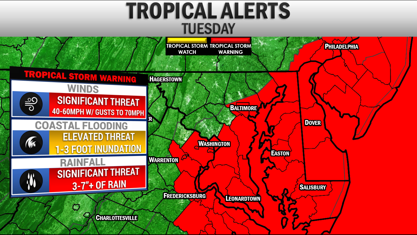 Tropical Storm Alerts have been hoisted for all of our region. Currently, Southern MD, the Delmarva, the Tidewater of VA, the DC/Baltimore metro areas, and our coastal waters are all under a Tropical Storm Warning.. This is where Tropical Storm force winds of 40mph or great are the most likely to start in the next 24-36 hours. EAST COAST THREAT 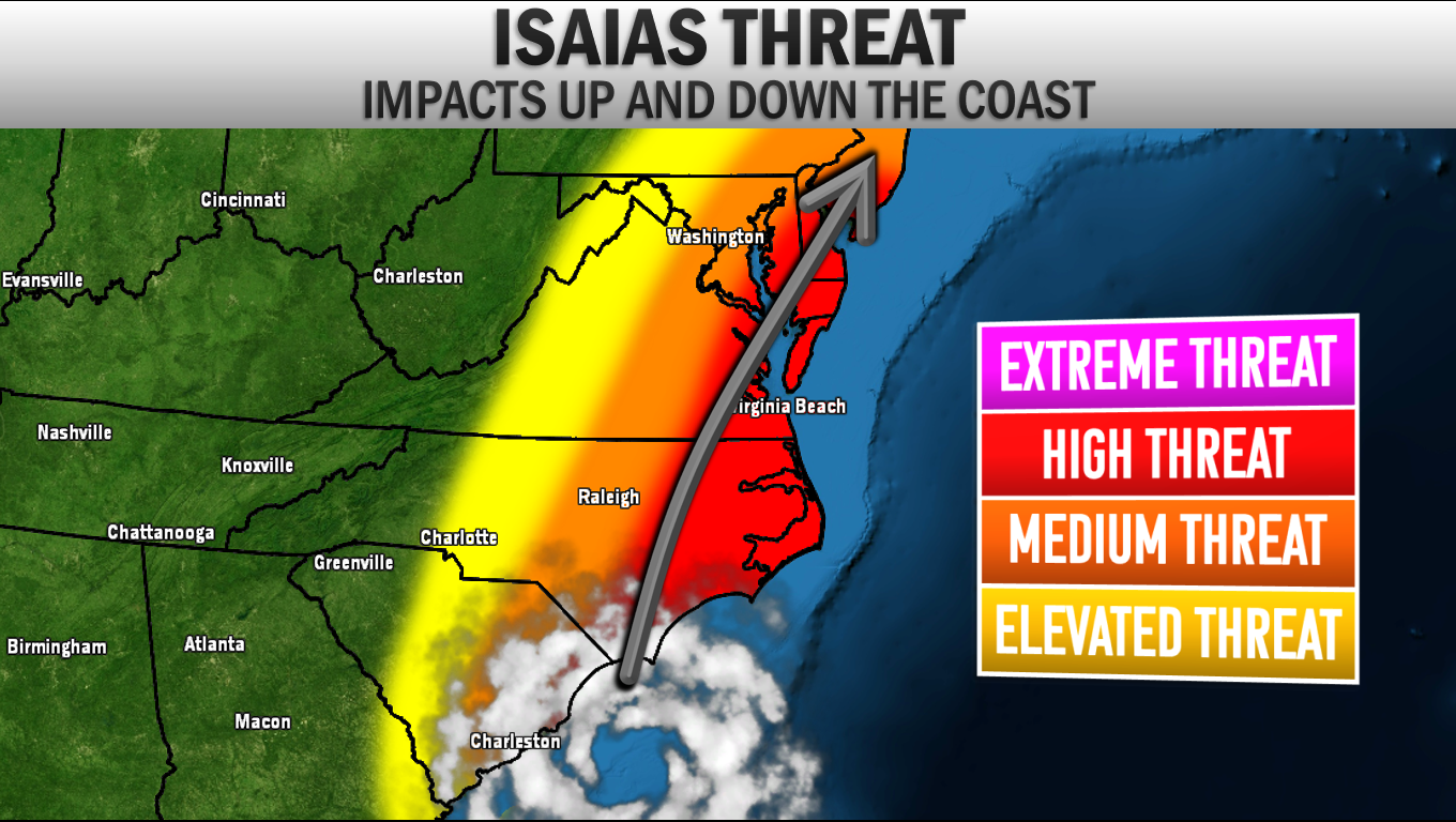 Isaias will be a threat up and down the East Coast. The highest impacts will be felt in the red shaded area. From the Carolina's to Tidewater VA and Coastal MD, tropical storm force winds, heavy rain, and some coastal inundation will all be impactful. The further away from the coast you are, lower the impacts. However, the heavy rain threat will extend well inland. FLASH FLOODING In my opinion, the biggest impact for the Mid-Atlantic will come from Flash Flooding. The Weather Prediction Center has placed our region under a rare SIGNIFICANT RISK (Level 3 of 4) of flash flooding for Tuesday. This shows that significant flash flooding is possible, especially for some of our most prone communities. If you have a basement, it would not be a bad idea to move items out of it in the event that a flash flood occurs in your area. 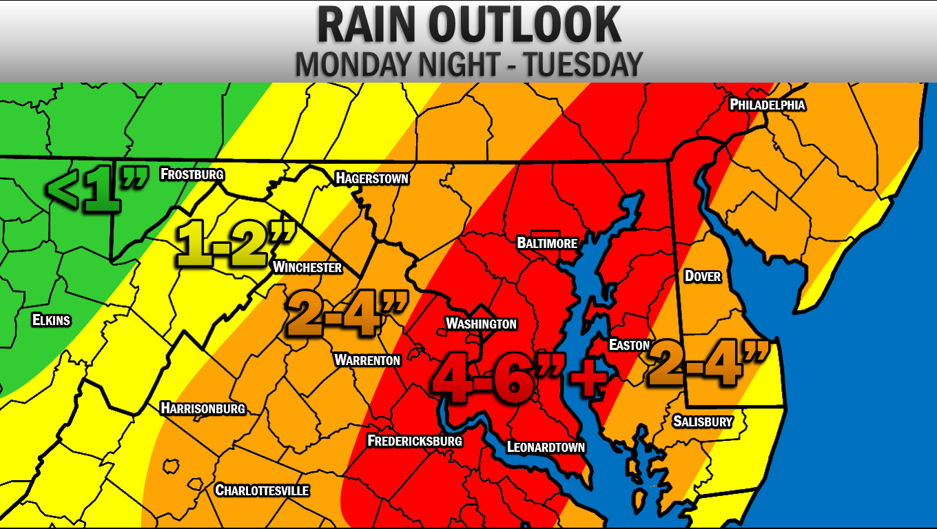 The flash flooding risk will be due to the high amount of rain we will see over the next 48 hours. I have increased my rain forecast since yesterday. I am now expect 4-6" to fall along and east of I-95, with locally higher totals possible. These rain amounts, even the 2-4" and 1-2" amounts, are no joke. This amount of rain, in such a short period of time will cause issues. Thunderstorms are possible this afternoon and evening due to a cold front moving through. The outer band of Isaias will begin to move in late tonight, likely after midnight. The worst of the storm will likely be from 9am-3pm Tuesday with heavy rain and high winds. WIND POTENTIAL 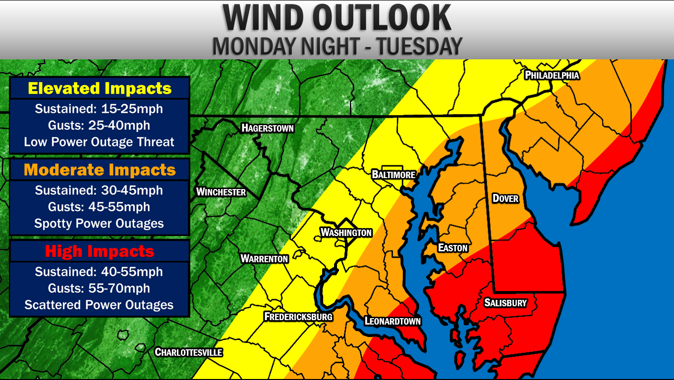 Even though this system will likely not be a hurricane by the time it reaches our area, we will still see high wind impacts. The highest impacts from the wind will locally be felt in Southern Calvert and Southern St. Mary's County along with the lower Eastern Shore and the Tidewater of VA. Here, winds are likely to be sustained at 40mph of greater during the peak of this storm, with gusts getting as high as 55-70mph. This will lead to scattered power outages and some downed trees. The power outage situation will likely NOT resemble some past storms like Hurricane Irene and Isabel. Those were strong storms with higher winds. Wind will not be the main threat here, but it will be impactful. Further inland winds are likely to be sustained between 30-45mph with gusts up to 45-55mph. Spotty power outages and a couple of downed trees will be possible here, but the threat is lower here. Back along I-95, winds are likely to be sustained at 15-25mph with gusts up to 40mph. COASTAL FLOODING 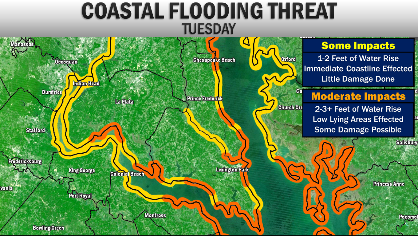 Another area that we are likely to see impacts from is coastal flooding. Shown above is my threat analysis from Isaias. The more moderate coastal flooding impacts will be felt along the coves, islands, back bays/rivers, and inlets. 2-3 foot coastal water rise is possible in these regions. These are the areas that are typically the most prone. I am not expect a mass storm surge event for Southern MD, and even in the orange shaded areas damage will be low. But these are the areas that could see coastal roadways flood and inundation along low lying areas. Chesapeake Beach, Calvert Beach, Cove Point to Solomons, Point Lookout, Piney Point/St. George, Clements/Brenton Bay/Avenue, Cobb Island, and Port Tabacco are likely to see these impacts. Elsewhere, 1-2 feet of water rise will be possible. TORNADO THREAT 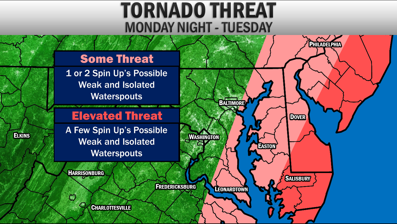 The tornado threat, especially in our region, will not be high. However, we do have a non-zero threat of seeing a weak spin-up or two. The highest tornado threat will be to our east along the Delmarva. I am not expecting a lot of tornadoes from Isaias. However, this will be something that we do need to watch. Waterspouts will likely be what we see across our region. IN SUMMARY Isaias will likely bring moderate to high impacts to our region. While this storm will not be on the same level as Hurricanes Irene and Isabel, this will be an impactful event. Here is the skinny of what you, in Southern Maryland, need to know:
Stay with JB Weather on Facebook and on Twitter for the latest information for Southern MD and Isaias forecasts. -John A. Bordash
0 Comments
|
Archives
August 2020
Categories
All
|
 RSS Feed
