
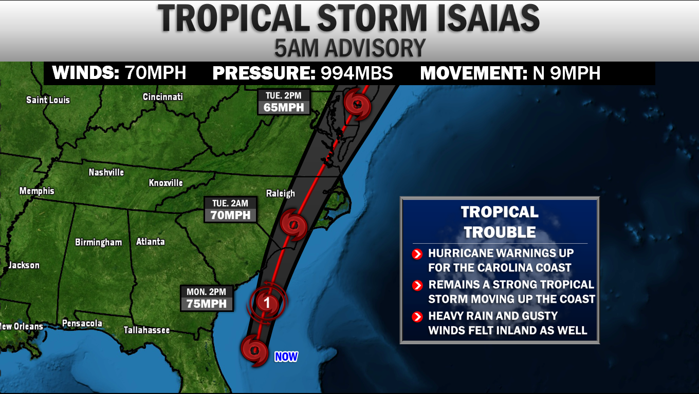
 Tropical Storm Isaias is still on par to move up the East Coast over the next couple of days. The 5AM Monday Advisory from the National Hurricane Center pegs Isaias as a strong Tropical Storm. Their forecast now shows Isaias strengthening back to a low-end CAT 1 Hurricane right before landfall this evening. Due to this, Hurricane Warnings are now up the Carolina coastline. The system is expected to gradually weaken after that point, moving along the Mid-Atlantic coastline as a moderate Tropical Storm. TROPICAL ALERTS 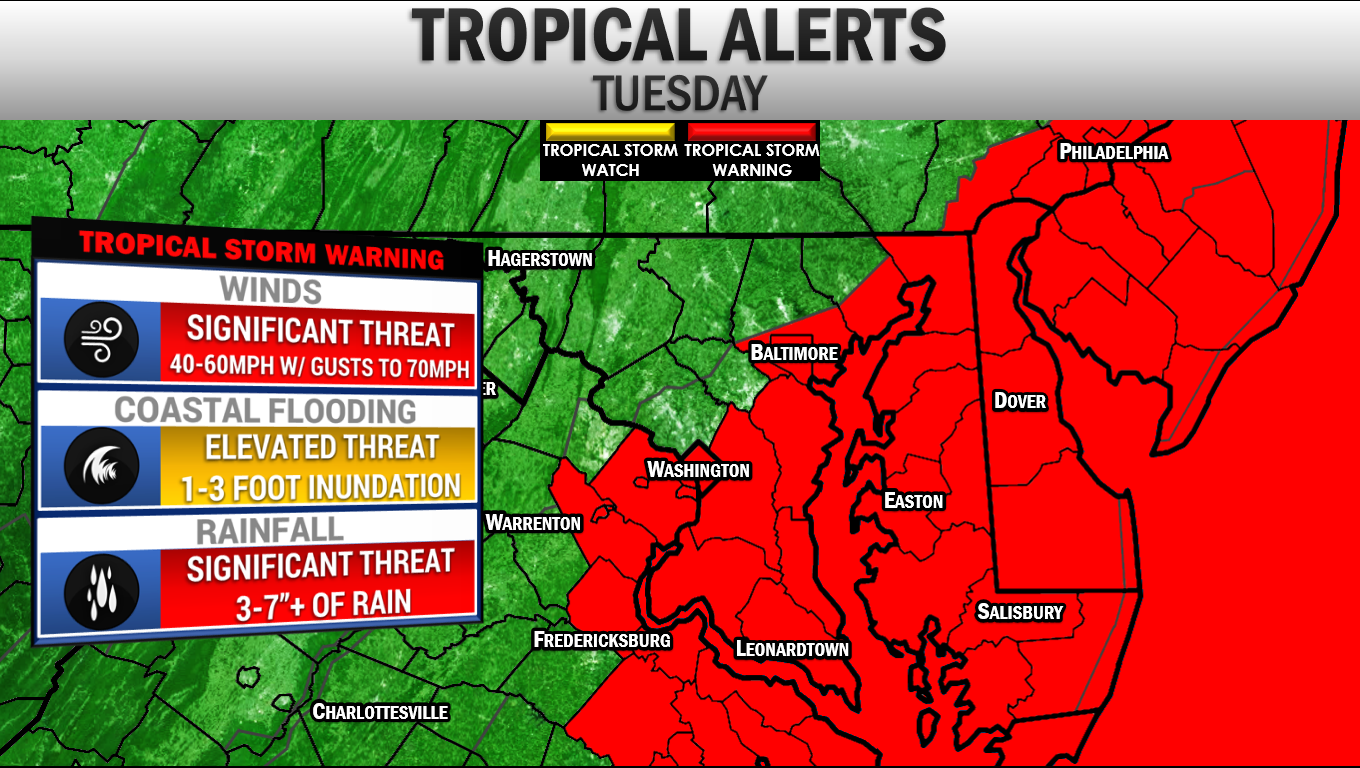 Tropical Storm Alerts have been hoisted for all of our region. Currently, Southern MD, the Delmarva, the Tidewater of VA, the DC/Baltimore metro areas, and our coastal waters are all under a Tropical Storm Warning.. This is where Tropical Storm force winds of 40mph or great are the most likely to start in the next 24-36 hours. EAST COAST THREAT 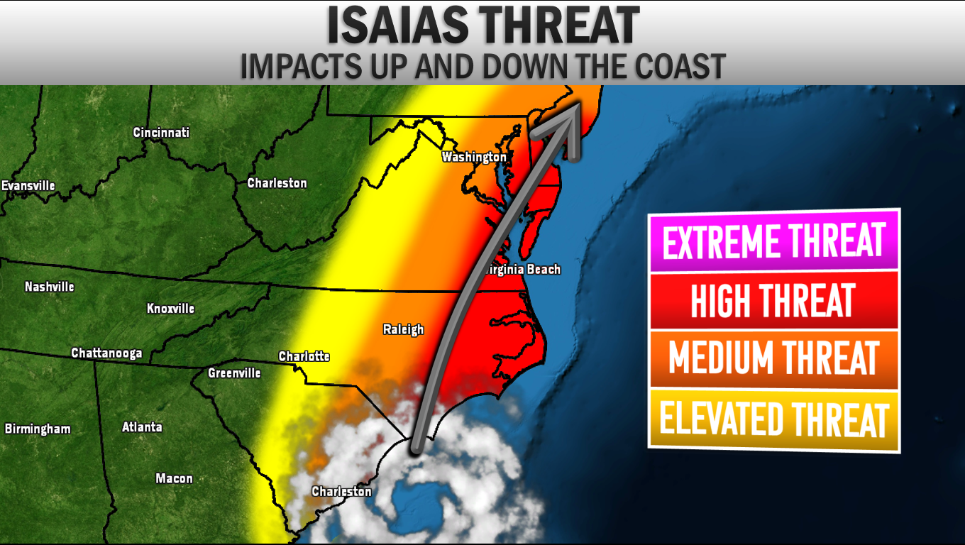 Isaias will be a threat up and down the East Coast. The highest impacts will be felt in the red shaded area. From the Carolina's to Tidewater VA and Coastal MD, tropical storm force winds, heavy rain, and some coastal inundation will all be impactful. The further away from the coast you are, lower the impacts. However, the heavy rain threat will extend well inland. FLASH FLOODING In my opinion, the biggest impact for the Mid-Atlantic will come from Flash Flooding. The Weather Prediction Center has placed our region under a rare SIGNIFICANT RISK (Level 3 of 4) of flash flooding for Tuesday. This shows that significant flash flooding is possible, especially for some of our most prone communities. If you have a basement, it would not be a bad idea to move items out of it in the event that a flash flood occurs in your area. 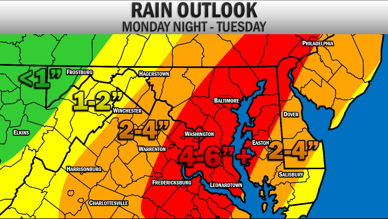 The flash flooding risk will be due to the high amount of rain we will see over the next 48 hours. I have increased my rain forecast since yesterday. I am now expect 4-6" to fall along and east of I-95, with locally higher totals possible. These rain amounts, even the 2-4" and 1-2" amounts, are no joke. This amount of rain, in such a short period of time will cause issues. Thunderstorms are possible this afternoon and evening due to a cold front moving through. The outer band of Isaias will begin to move in late tonight, likely after midnight. The worst of the storm will likely be from 9am-3pm Tuesday with heavy rain and high winds. WIND POTENTIAL 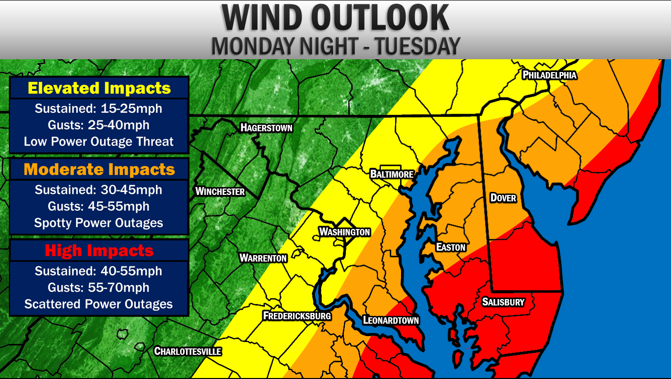 Even though this system will likely not be a hurricane by the time it reaches our area, we will still see high wind impacts. The highest impacts from the wind will locally be felt in Southern Calvert and Southern St. Mary's County along with the lower Eastern Shore and the Tidewater of VA. Here, winds are likely to be sustained at 40mph of greater during the peak of this storm, with gusts getting as high as 55-70mph. This will lead to scattered power outages and some downed trees. The power outage situation will likely NOT resemble some past storms like Hurricane Irene and Isabel. Those were strong storms with higher winds. Wind will not be the main threat here, but it will be impactful. Further inland winds are likely to be sustained between 30-45mph with gusts up to 45-55mph. Spotty power outages and a couple of downed trees will be possible here, but the threat is lower here. Back along I-95, winds are likely to be sustained at 15-25mph with gusts up to 40mph. COASTAL FLOODING 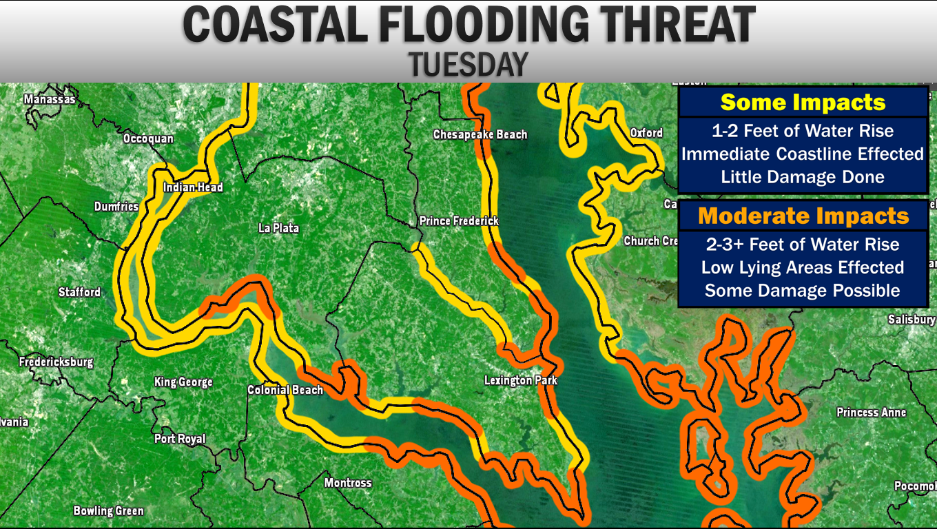 Another area that we are likely to see impacts from is coastal flooding. Shown above is my threat analysis from Isaias. The more moderate coastal flooding impacts will be felt along the coves, islands, back bays/rivers, and inlets. 2-3 foot coastal water rise is possible in these regions. These are the areas that are typically the most prone. I am not expect a mass storm surge event for Southern MD, and even in the orange shaded areas damage will be low. But these are the areas that could see coastal roadways flood and inundation along low lying areas. Chesapeake Beach, Calvert Beach, Cove Point to Solomons, Point Lookout, Piney Point/St. George, Clements/Brenton Bay/Avenue, Cobb Island, and Port Tabacco are likely to see these impacts. Elsewhere, 1-2 feet of water rise will be possible. TORNADO THREAT 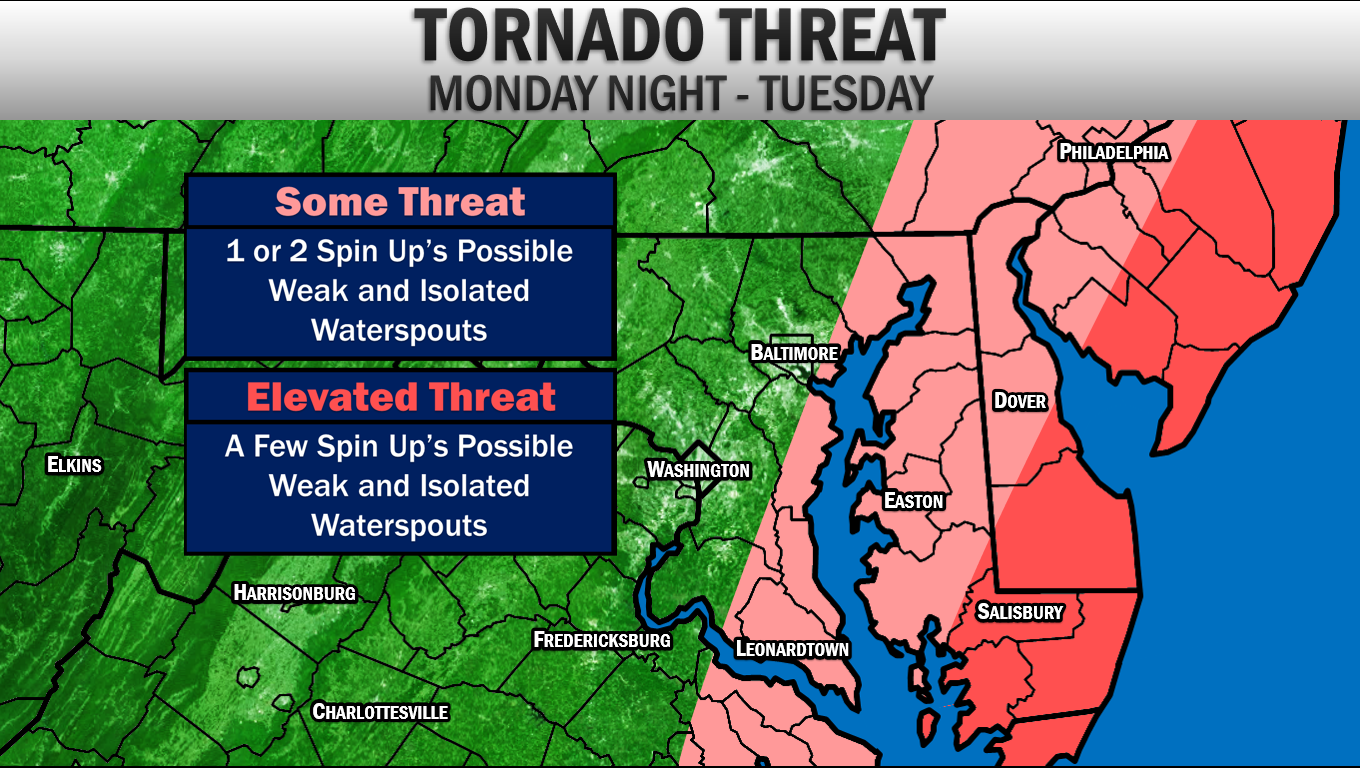 The tornado threat, especially in our region, will not be high. However, we do have a non-zero threat of seeing a weak spin-up or two. The highest tornado threat will be to our east along the Delmarva. I am not expecting a lot of tornadoes from Isaias. However, this will be something that we do need to watch. Waterspouts will likely be what we see across our region. IN SUMMARY Isaias will likely bring moderate to high impacts to our region. While this storm will not be on the same level as Hurricanes Irene and Isabel, this will be an impactful event. Here is the skinny of what you, in Southern Maryland, need to know:
Stay with JB Weather on Facebook and on Twitter for the latest information for Southern MD and Isaias forecasts. -John A. Bordash
0 Comments
10. Tropical Storm Lee Flooding (Sept. 2011)  The Fall of 2011 was a very wet one. This is highlighted by the remnants of Tropical Storm Lee. After the weak tropical system made landfall along the Gulf Coast, the storm moved inland, towards the Plains. However, the storm got "stuck" as atmospheric blocking prevented the storm from moving much. The results was an onslaught of moisture that got spread across the Mid-Atlantic and Ohio River Valley. While our region saw more than half a foot of rain, Charles County was hit especially hard. A widespread 10-15" of rain fell across the county, with areas near Allens Fresh recording over 15". Additionally, a couple of quick spin-up tornadoes formed throughout the region, sending school systems in a frenzy. 9. Record Setting Heat Throughout the 2010s 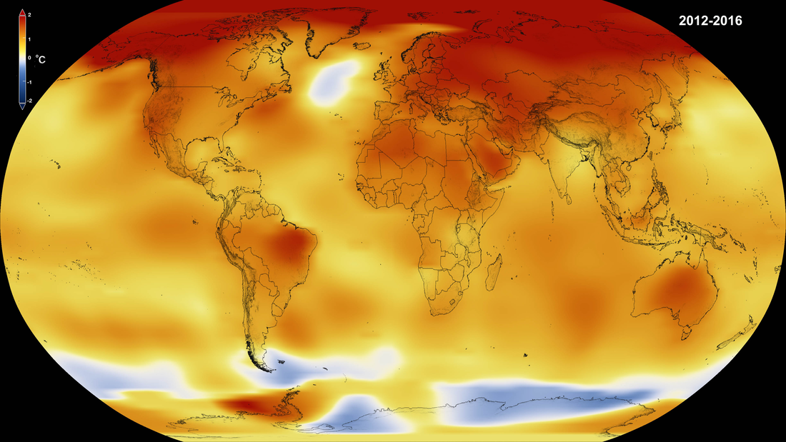 The 2010s will be remembered for a few things in the meteorological world. "Hot" will definitely be one of the words used when talking about the decade. The summers of the decade each seemed to get hotter, with more and more record highs getting set each year. 2010 saw the highest numbers of 90° days in modern history for the DC area, with 67 days reaching 90° or above. The intense heat was also felt during the summers of 2011 and 2012. In 2012, DC reached 100° or better 8 days. 8. Snowquester (Mar. 6, 2013) 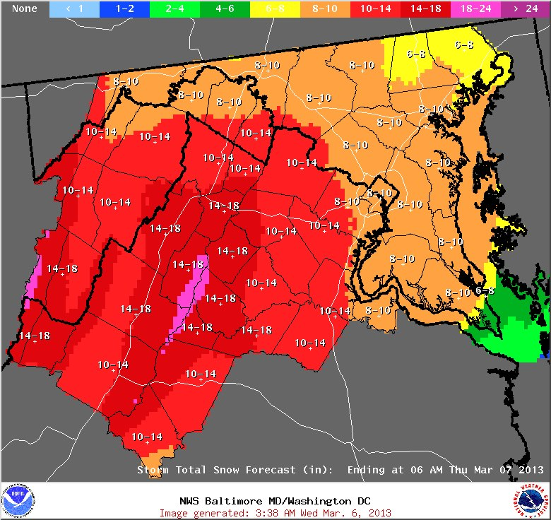 Snowquester makes it in to the Top 10 largely for what it didn't do. The Winter of 2012-13 was a snowless one for DC. Up until March, DC had failed to record 1" from any one storm. However, an impending storm in the beginning of March had looked to change that. In the midst of the Sequester crisis on Capitol Hill, this storm took on a similar name as it was expected to have big impacts. 8-12" of snow was forecasted for the region-- essentially a season's worth of snow. However, this forecast went horribly wrong. With warmer temperatures, and strong onshore flow, DC's Reagan National only recorded 0.2" of snow from the storm. This forecast was one of the worst forecasted storms in recent history, and not one that many local forecasters will forget. 7. Hurricane Sandy (Oct. 28-30, 2012) 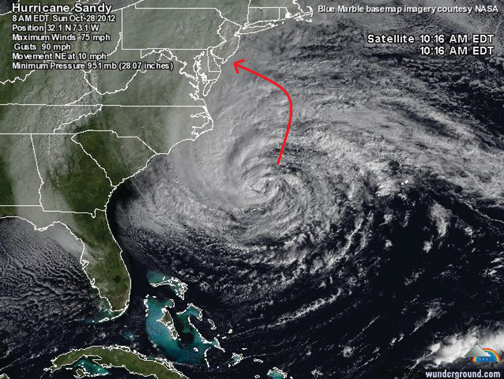 Thus far, the "Storm of the Century" has been Hurricane Sandy (albeit that might change seeing as we still have 80 years left in the century). This storm was quite abnormal. While moving out to sea, this storm took an unprecedented left turn right into the Jersey Shore. Widespread devastation was felt up and down the Northeast and Mid-Atlantic coastlines. The hurricane merged with a winter-like upper level low as it moved on shore causing an all out blizzard in the Mountains of MD, WV, and PA. If we were in New Jersey, this storm would easily have been the biggest weather story of the decade. However, impacts were not as serious here in SoMd like we had seen from prior storms. Nevertheless, do to the damage we did see, schools were closed for 2-3 days as the clean-up process began. 6. The Polar Vortex (Jan. 2014 & Feb. 2015) 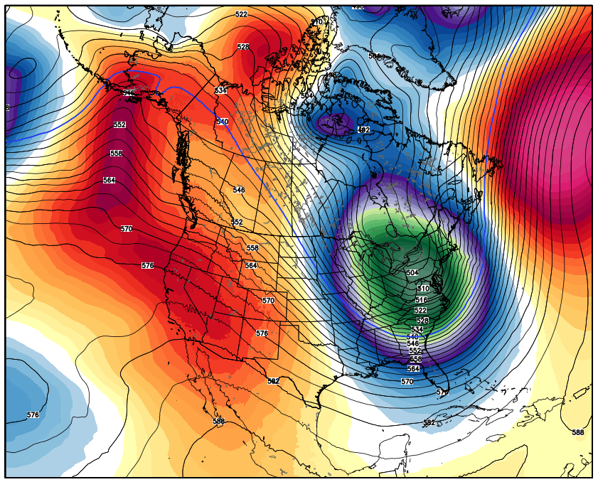 While the term "Polar Vortex" has been around for centuries, the term became big during the Winters of 2014 and 2015. During the latter half of these winters, a piece of Polar Vortex, from the Arctic North, got displaced. The displacement in the upper most levels of the atmosphere headed south, towards the Mid-Atlantic. During these two Polar Vortex outbreaks, temperatures plunged into the single digits and sub-zero for some. These bitterly cold outbreaks were enough to close area schools. 5. 2018 Record Setting Rain 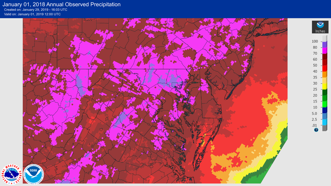 I'm sure many of you remember that it just did not seem to stop raining during 2018. It seemed like every couple of days, sometimes every day in the Summer, it was raining. The rain events were experienced were not just small events. Often times we would see 1-2" of rain a day. Local records were set as this was the wettest year on record. Many communities also saw devastating floods. This was the most evident for the communities in Northern Calvert County during the summer. 4. Hurricane Irene (Aug. 27-29, 2011) 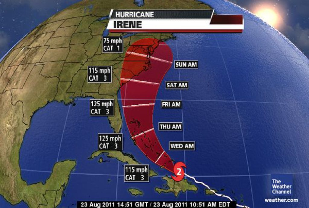 Hurricane Irene was the first hurricane many in our region had to deal with since Hurricane Isabel in 2003. The storm raced along the Bahama Island chain as a major hurricane. Many feared that the storm would maintain that strong intensity as it moved along the East Coast into New England. Thankfully, the storm did weaken as it moved northward. Nevertheless, our region in SoMd saw widespread damage as Hurricane Warnings were in effect. Many lost power for days, and area schools were closed for 3-5 days. 3. The Blizzard of 2016 (Jan. 22-23, 2016) 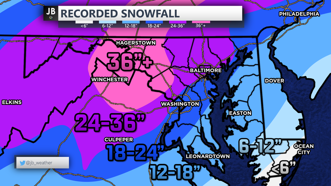 The Blizzard of 2016 came in what was otherwise a quiet year for snow lovers. Of the 22" of snow that fell in DC that winter, 17.8" came from this one storm. This storm was well forecasted a week out. Many in the Mid-Atlantic, from DC to New York, saw 1-2 feet of snow, with some areas in MD and PA seeing 3-4 feet of snow! Impacts were only moderate as the snow fell over the weekend. This was not a heavy wet snow, which made clean up easier. Nevertheless, area schools and the government were closed for the days following the storm. This storm sits as Baltimore's biggest ever with 29". 2. The Derecho (Jun. 29, 2012) 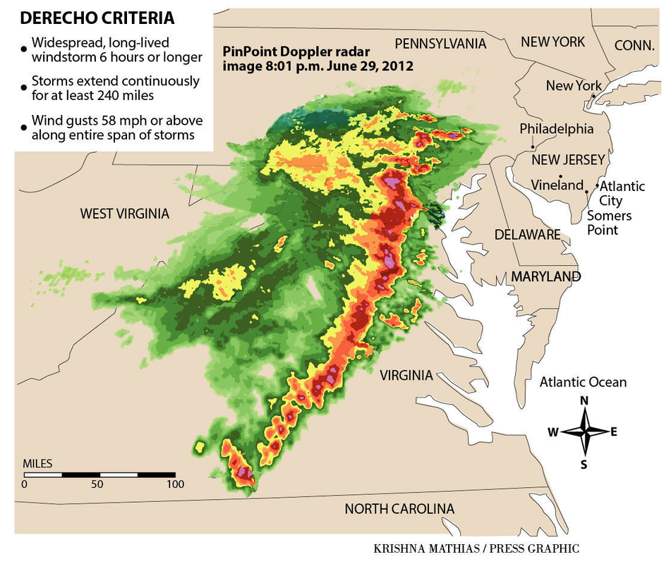 Say the word, "Derecho," to anyone in the DMV and they will have flashbacks to the 2012 Derecho. After hitting 104° that afternoon, a strong line of storms developed near Chicago, and raced towards our region. This quick and powerful line of storms left more than a million people without power across the DMV, which was in the midst of a heatwave. This line of storms packed 80-90mph winds, frequent lightning, and hail. Damage was widespread across the state. Power was not restored to some for about a week. 1. Snowmageddon (Feb. 5-6, 2010) 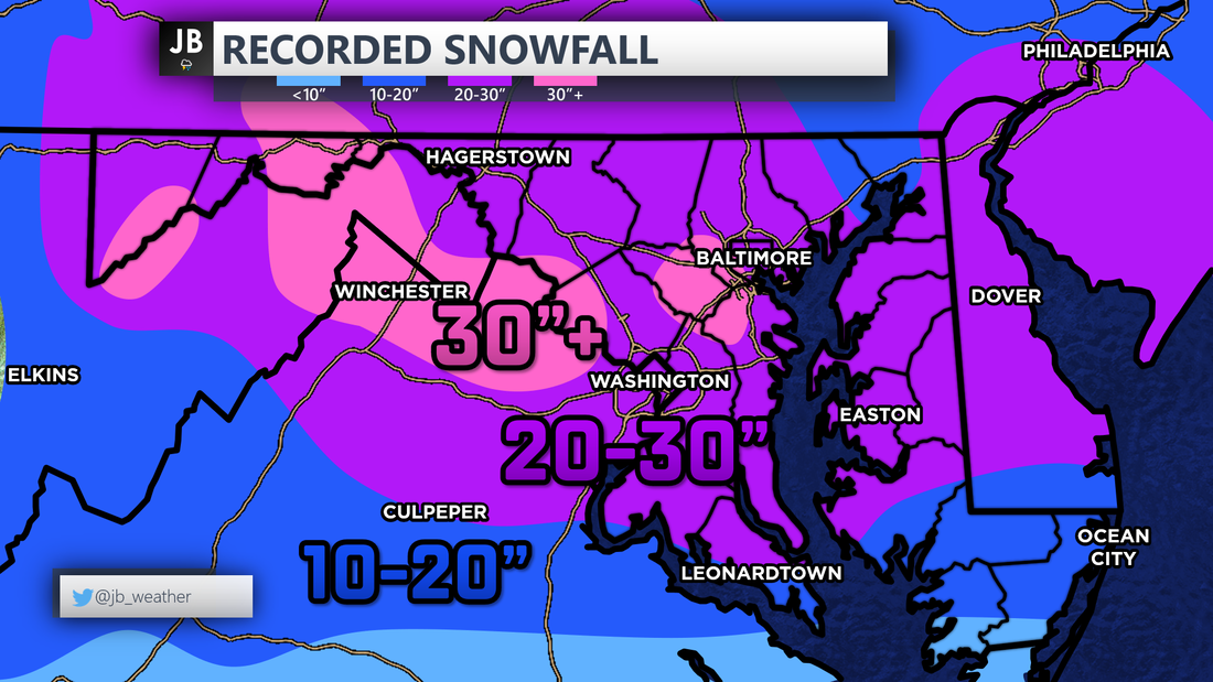 Finally, the biggest story of the decade-- Snowmaggendon. The Winter of 2009-2010 was a record setting one. Over 50" of snow fell in DC as 3 large-scale blizzards hit the region, along with a few other large 8-12" events. Getting just one blizzard for our area is hard, let alone three. What's more is that two of those blizzards happened within a week of each other. The first blizzard was in December of 2009, we then saw a 12"+ snowstorm (not a blizzard) hit SoMd at the end of January, then the blizzards in February. After this winter, area Superintendents were left applying for snow day vouchers as area schools were closed 10-20 days that winter. The biggest of the three blizzards was the February 5-6 storm. This storm dropped 20-30" of snow widespread across the area-- even in SoMd. With the rain/snow line suppressed well to the south, SoMd cashed in on the snow totals. The heavy, wet snow took a long time to clear. I was in 8th grade when this storm hit our region, and really perked my interest in the weather. I remember being out of school for a week and half from this storm. This blizzard, and this winter in whole, will be one that lives on for a long time in the history books!
Yet another storm system is threatening to bring wintry weather to the Mid-Atlantic. A storm system will move east across the country, before making a turn northward from the Gulf Coast region. How far north that system comes is the largest question. As shown above, we really have two scenarios. With scenario one, the storm would stay suppressed to the south. With that sort of a track, cold air would be allowed to dip further south into our region. As the precipitation spreads across the area late Sunday morning, it would be mainly snow. Some mixing would be possible for southern zones, but even there it would go over to snow. This type of a track would give our region some decent snow to close out winter. On the other hand there is scenario two, which I am favoring right now. Scenario Two would see our storm take a track further to the north. With a lack of cold air, warmer temps would be driven north giving most of the DMV a rainy Sunday afternoon. This scenario gives zones along the Mason Dixon Line and points north the highest snow totals. With still a degree of uncertainty, the National Weather Service has issued a Winter Storm WATCH for far northwestern areas. This is where the highest snow totals look to set up, locally. 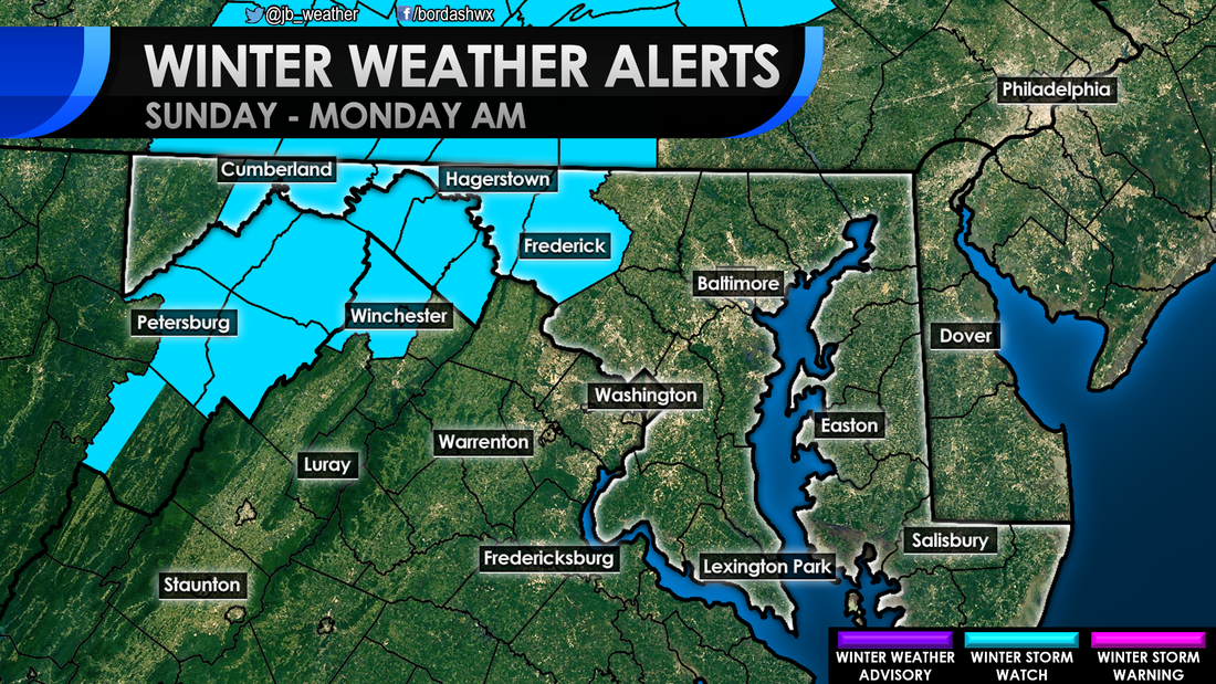 Again, at this juncture I favor a more northern track with this system. With that, I think most along I-95 and to the southeast see mainly rain. Areas along I-95 and to the northwest are likely to see some initial snow around noon (which is also when rain would start across SoMd) before going over to rain. I expect snow to hang on the longest where that Winter Storm WATCH is. 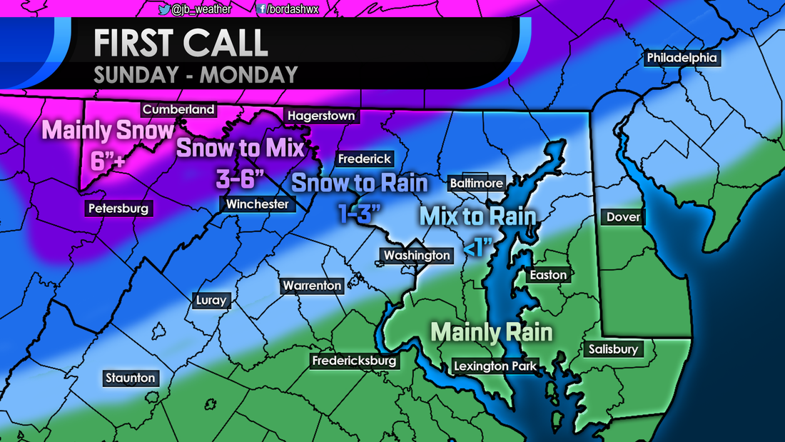 By and large, this looks to be a typical, I-95 north and west type of an event. It is very possible that this could be the last winter storm of the season, but we'll see how March plays out. Precip with this storm should break out around noon on Sunday. Areas NW of I-95 will transition to rain throughout the evening. It looks like all precip should be out by mid-morning on Monday
-John A. Bordash A weak system moving to our south is likely to spread light precipitation across the region tonight into tomorrow morning. Temperatures will be marginal, sitting within a couple degrees on either side of 32. This means a mix of snow, sleet, and rain is likely. Shown above is Futurecast timing this system out. Precip likely starts to overspread the area between 2-4am before shutting off around 10am. You can see that dry air works in, which may lead to some areas seeing close to nothing. Temps start to warm around 8/9am leading any snow/sleet to go over to rain for many. However, even rain should be done by late morning as dry air wins out. Where temperatures are colder, to the north, more of a snow/sleet mix is expected. Where it is warmer, points south of DC, it is likely to be more of a sleet/rain mix. Snow and sleet are the most likely to accumulate north of DC. Because it is warmer across southern zones I'm not expecting much snow, maybe up to inch for some. That snow is likely to be mixed with sleet. Any snow/sleet that accumulates will largely be in more rural zones, away from the water. The further south you go, the more likely you are to see a rain/sleet mix verses just snow. Below is my Final Call on snowfall.  This is not a big event by any stretch of the imagination. However, coming right before/during the AM commute could cause some problems. Impacts will be moderate for communities in Northern MD and Northern VA. Across Southern MD, the Delmarva, and Tidewater VA this may bring elevated impacts. Some traffic problems may be possible, especially on roads not treated.  What about schools? School closing odds increase the further north you head. However, I think many school systems will opt to delay. Some schools have a pre-planned 2-hour early dismissal, such as St. Mary's and Montgomery. Here, they may opt to have a delay instead of the half day. Nevertheless, I don't really see any county needing to close. Most of the winter weather should cut off around 8/9am.  Again, this is not a high impact event, especially for southern zones. Any winter weather should shut off by 8/9am. Some school and travel delays are possible during the early morning hours.
-John A. Bordash A weak system moving to our south late Thursday into Friday will usher in the chances of wintry weather across the region. This is all apart of what I view as Winter's Last Gasp. After the middle of next week, the pattern turns unfavorable for wintry weather. We will have a few shots of wintry weather until then. As mentioned before, the first one comes overnight Thursday. Shown above is Futurecast timing this system out. This system is not strong at all, so I'm not expecting heavy precipitation with this event. Nevertheless, a rain/snow mix will begin to move into far western zones around midnight. Temperatures across the region will continue to fall as the precipitation pushes eastward. With marginal temperatures south of DC, I'm not sure how much will fall as snow here. This looks to be just a sleet to rain event locally. However, once you head north of DC, it will be possible you can see a few hours of light snow. Shown below is the snowfall output from Futurecast. Remember, that is not my prediction. 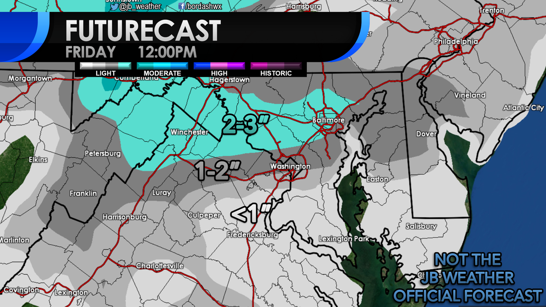 Where the precipitation stays mainly snow will be where the higher totals are. It looks like the favored zone with this event will be in a thin area from the northern DC beltway to the Mason Dixon Line. South of there, it is likely to be a snow/sleet/rain mix. Marginal temperatures will make it hard for snow to accumulate across this zone. Across the Tidewater of VA, to southern St. Mary's County, and the southern Delmarva, this looks to be a mainly rain event. Some sleet is possible here, but I do not think it will be much. Shown below is a depiction of who should see what type of precipitation and my First Call on snowfall. 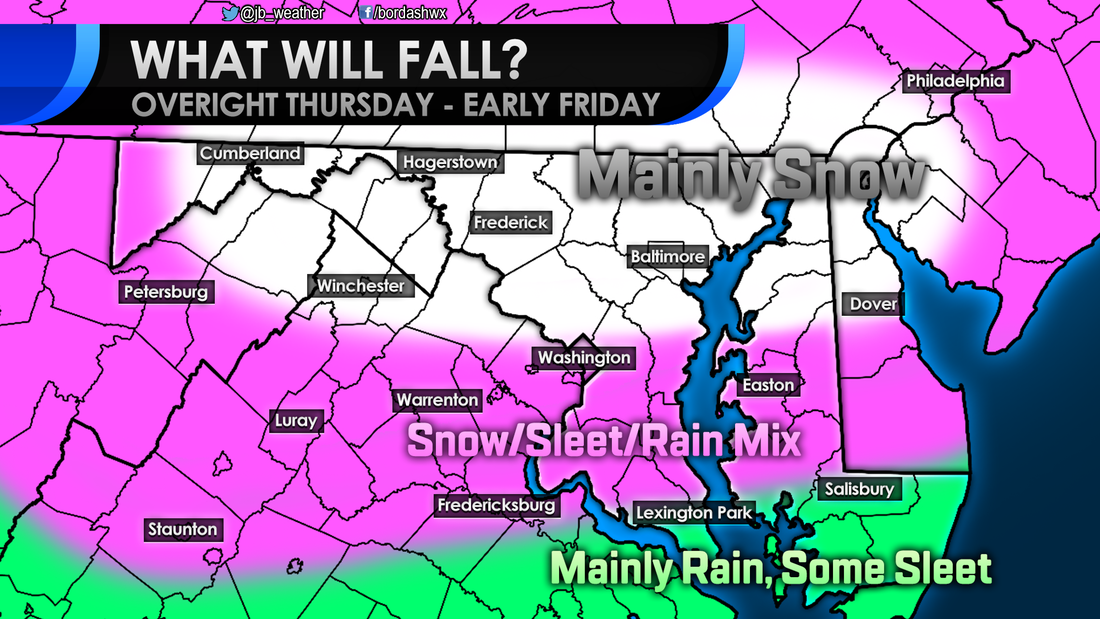 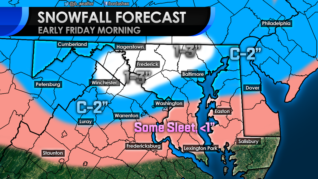 C-2" means a Coating to 2" By and large, I am not expecting a high impact event for anyone. These are rather low totals, that should fall overnight. However, the one problem here is timing. The mix of sleet and snow could have a moderate impact for northern areas Friday morning. Across Southern MD it is an Elevated impact. Some sleet could accumulate in colder locations and, "back roads." By-and-large though I am not expecting much. 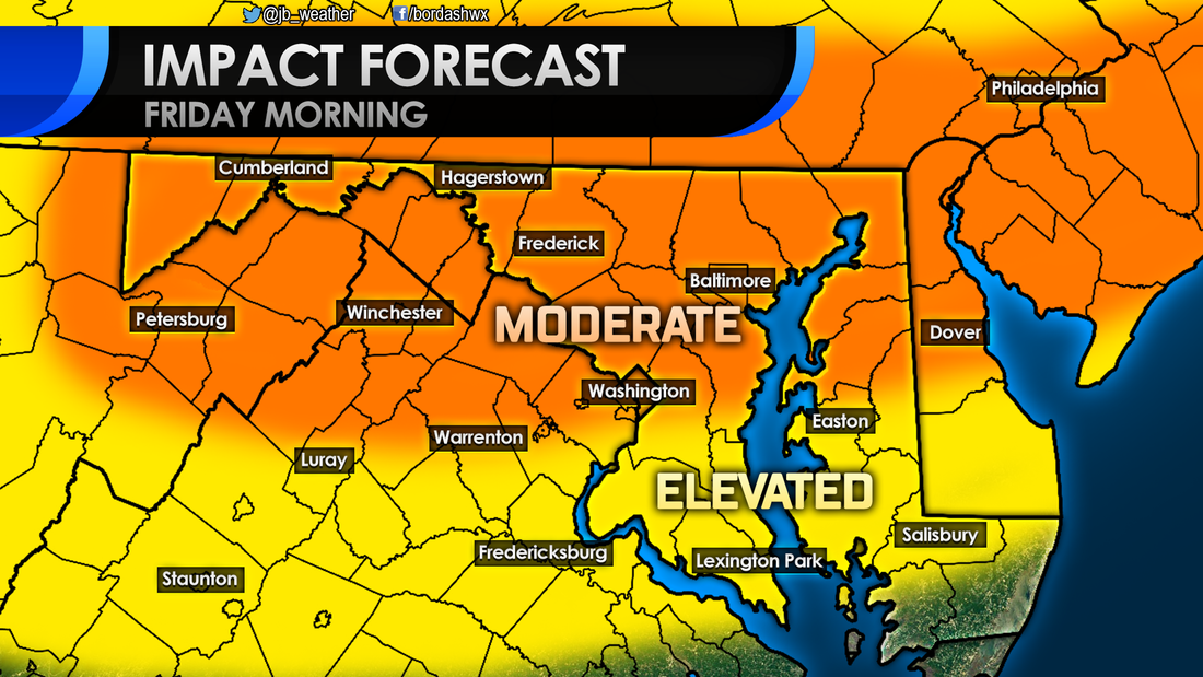 Moving forward, our next credible storm threat comes at the beginning of next week. A storm will move north from the Gulf Coast region. A high pressure to the north will dictate where this storm goes. If the storm take a track that's more to the north, warmer air will get pulled in and we will see rain across the Mid-Atlantic. If this storm takes a more southern track, we could see some wintry weather to kick off the week. There are a lot of variables at play, so not that much is known. This picture should be clearer by weeks end. 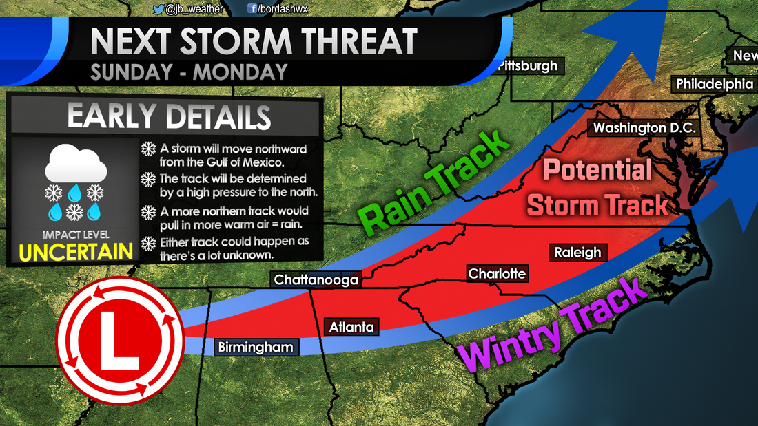 Needless to say, there is a lot to watch over the next few days. Up first will be this quick shot of winter weather overnight Thursday. I'm not expecting much snow or sleet to fall, but enough could fall at the wrong time to cause some school and travel delays. I'll be updating this forecast throughout the day tomorrow, stay tuned.
Lead Forecaster -John A. Bordash |
Archives
August 2020
Categories
All
|
 RSS Feed
