
|
Most would say this winter so far has been warm and rather wet. Actually, December 2015 was the warmest such month on record for Maryland. So far, we've also been snow and ice-free. This has left many to wonder if winter will ever come. Well the pattern heading our way this month will be making up for lost time. Things certainly are changing in the atmosphere from a warm and wet pattern to more of a cool and dry pattern in the Mid-Atlantic. As I’ve been talking about for most of this week, the pattern seems to be flipping to a more winter like one for January First Half of JanuaryFor the first half of the month, we're going to cool things back down to average. I expect for us to see shots of seasonable cool air (upper 30s and lower/mid 40s) and seasonally warm shots (40s and low 50s). We kick this pattern off this weekend and early next week, as pictured below. We may transition to some seasonable warm air for the middle and late portions of next week, followed by more cold. 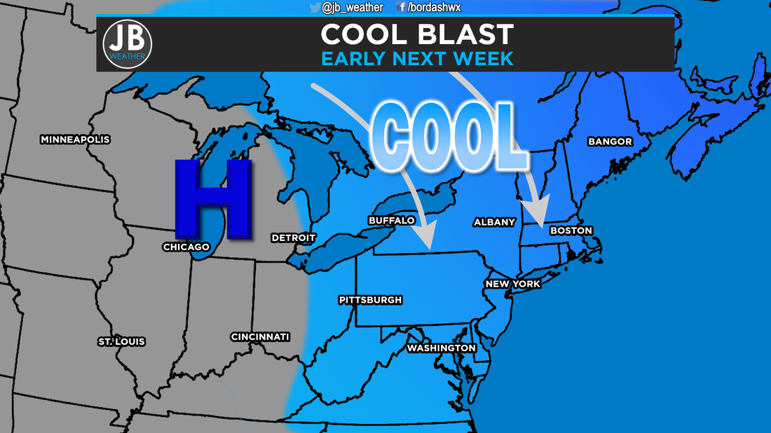 A high pressure system to our west looks to bring in some seasonably cool temps. What about snow? While I certainly can’t tell for sure if we will see snow anytime soon, I think the pattern is looking favorable for at least some chances. I definitely think we'll have more opportunity for something than we did in December. It looks like during the first two weeks in January, when we'll be cold enough snow, we'll be dry. On the flip side, when we're warm is when we'll see storms. I know, that is kind of aggravating, at least for snow lovers. However, I do think we'll see our first flakes sometime in the first two weeks of the month. I also think the potential could be there for a storm towards the middle of the month, but that’s all I’m willing to say about that, at least for right now Last Half of JanuaryI have low confidence in this part of the forecast. A persistent ridge of high pressure will dominate the west coast. Meanwhile on the east coast, a persistent trough of low pressure could keep things cold, but nothing like the last two winters. I could see more prolonged periods of cold air, which could mean a few days with daytime highs only in the 30s. What about snow chances? The chances of snow look to be about as high as I’ve seen them so far this season, which isn't saying much. It's still VERY early to talk about any specific storm but this is by far the best pattern for winter weather we have seen all season long. SummaryThe month of January as a whole looks to hold a wintrier set up than December ever did. It looks like we should finally see some shot of some cool air, with the potential for some colder shots for the second half of the month. Additionally, we may finally also have our first shots at some wintry type storms. We should see our first flakes in the first half of the month. We will have lots of potential this month, we'll just have to see if we can get the right players to come together at the right time. Stay with JB Weather for the latest weather information.
Lead Forecaster -John Bordash
0 Comments
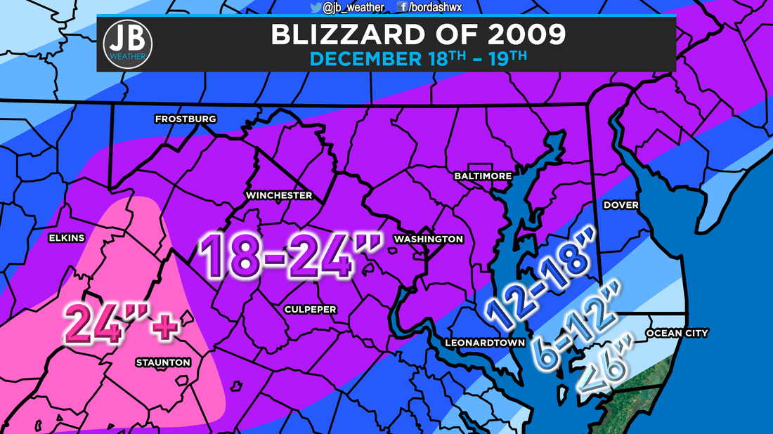 Final snow totals from the historic blizzard. These are general ranges, so it's possible that specific amounts were higher, or lower, than what is pictured. Six years ago the hype was building and grocery store shelves were emptied as one of the Mid-Atlantic's biggest December snowstorms on record hit the region. This storm was the first of three major storms that would hit Maryland during the 2009-10 winter. Most years, this type of a storm would have been a storm everyone remembered for years. However, this storm is often overshadowed by Snowmageddon (Feb 4-5) and Snoverkill (Feb 9-10) later that same historic season. Let's take some time to revisit this historic storm. 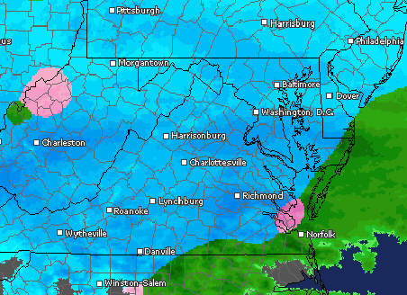 Radar imagery during the midst of the blizzard. In the days leading up to the blizzard, the overall pattern and model guidance suggested the potential for a storm. However, it was not until 24-36 hours before the first flakes did it become clear this would be a major storm. Initial forecasts from the National Weather Service called for a 5-10" snow. From there, forecasts quickly escalated to 12-24". The National Weather Service was quick to issue Winter Storm Warnings for the Mid-Atlantic. During the storm, Southern Maryland got upgraded to a Blizzard Warning, the first in some time. A map of what the warnings looked like on December 18, 2009 is shown blow. 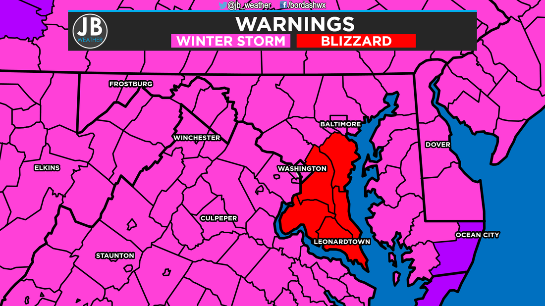 The National Weather Service issued a Blizzard Warning for Southern Maryland during the historic storm. The 16.4" of snow that fell at Reagan National Airport currently stands as the largest December storm on record. The historic storm also helped to set December 2009 as the snowiest December on record. Additionally, this storm stands as the 7th largest snowstorm on record. 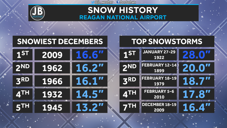 Most thought this was going to be the storm of the winter as the conditions that came together to produce this storm did so, perfectly. Little did many know, we were just getting started in what became the snowiest winter in history for our region. Below are some images from this snow event. |
Archives
August 2020
Categories
All
|
 RSS Feed
