
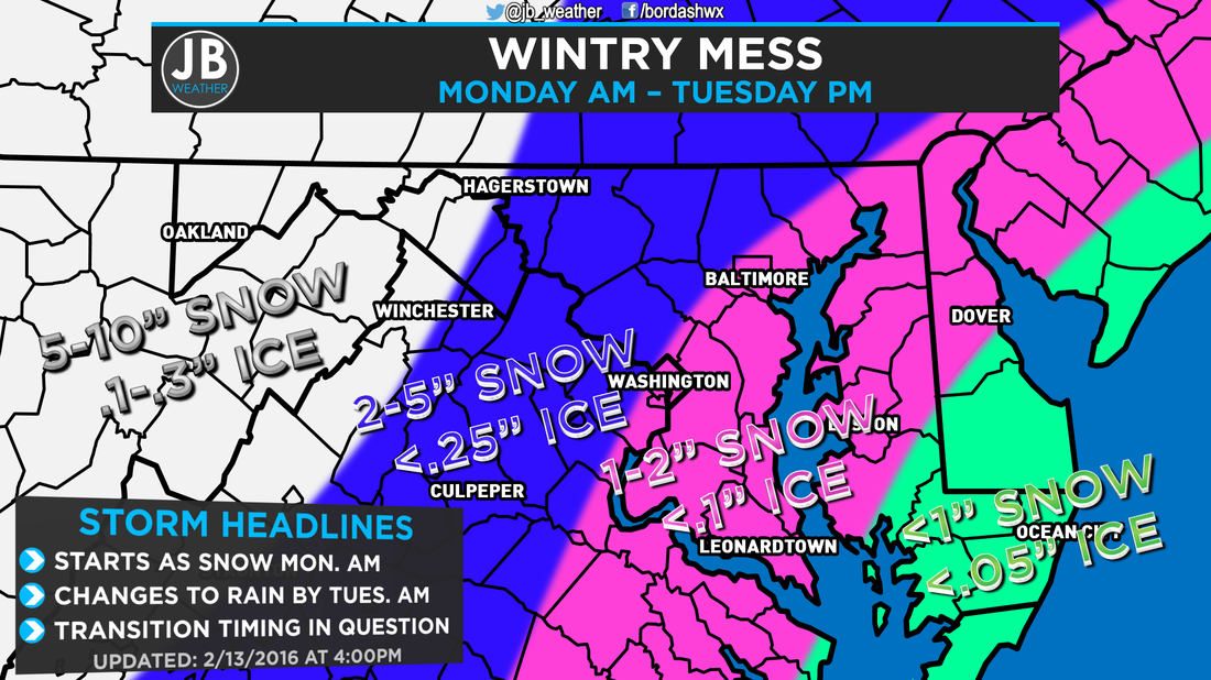
Next Chance of Accumulating Snow: Monday Probability of Accumulating Snow (1" or more): 60% Another wintry event is poised to strike the Mid-Atlantic, but this one will be just a bit different than other storms we've had to deal with so far this winter. Most of our storms have either been snow or rain with the concern of ice being virtually absent. Well, all good things must come to an end, and we're now tracking a storm that may bring an icy mix to Southern MD. Our cold air sets the stage for this storm. We're are going to be really cold this weekend. Temperatures have failed to go above 32 since Thursday, and lows tonight will be plunging into the single digits. This storm system will be coming as our cold air starts to move out. However, it is really hard to just displace cold air out of our region. As a result, shallow cold air (relative to the atmosphere) can get trapped here at the surface while the air above us is warming. When this happens, we have to start worrying about sleet and freezing rain, which can lead to ice accumulations. It appears that precipitation will start to breakout during the predawn hours of Monday morning as our storm pushes north. Temperatures will be in the 20s and upper teens, so whatever falls will be in the form of snow. The atmosphere will be cold enough to support snow until the afternoon hours of Monday. It's at that time that the upper levels of the atmosphere start to warm, and we will start to mix with sleet and eventually freezing rain from southeast to northwest. We will dealing with this wintry battle until the early morning hours of Tuesday. By then, the atmosphere should be "warm" enough to support plain rain, and we'd deal with rain until the afternoon on Tuesday. Temperatures Tuesday may max out in the upper 40s and lower 50s. I'm skeptical of how warm we get and how fast. It's very hard to dramatically warm temperatures during the nighttime hours while it's precipitating. Nevertheless, we will change to plain rain eventually. The further inland you are, the longer you will see wintry precipitation. It is for that reason that the National Weather Service has issued a Winter Storm WATCH for areas along, and west, of I95 where more snow and ice is possible. We will still have to deal with snow and ice southeast of I95, but not as much, hence why we are not under a Watch right now. 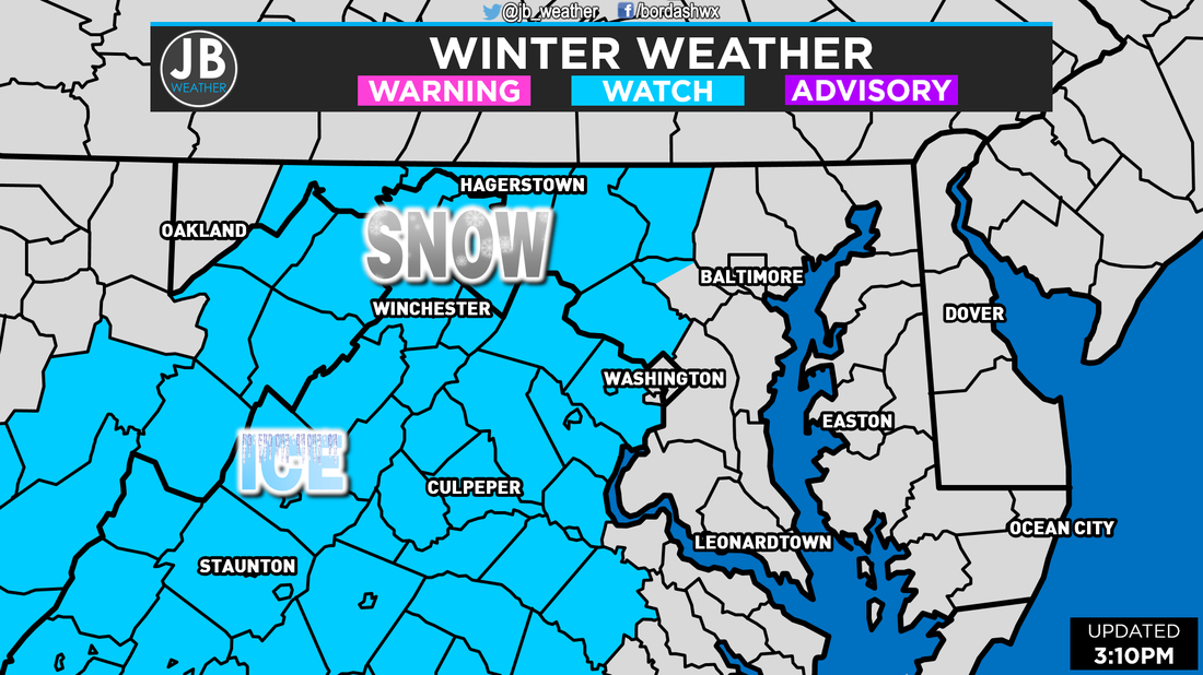 Winter Storm Watches as of mid-afternoon Saturday. These are set to take effect at 1am Monday, and last until 10am Tuesday. I am aware that many schools and business are closed on Monday for President's Day, but there are few places, including the College of Southern Maryland, that are scheduled to be open in full capacity. For those traveling or heading into work/school on Monday, I'd make an early call and say that those places will likely be closed, and travel could be impacted. Impacts may linger into Tuesday, but that will all be dependent on how long it takes for the wintry weather to transition over to rain. I am also tracking a small system that looks to move in behind this storm Tuesday night into Wednesday morning. It is still too early to speculate on that storm, but stay tuned.
 The Bottom Line is that we will have snow across the region Monday morning into Monday afternoon that will transition over to an Icy mix Monday evening, and eventually all rain by Tuesday morning. Any schools or business that are scheduled to be open on Monday will likely be closed and travel will be impacted. There are still a few questions on where the storm tracks, which then affects our temperatures, so snow/ice amounts have the potential to increase or decrease. RIght now this a medium confidence forecast, but we should know a lot more by this tomorrow, which is when I plan on releasing my final call. I am not expecting this to be a major snowstorm or ice storm. Stay with JB Weather on Facebook and Twitter for the latest information on this potential wintry mess.
Lead Forecaster -John Bordash
0 Comments
Leave a Reply. |
Archives
August 2020
Categories
All
|
 RSS Feed
