
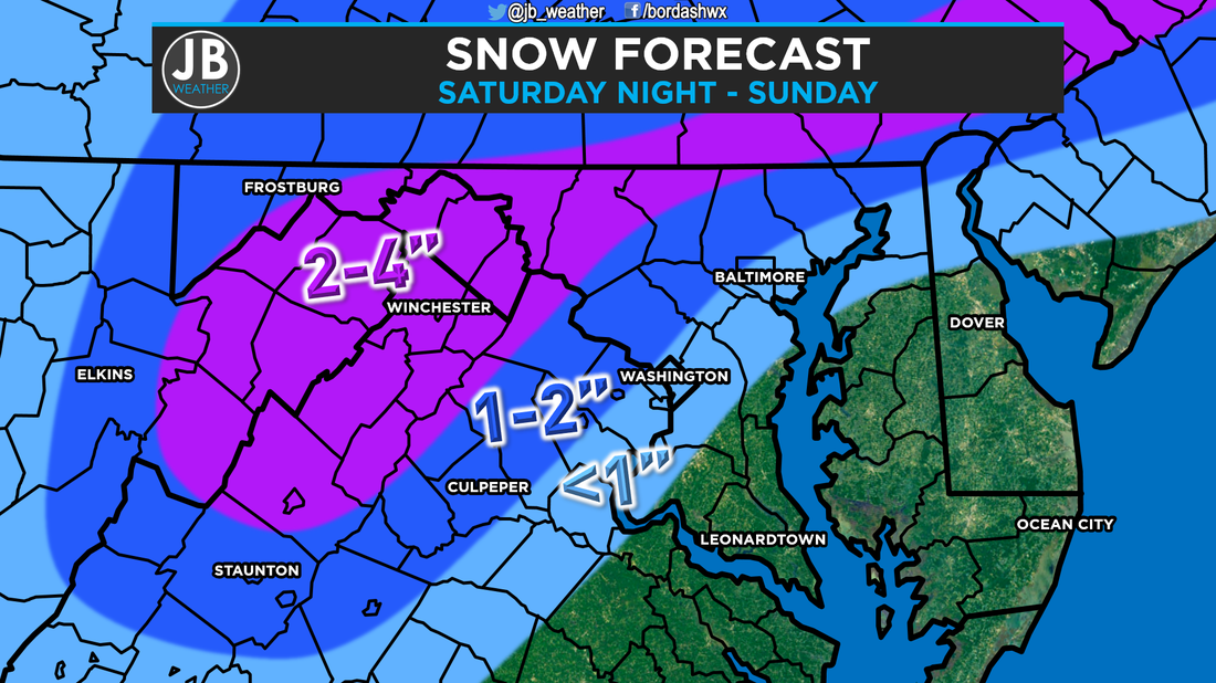
Next Chance of Accumulating Snow: Saturday Night - Sunday Probability of Accumulating Snow (1" or more): 20% Winter just does not want to go away! Over the past couple of days, some weather organizations have tried to advertise this storm as more than what it is. We're in Mid-March, accumulating snow gets really difficult. Unless the snow is falling at night, or it's falling hard during the day, the snow really has no chance at actually accumulating, even though it may be falling from the sky. Right now, it appears that we have an initial wave of precip that moves in around lunchtime on Saturday. For most of the region this will be all rain as temps get between 39-43. The only exception to that would be the high tops out in the mountains that may mix with some snow. Once the sunsets on Saturday, areas northwest of DC should transition over to snow, with that rain/snow line closing in on I-95. This is when those areas should get most of their accumulation, as SoMD stays all rain with temps remaining in the middle to upper 30s. On Sunday, areas northwest of I-95 should continue to see snow, but once the sunrises, not much more will accumulate other than what did so already. Later in the day on Sunday, mainly after 4pm, is when some of you in northern Calvert and Charles counties may start to mix with snow. Once the sunsets on Sunday, the storm will be pulling away from our area, but this would be our best shot in SoMD of seeing any snow. I think we at least have the chance to mix with some snowflakes before midnight, but very little (if any) will accumulate on the grassy surfaces. Below is a slideshow of how all of this should play out. Impacts from this storm will be rather minimal. This weekend will be wet and raw. Temps never get above 43 and most of the weekend will be spent either with precip falling from the sky, or with a mostly cloudy sky. Any outdoor activities will likely be rained out, but expect only wet roadways both days. Expect no impacts for Monday.  The Bottom Line is that this storm is going to be mainly a rain event here in Southern Maryland. Any snow that falls will do so Sunday around dinnertime, but even that probably won't accumulate. The past few events have over performed for SoMD, but I really don't see that happening this time. If anything, I could see this system being warmer than my current forecast. Nevertheless, I anticipate this being my only forecast for this storm. If something drastically changes overnight, I will update my forecast in the morning. Stay with JB Weather for continuing coverage throughout the weekend.
Lead Forecaster -John Bordash
0 Comments
Leave a Reply. |
Archives
August 2020
Categories
All
|
 RSS Feed
