
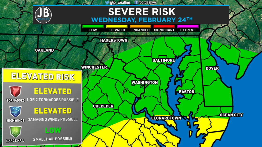
 Severe Risk map from the Storm Prediction Center for Wednesday, Feb. 24, 2016. The set-up for Wednesday looks to hold an elevated risk of strong to severe storms, along with a heavy rain threat. The severe threat will be dependent on how unstable, or warm, we get. The Flood threat seems to be much more likely at this point. Generally speaking, this is a setup I try not to get too excited about as a forecaster. Cloud cover and rain stabilize the atmosphere, which can limit the severe weather threat. The game we get to play tomorrow is: how unstable can we get the atmosphere? However, there have been plenty of times where we have been able to get some wicked storms with all day cloud cover and mist. The Severe Threat for tomorrow will be caused by an area of low pressure moving northward through the Mid-West. This storm system could actually give areas across Indiana and Michigan a decent sized snowstorm. However, we will not being deal with any wintry weather from this storm. As it pushes north, it will allow for temperatures to potentially soar into the 60s tomorrow afternoon and evening. Tomorrow may be a day where the actual high occurs around 7/8pm. Temps tomorrow will be dependent on how much cloud cover and rain we see throughout the day. The soaring temps will be due to the winds coming from the south. The winds above our heads will be racing. Those high winds aloft can help to create severe weather, and damaging winds within storms. However, we will not have too much energy, or what is referred to as CAPE, in the atmosphere to work with. This is called a "High shear, low CAPE" set up in the weather world. Below is our North American Model simulated radar for tomorrow evening. Don't take the simulated radar verbatim with storm placement and exact timing, but it does give us a few take aways. A few rain showers can be expected throughout the day. It looks like our threat for severe storms exists between 6pm and 12am as a line of storms works through. I think the model above may be just a tad too slow with moving that long through.
Because the atmosphere will be juiced up with moisture it appears that heavy rain, that could lead to flooding, will be our primary threat along with high winds. This set up also tells me that there is an elevated tornado threat, but the threat isn't too high. The better chance of tornadoes will be to our south, across southern Virginia and North Carolina. The Bottom Line is that some thunderstorms are possible tomorrow evening between 6pm and 12am. Heavy rain and high winds are the main threats with any storms that move through. There is also an elevated tornado threat, but it is not my primary concern. We will have rain showers and cloud cover throughout the day, which could help to prohibit the severe weather development. The Storm Prediction Center currently has portions of our region under an elevated risk for severe storms. However, I expect for them to place all of Southern Maryland under an elevated risk, tomorrow. You're going to want to stay with JB Weather for the latest forecasts and coverage if we do see storms tomorrow evening. Lead Forecaster -John Bordash
0 Comments
Leave a Reply. |
Archives
August 2020
Categories
All
|
 RSS Feed
