
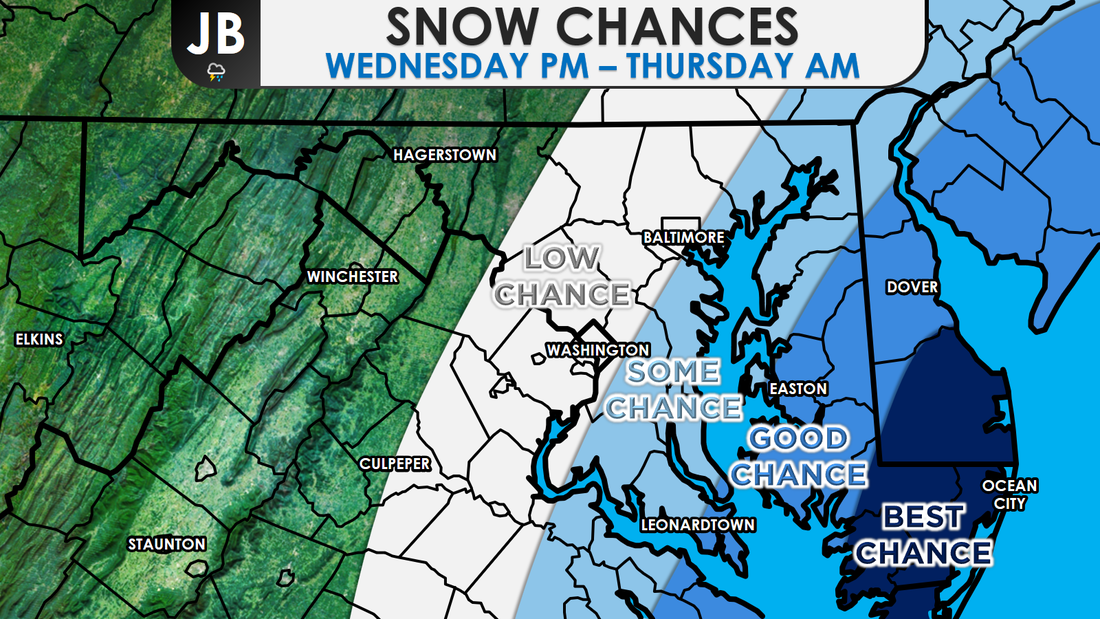
 Next accumulating snow chance: Wednesday Night Probability of accumulating snow (1" or more): 50% Model guidance this afternoon has shifted the track of the developing storm on Wednesday westward and closer to the coast. As a result, it looks like there is a better chance the region sees accumulating snow. This remains a very delicate situation where very modest shifts in the storm track could make the difference between no snow and a classic January snowstorm. An area of low pressure is forecast to develop near the Florida coast, and should track northward. As it does so, this system will get very strong. It is very rare to get storms in January as strong as this is forecasted to be. That is the part of the forecast that is pretty much nailed down. The questions currently surround the track of the system. Show below are our two possible scenarios.
Scenario One would lead to a moderate snowstorm for many south and east of I-95. On the other hand, Scenario Two would be just light, glancing blow that doesn't amount to much. Right now, both of these possibilities have a 50% chance of occurring. However, it is important to note-- more of our weather guidance has been shifting towards a Scenario One solution. It is safe to say that the probabilities for Scenario have gone up. Still a tad too early to say which track will happen, but we should know more after tonight's data comes in. With the way things stand now though, I'm starting to believe that a coastal track may be a more likely solution.
It is too early to say, with confidence, how much snow would fall, what area schools would do, or how travel would be impacted. After reviewing tonight's data, and looking at our atmospheric set up tomorrow morning, I will release a first call on this event. Stay tuned, especially if you're south and east of I95. The threat of accumulating snow late week, is real. Lead Forecaster -John Bordash
0 Comments
Leave a Reply. |
Archives
August 2020
Categories
All
|


 RSS Feed
