
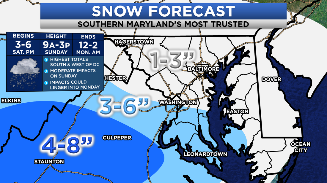
 First Call on Snowfall for the weekend storm. Next Chance of Accumulating Snow: Saturday Afternoon into Sunday Probability of Accumulating Snow: 95% Snow chances continue to become more solidified for the Mid-Atlantic. Impactful snow looks to strike the area this weekend, with the bulk of the highest totals focused south and west of DC. Areas in Southern Maryland and Central Virginia should be able to squeeze some decent amounts. Impacts could linger into the day on Monday. Snow could start flying across the Mid-Atlantic as early as Saturday as the first initial wave of snow moves through. The northern branch of this storm looks to race out ahead of the "parent" storm down south. As it does so, light snow will break out across northern areas. This is largely where they will see a large chunk of their snow. I am not expecting much snow in Southern Maryland on Saturday, as we look to be too far south for those impacts. 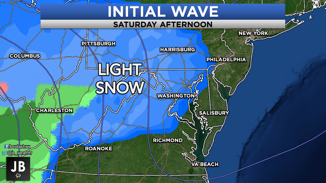 As that northern stream wave moves off the coast, that "parent" southern storm will take aim. The storm will move across the Carolina's and off the East Coast on Sunday. With the storm placed just off the Carolina coast, it will tap into Atlantic moisture and throw it into the Mid-Altantic. A strong and cold area of high pressure to our north will lock in the cold air, ensuring this stays all snow for Southern Maryland. Shown below is a snapshot of Sunday afternoon, when conditions could be at their height. 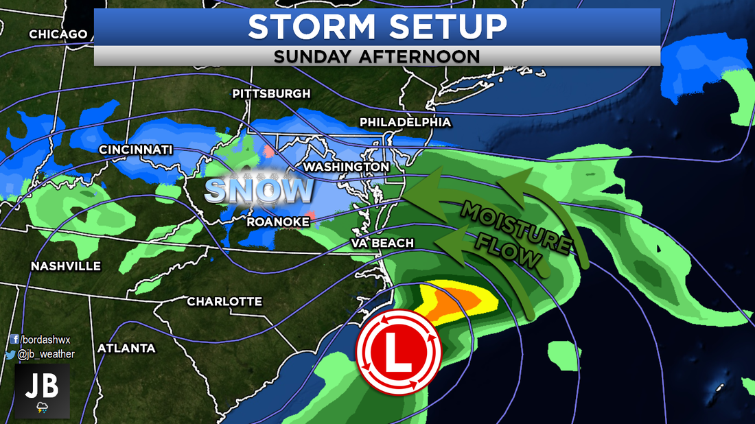 The southern storm will focus most of its impacts in areas south of DC. Moderate snow could fall, allowing for decent accumulations. It is important to note, the Southern Maryland snow forecast is largely dependent on this southern storm. If this storm stays a tad more suppressed to the south, or is not as strong, totals could be lowered. On the same token, if this storm comes a touch to the north, or is stronger, totals could be a hair higher. These are details we should iron out over the next couple of days. We will begin to see impacts from this second storm Saturday night into Sunday morning. With temperatures in the lower 30s, this should be all snow. As the afternoon wears on, snow will start to become moderate. If this storm is stronger, we could see the heaviest snows fall Sunday afternoon into the evening. Nevertheless, this storm should move away Sunday night into Monday. By sunrise on Monday, the snow should be over. Shown below is the storm forecast. 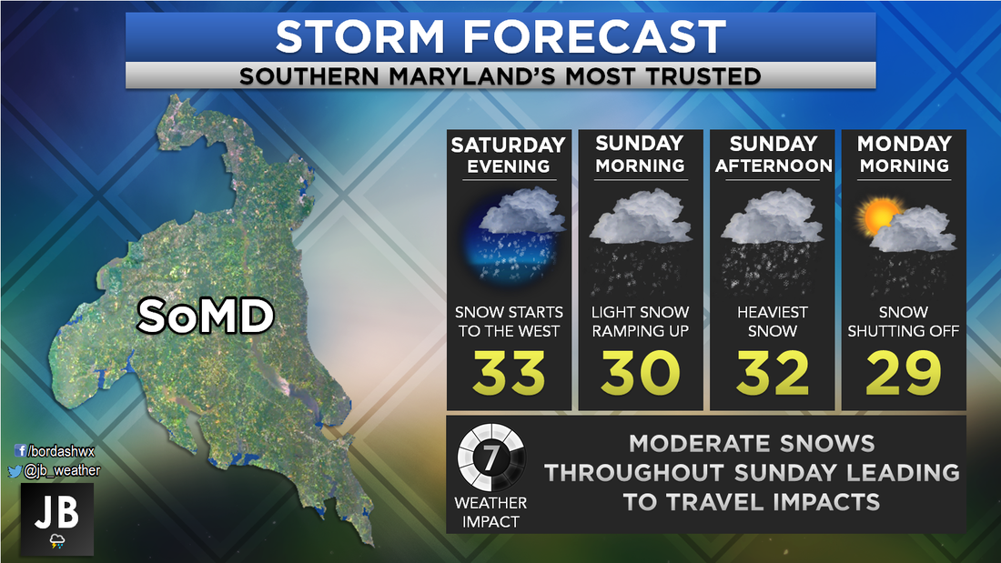 This should be a decent event for our region. Moderate impacts, largely with travel, are likely on Sunday. Depending on that exact track with the second storm, we could see impacts linger into Monday. Yes, that does mean schools and business could be effected on Monday. It is far too early to say what will happen with school impacts. However, I will say that delays could be possible. I will have school odds out on Sunday for Monday. Shown below is a look at where we stand with our storm. A decent 3-6" looks likely. Without the southern storm being as potent, it is possible we don't see as much snow. 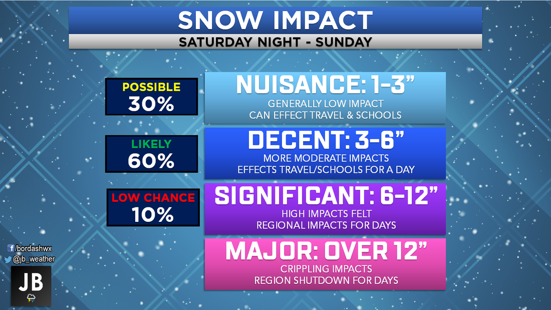 It looks like Southern Maryland is game on for some snow on Sunday! While this is not a storm where you will need to stock the pantry, it will be an appreciable event. There are still some uncertainties in regard to exact track and strength of the storm. We will iron those questions out tomorrow night, so you will want to stay tuned. I will have continuous updates and coverage on Facebook and Twitter. Keep it locked in with Southern Maryland's Most Accurate Forecaster.
Lead Forecaster -John A. Bordash
1 Comment
Leave a Reply. |
Archives
August 2020
Categories
All
|
 RSS Feed
