
 First Call on snowfall from Thursday night through Friday morning. Next Chance of Accumulating Snow: Thursday Night - Friday Morning Probability of Accumulating Snow (1" or more): 50% It looks Winter is finally coming to an end for Southern Maryland. I think this week will be our last real shot of cold air as well as our last winter weather threat. However, before we leap into Spring, there is, what appears to be, our last winter weather threat for late this week. Just 36 hours out, there is a bit of uncertainty with this forecast. What we do know is that we will be dealing with two systems. There will be an initial weak area of low pressure, referred to as a clipper, that will track from the Mid-West into the Ohio River Valley, Thursday into Thursday evening. As that weak storm moves into the Ohio River Valley, a surge of moisture will overspread the area after rush hour, and that should be mainly rain. However, it looks like that surge of moisture may be able to end as a period of snow. That "clipper" will die off, and a new area of low pressure will develop along the coast early Friday morning What we don't know is how that second area of low pressure, that will develop along the coast, will track. Initially, it had appeared that the coastal storm would stay far enough out to sea, which would mean that any snow accumulation would come from the weak clipper. However, recent weather guidance has brought that coastal storm a bit closer to the coast, which would be mean the chance of higher totals. Below, I have drawn the area that I think has the highest chance to exceed my forecasted amounts. What are the chances that our area sees more snow? I'd give it a 50/50 shot. I will have a better idea on this possibility by tomorrow, but the latest trends have been for more snow. 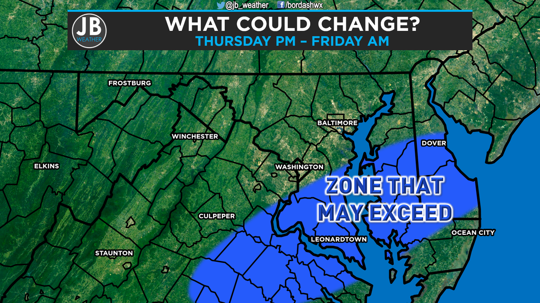 Impacts for our region will not be high, but will be very dependent on how much we see. If that coastal storm takes a path closer to the coast, we would likely have a few delays and closings, and travel would be difficult Friday morning as the peak of the snow would be 3am - 9am. However, if the coastal storm stays further out to sea, impacts would be very minimal as we would only see up to 1" on grassy areas. Right now, my forecast takes into account the "clipper" and some snow from the coastal storm.  The Bottom Line is to expect at least a little bit of winter weather late Thursday night into Friday morning. Rain should overspread the area after Thursday's evening rush hour, and should change to snow as the weak area of low pressure dies off. A developing coastal storm may come close enough to brush us with some more snow Friday morning. There is some disagreement with how close this system gets. The closer to us this gets, higher the snow totals. Expect some impacts Friday morning, but I'm not sure how many delays and closings there will be. It's hard to accumulate snow this time of year. I will have a much better idea of how things should play out tomorrow, so stay tuned!
Lead Forecaster -John Bordash
0 Comments
Leave a Reply. |
Archives
August 2020
Categories
All
|
 RSS Feed
