
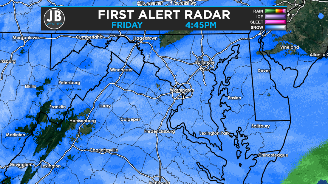
 Radar as of 4:45pm, Friday. As of 4:45pm, here's where we stand right now with the Blizzard of 2016. Light to Moderate snow is falling across the region, and has been doing so since around noon today. Great call by the school districts to close today. As of 4:40, I have recorded 2.5" inches in Solomons, MD.
Temperatures are lower than originally thought. What does this mean? Well it means two things that are very important. Firstly, that means that more snow is able to fall and accumulate. After 2-3 hours of snow, most already reported 1-2" of snow. I'm sure those totals are way higher now. I expect for this to continue throughout the day. It's for this reason alone that it looks like our updated forecast should verify. Secondly, this means that it will take longer for temperatures to get to the point for mixing to occur, and when it does occur, it shouldn't last for too long, maybe just a few hours. It's for this reason that snow totals could be on the higher side of our ranges The Storm Track looks to be further south than I had expected. Our new area of low pressure is forming off the South Carolina/Georgia border, when I had expected it off the South Carolina/North Carolina border. What does this mean? This will allow our already colder than forecasted temperatures to stick around. This also means that the mixing line may not be as far north as thought. Having this further south storm track is good news for snow lovers. This by no means signifies that we'll get the heaviest snow, but it does mean that we could see some more snow. Additionally, this storm track could mean that the winds may not be as high, but could still be above 35mph. The Bottom Line is that things are working in favor for snow lovers right now. The temperatures are cold than thought, and the storm is tracking further south. Expect for the snow to continue, and increase in intensity, throughout the night. If we're going to mix with sleet or rain, it would be between 3am and 10am Saturday. However, some areas in SoMD (Huntingtown, La Plata, Lower Marlboro) may never mix. We are still expecting blizzard conditions, but the winds may not be as high as once feared. Power Outages are still possible, if not likely. Tomorrow midday and early afternoon will feature the heaviest snow for SoMD of the whole storm. The earlier arrival means that snow should leave later, and I'm thinking the snow tapers off between 5pm and 12pm Saturday. Our final forecast was for 12-18" south of Route 231, and 18-24" north of there. We're not changing our forecast, but totals could definitely be on the higher side of those ranges, and might exceed them. Stay off the roads, and inside. Snow removal personnel, SMECO crews, and emergency personnel do not need to worry about navigating around us to do their job. This storm looks to be a top 2 all-time snowstorm. Stay with JB Weather for continuing coverage. Lead Forecaster -John Bordash
2 Comments
Claudia Garrett
1/22/2016 06:05:11 pm
I'm surprised that there wasn't a public service spot on how to locate the closest warming center in case of a power outage. People I talk to seem to think its the nearest public school.
Julie
1/22/2016 06:51:46 pm
I know there is a program in place for the homeless. It is called The Warm Program. Each night a local church takes them in. This weekend I am sure that one Church will be keeping them for the weekend. They are given cots, warm blankets, pillows, and food. a few church members stay the duration as well as the local police because it is open to men, womem, and children. Leave a Reply. |
Archives
August 2020
Categories
All
|
 RSS Feed
