
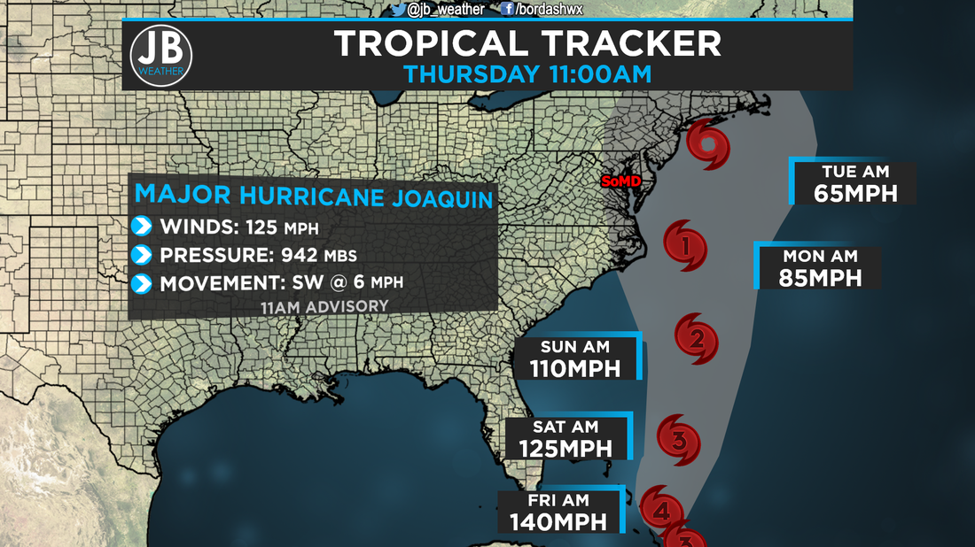
 11am Advisory from the National Hurricane Center on Joaquin I will preface this with: this will not be a long a post as I'm writing this in between classes, but wanted to get something out. Expect a longer, more detailed, post this afternoon. Major Hurricane Joaquin Late last night, Joaquin continued to rapidly strengthen, and is now classified as a Major Hurricane. The storm currently sits near the Bahamas, and is not really moving all that fast. Hurricane Warnings are now in effect for the Bahama Islands. Last night's model runs caught on to something that was not really looked at as a high possibility, the out to sea track. Over the past couple of days, almost every model we look at with tropical weather, including one of our two major models, the American Model, showed Joaquin tacking up and in to the coast. While most our models showed this scenario, the European, the second major model we look at, has continued to show an out to sea track. We weren't putting much faith in the European, as every other model showed another track, and considered it an outlier. Well, last night, the American model started to trend towards the European. In yesterday's blog post I detailed how this storm would go out to sea. Right now, the storm is continuing to get pushed southwest from Ida's Remnants. If Joaquin continues to go southwest this evening, the chance of an out to sea track goes up dramatically. The National Hurricane Center's latest forecast cone now show a shift to the east, but the track they show is unlikely. This storm will either come up and into the Mid-Atlantic, or out to sea. I see no real way this goes straight up the coast. So, what do I now think will happen? My thoughts have changed, and below are scenarios: SCENARIO A (50%) MID ATLANTIC LANDFALL This is the worse case scenario. How does this scenario play out? The storm gets pulled north by the Jet Stream, and flung into the coastline from the strong high. With this, landfall could be anywhere from Southern New Jersey to Cape Hatteras, North Carolina. What would this mean for us? Well, I'll go in the middle with a Virginia Beach landfall as a Category 1 storm, and here are the impacts:
SCENARIO B (50%) OUT TO SEA This scenario is the best case one. How does this scenario play out? The storm interacts too much the remnants of Ida, continues to move southwest over the next 18 hours, and gets "ejected" out to sea by the Jet Stream. With this, it would be as if Joaquin had never even formed in terms of impacts here. What would this mean for us? Here are the impacts:
Conclusion
Needless to say that things are getting really difficult, but we may have found a way out of a serious situation. However, I will not write off a Mid-Atlantic landfall, it would be irresponsible to do so. I still think a Mid-Atlantic landfall is still a real possibility. It is important to note that the chance of an out to sea track is rising. Again, I will have a more detailed post this afternoon after the 5pm advisory from the National Hurricane, but I need to get off to class now. Stay tuned to JB Weather for the latest information on Joaquin. Lead Forecaster -John Bordash
0 Comments
Leave a Reply. |
Archives
August 2020
Categories
All
|
 RSS Feed
