
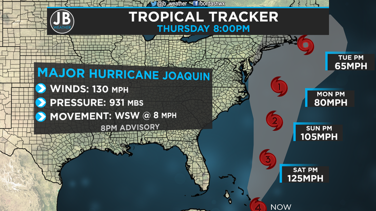
 8PM Advisory on Joaquin from the National Hurricane Center Nobody ever said that forecast with Joaquin would be easy, and it has proven that it won't be. So much has been coming in over the past 24 hours, and we're beginning to get a better idea about the storm. However, this forecast still have low confidence. Joaquin Right Now Major Hurricane Joaquin is currently a monster Category 4 storm, that is raking havoc in the Bahamas. Joaquin is actually the strongest storm in the Atlantic since Igor in September of 2010. Hurricane Warnings have been in place for the Bahamas for a couple of days now. As I have discussed in previous posts, the remnants of former Hurricane Ida have been the major driving forecast of the short term forecast, which then effects the long term. Major Hurricane Joaquin is continuing to push further southwest, as shown above in the 8pm Advisory from the National Hurricane Center. This continued southwesterly push has potential to be good news for us. Joaquin's Forecast Needless to say, this forecast has been hectic. However, I've always said that we need to keep all scenarios on the table, and even tonight I will continue to say that. The weather models we look at have had Joaquin's intensity forecast off for the most part, so it's been hard to put much faith into their track forecast. Nevertheless, almost every model we look at with tropical weather, including one of our two major models, the American Model, showed Joaquin tacking up and in to the coast over the past few days. While most our models showed this scenario, the European, the second major model we look at, has continued to show an out to sea track. We weren't putting much faith in the European, as every other model showed another track, and considered it an outlier. Well, last night, the American model, along with a few others, started to trend towards the European. Now that Joaquin has continued to move more southwest than forecasted, it's beginning to appear that the European may be correct. Now, I'm not going to outright advertise an out to sea track. This storm will either come up and in to the Mid-Atlantic coast, or out to sea. There is not much of a middle ground. Below are my scenarios based off of what I've seen tonight. SCENARIO A (40%) MID ATLANTIC LANDFALL This is the worse case scenario. Keep in mid that the chance of this happening is starting to go down, but it is far from 0%. How does this scenario play out? The storm gets pulled north by the Jet Stream, and flung into the coastline from the strong high. With this, landfall could be anywhere from Southern New Jersey to Cape Hatteras, North Carolina. What would this mean for us? Well, I'll go in the middle with a Virginia Beach landfall as a Category 1 storm, and here are the impacts:
SCENARIO B (60%) OUT TO SEA This scenario is the best case one. This scenario's chances are becoming more likely, due to the continued southward progression, but this is can not be solely advertised this solution. How does this scenario play out? The storm interacts too much the remnants of Ida, continues to move southwest over the next 12 hours, and gets "ejected" out to sea by the Jet Stream. With this, it would be as if Joaquin had never even formed in terms of impacts here. What would this mean for us? Here are the impacts:
Putting it all Together
It is needless to say that things are difficult with this forecast, but we may have found a way out of a dangerous situation. However, I will not write off a Mid-Atlantic landfall, it would be irresponsible to do so. I still think a Mid-Atlantic landfall is still a real possibility. This storm will need to start moving north tonight to give us an impact. Additionally, I do not think that the current forecast track is not realistic. This storm will either move up and into the coast, or out to sea. I've said before that we will know more by tonight, and we do, the chance of an out to sea track is rising. Friday will be the day to confirm one scenario. Stay with JB Weather on Twitter, Facebook, and right here on our website, for the latest on this storm. I may do another video update tomorrow. Stay tuned. Lead Forecaster -John Bordash
0 Comments
Leave a Reply. |
Archives
August 2020
Categories
All
|
 RSS Feed
