
|
GOVERNOR HOGAN HAS DECLARED A STATE OF EMERGENCY FOR MARYLAND
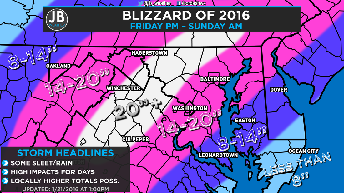
Not just a major, but a crippling winter storm is approaching. Please take this potentially dangerous storm seriously. Snow will start between mid and late-afternoon Friday, and the evening commute on Friday will likely be impacted, so take precautions accordingly. Slowly through the afternoon and early evening the snow will accumulate. But the bulk of the storm's fury will come after dark and throughout Saturday when snow rates could be over 1-3 inches per hour. It does also appear that sleet, freezing rain, and rain will mix in across our region, which will effect snow totals. However, the latest afternoon runs of the models are suggesting not as many mixing problems as once feared this morning. Snowfall intensity will diminish Saturday afternoon, slowly. But breezes will pickup, creating cold wind-chilled air. The impact of this storm will be felt for a long time after snow ceases by early Sunday morning. The National Weather Service has gone ahead and issued a BLIZZARD WARNING from the I-95 corridor, west to the Bay, including all of Southern MD. Elsewhere, there are Winter Storm Warnings (pink) and Winter Weather Advisories (purple) up for locations across the Mid-Atlantic. The Blizzard Warning does mean that in addition to the wintry weather, we will also see high wind gusts over 35mph for three or more hours. 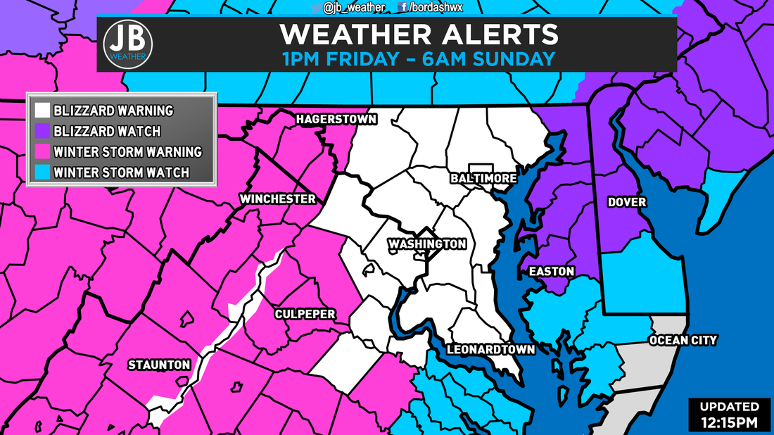 Winter Weather Alerts across the Mid-Atlantic as of 12:15pm. Impact across the region will be high. Travel will be very difficult Friday night through Sunday Morning. DO NOT DRIVE unless absolutely necessary. If you do travel, know that you could be putting your life at risk. Also be courteous of emergency vehicles and snow plows needing right of passage. Flying in/out of D.C. or Baltimore? Airports will likely be forced to close Friday night through Saturday evening. Normal service could take a few days to restore. While I'm not putting out any official school odds for any day other than Friday, expect multi-day school closures next week along with business and the government being forced to close. Below is a new map I will be using to show travel and school impacts. 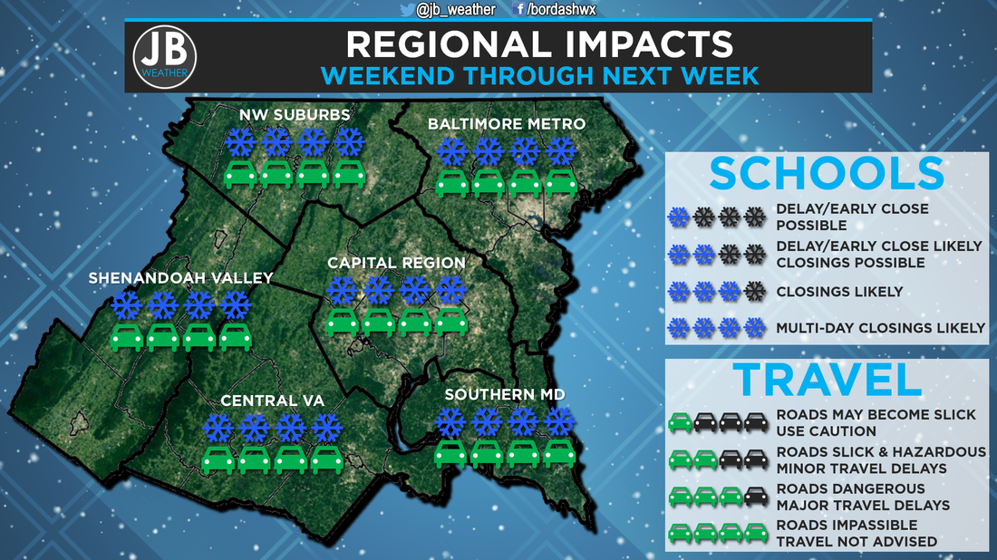 Winter Storm Impacts through next week. What about School Odds for Friday? Even though the storm may be coming in later, I do not think that schools will want to risk a repeat of yesterday's travel problems across the DMV. But, schools could try to get in as much "learning time" (I use that lightly because not much learning will be happening) before the Blizzard. Some school systems may announce tonight, but some may wait until tomorrow morning. I will have updates on school statues tonight and all day tomorrow (if needed). Nevertheless, below are my school odds. 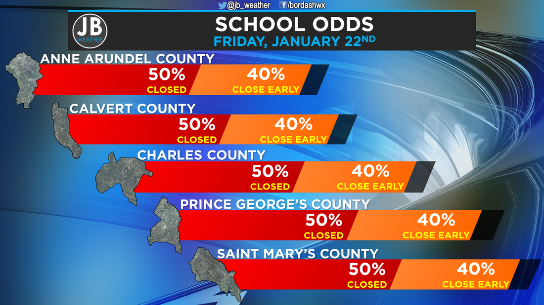 Friday School Odds for southern MD school systems. The Bottom Line is that this is looking like more and more of a crippling winter storm for the Mid-Atlantic. 8-14"+ can be expect across the region along with some sleet and freezing rain. This storm will close everything down for days. The later in the day you head through Friday, the more likely you are to encounter impacts. It looks like the storm should be arriving between 1 and 5pm Friday afternoon. Power outages are possible, if not likely. Have a plan ready to go if you lose power, because you could be without it for days. And of course, stay with JB Weather for accurate reporting on Southern Maryland weather, and how it will affect you. You can get updates here, on Facebook, or on Twitter.
Lead Forecaster -John Bordash
14 Comments
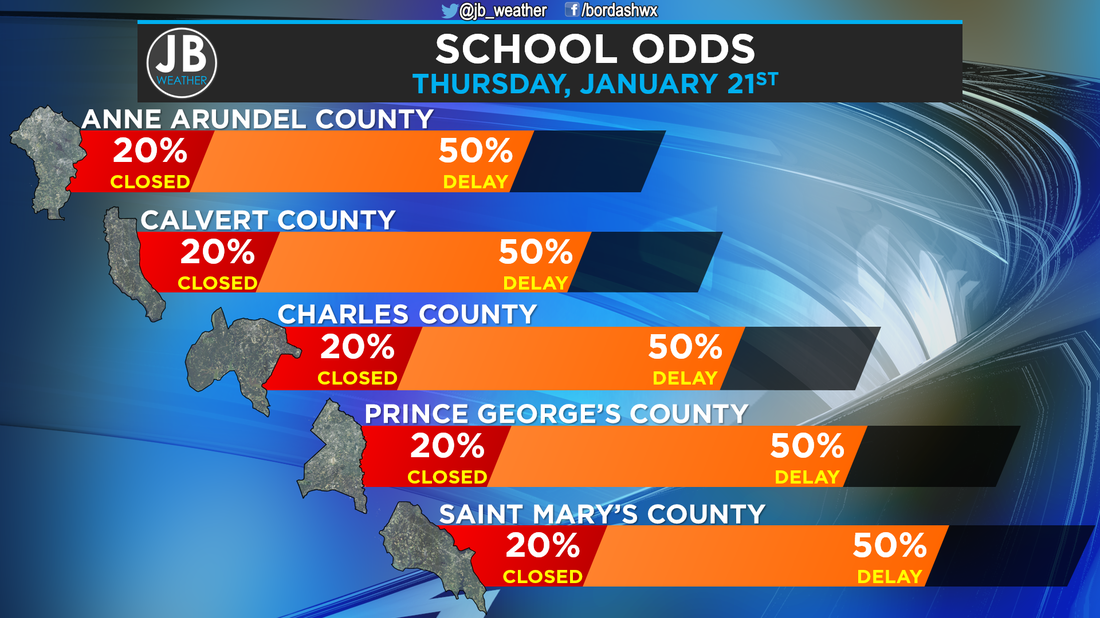 All week I have been talking about the chance of flurries for this evening with a weak system moving through the region. Well, it appears that this event has definitely overperformed. Very few roads, if any, were treated today, and road temps are well below freezing. Even though we only saw 1-2" of snow for most, everything has stuck, and we are looking at some problems region wide. I think that schools may have to opt to delay the day before our massive blizzard comes in. There is even the outside chance of a closure. Below is the debut of a new map here at JB Weather to show what to expect region wide. 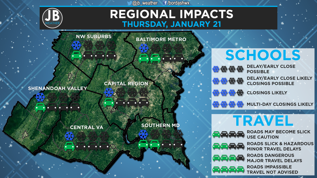 Stay with JB Weather, I will be up at 4am to report on any school calls. Stay safe, and keep in locked with JB Weather for winter weather coverage you can count on
Lead Forecaster -John Bordash |
Archives
August 2020
Categories
All
|
 RSS Feed
