
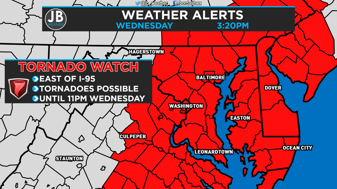
 The Storm Prediction Center in Norman, OK has issued a TORNADO WATCH for Southern Maryland, and areas east of I-95. This watch is in effect until 11PM Wednesday.
Primary threats this evening are:
SUMMARY: Ongoing strong to severe storms over part of east central and western North Carolina should progress northeastward into the evening hours. These storms could also bring the threats for tornadoes and damaging wind gusts. PRECAUTIONARY/PREPAREDNESS ACTIONS: Remember, a Tornado WATCH just means conditions are favorable for tornadoes and severe thunderstorms to develop, nothing is occurring right now. People in the watch area should be on the lookout for threatening weather conditions and listen for later statements and possible warnings if severe weather or tornadoes are imminent. Stay with JB Weather for continuing coverage on Southern Maryland severe weather. Lead Forecaster -John Bordash
0 Comments
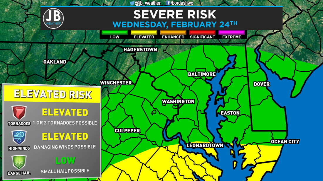 Severe Risk map from the Storm Prediction Center for Wednesday, Feb. 24, 2016. The set-up for Wednesday looks to hold an elevated risk of strong to severe storms, along with a heavy rain threat. The severe threat will be dependent on how unstable, or warm, we get. The Flood threat seems to be much more likely at this point. Generally speaking, this is a setup I try not to get too excited about as a forecaster. Cloud cover and rain stabilize the atmosphere, which can limit the severe weather threat. The game we get to play tomorrow is: how unstable can we get the atmosphere? However, there have been plenty of times where we have been able to get some wicked storms with all day cloud cover and mist. The Severe Threat for tomorrow will be caused by an area of low pressure moving northward through the Mid-West. This storm system could actually give areas across Indiana and Michigan a decent sized snowstorm. However, we will not being deal with any wintry weather from this storm. As it pushes north, it will allow for temperatures to potentially soar into the 60s tomorrow afternoon and evening. Tomorrow may be a day where the actual high occurs around 7/8pm. Temps tomorrow will be dependent on how much cloud cover and rain we see throughout the day. The soaring temps will be due to the winds coming from the south. The winds above our heads will be racing. Those high winds aloft can help to create severe weather, and damaging winds within storms. However, we will not have too much energy, or what is referred to as CAPE, in the atmosphere to work with. This is called a "High shear, low CAPE" set up in the weather world. Below is our North American Model simulated radar for tomorrow evening. Don't take the simulated radar verbatim with storm placement and exact timing, but it does give us a few take aways. A few rain showers can be expected throughout the day. It looks like our threat for severe storms exists between 6pm and 12am as a line of storms works through. I think the model above may be just a tad too slow with moving that long through.
Because the atmosphere will be juiced up with moisture it appears that heavy rain, that could lead to flooding, will be our primary threat along with high winds. This set up also tells me that there is an elevated tornado threat, but the threat isn't too high. The better chance of tornadoes will be to our south, across southern Virginia and North Carolina. The Bottom Line is that some thunderstorms are possible tomorrow evening between 6pm and 12am. Heavy rain and high winds are the main threats with any storms that move through. There is also an elevated tornado threat, but it is not my primary concern. We will have rain showers and cloud cover throughout the day, which could help to prohibit the severe weather development. The Storm Prediction Center currently has portions of our region under an elevated risk for severe storms. However, I expect for them to place all of Southern Maryland under an elevated risk, tomorrow. You're going to want to stay with JB Weather for the latest forecasts and coverage if we do see storms tomorrow evening. Lead Forecaster -John Bordash
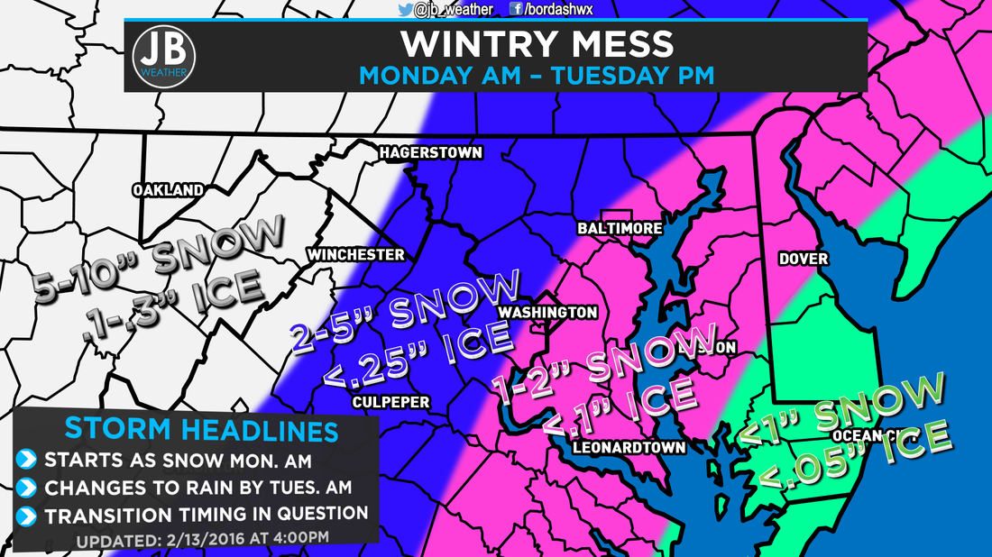
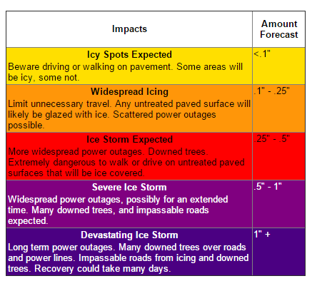
Things have come into focus a bit more since yesterday's forecast, and we now have a better idea of what will likely happen. As I advertised yesterday, this will not a big snowstorm nor will it be a big ice storm. This is the first time this season that we will have to worry about a threat of ice, but it is not a big threat here in Southern MD. For a quick summary, skip down to "The Bottom Line" paragraph. We are actually going to be looking at three different areas of low pressure that will all work to give the Mid-Atlantic snow/sleet/freezing rain/rain. The first area of low pressure will move in overnight. It's a small system that is normally referred to as a clipper. Instead of merging with the main storm system, it will run out ahead of it, and start to have snow break out tonight, after sundown and likely around midnight. It is this small system that will give us the majority of our snowfall as we will not be looking at ice from it. What ever falls overnight and tomorrow morning will stick right away as ground temperatures are in the lower teens and actual air temps will be between 12-18. Thus, roads could be snow covered by the morning rush. Dry air might be an issue once precipitation starts showing up on Radar, so it will take time to actually get snow down to the ground. Once that small "clipper" system moves out, our main storm system will take over, or the second low pressure. It is completely possible there is a time late tomorrow morning or early tomorrow afternoon where nothing is falling as one system moves out and the other takes over. Nevertheless, temperatures will still be cold enough late tomorrow morning to support snow, so anything that falls will be likely be white. As the system starts to move north, it will bring in some warmer air. It will warm the upper atmosphere first, before the "surface" where we live. This means that after lunchtime Monday, we will start to mix with sleet and eventually freezing rain. It's during this time that we could see some minor ice accumulation. As the surface starts to warm, we should switch over to all rain. This change over will gradually happen from southeast to northwest, so areas northwest of I95 will take longer to switch over, but will eventually do so too. Rain is likely throughout Monday evening into Tuesday afternoon. Some flooding could be possible as we could see up to 1" of rain. The third, and last, low pressure system we might have to deal with is another small clipper system early Wednesday morning. Right now, it looks rather weak and temperatures look a tad too warm for much more than rain. Nevertheless, it is something to watch, and if it were to bring snow, it would be light with minor amounts. Not expecting too much from that. 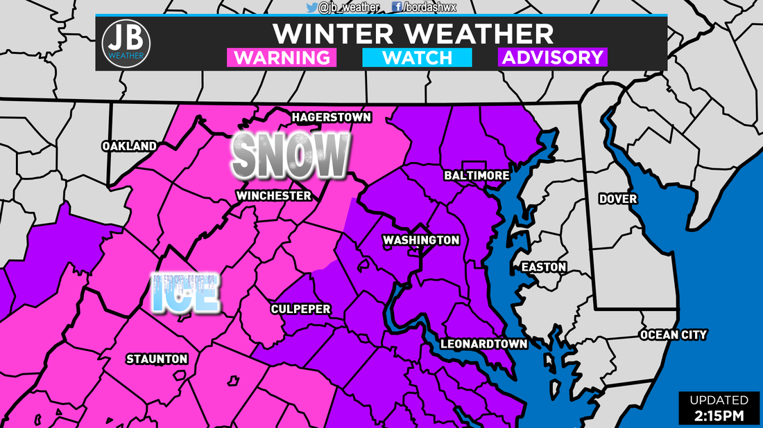 Winter Weather Alerts as of 2:15 Sunday afternoon. The National Weather Service has issued Winter Storm Warnings (pink areas) and Winter Weather Advisories (purple areas) for a large swath of the Mid-Atlantic. Those under the Warnings will see higher snow and ice accumulation totals. It will take longer for these locations to switch from snow to ice, and then from ice to rain. Power Outages are possible and travel is not advised. For the Advisory areas, there will be lesser amounts of snow and ice, but there will still be travel difficulties as well as the outside chance of power outages. For those who have school or work on Monday, I fully expect those places to be closed. Snow covered roads by the morning, along with a transition to ice, will make commuting difficult. It is still too early to make a call on Tuesday, but delays/closings will be dependent on how late the snow/ice stick around on Monday. I'll have school odds for Tuesday up tomorrow afternoon.
 The Bottom Line is that snow will move into the region overnight tonight which will switch over to icy mix after lunchtime, and will be all rain by Monday evening. This will not be a big snow or ice storm, but the snow and ice on Monday will be disruptive. Roads could be snow covered as early as sunrise Monday, so travel is not advised. Any schools or business that are scheduled to be open on Monday will likely be closed. It is still too early to say what will be opened on Tuesday. I have pretty good confidence in this forecast. If temperatures are cooler than expected and dry air isn't an issue, snow/ice totals could be higher, if they are an issue, totals could lower. Nevertheless, I like where my forecast stands. I will have coverage all day tomorrow. Stay with JB Weather for the latest on Southern Maryland weather.
Lead Forecaster -John Bordash
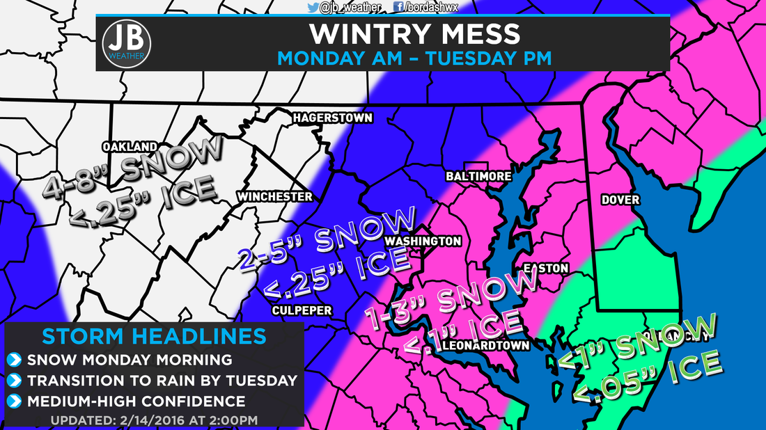
Next Chance of Accumulating Snow: Monday Probability of Accumulating Snow (1" or more): 60% Another wintry event is poised to strike the Mid-Atlantic, but this one will be just a bit different than other storms we've had to deal with so far this winter. Most of our storms have either been snow or rain with the concern of ice being virtually absent. Well, all good things must come to an end, and we're now tracking a storm that may bring an icy mix to Southern MD. Our cold air sets the stage for this storm. We're are going to be really cold this weekend. Temperatures have failed to go above 32 since Thursday, and lows tonight will be plunging into the single digits. This storm system will be coming as our cold air starts to move out. However, it is really hard to just displace cold air out of our region. As a result, shallow cold air (relative to the atmosphere) can get trapped here at the surface while the air above us is warming. When this happens, we have to start worrying about sleet and freezing rain, which can lead to ice accumulations. It appears that precipitation will start to breakout during the predawn hours of Monday morning as our storm pushes north. Temperatures will be in the 20s and upper teens, so whatever falls will be in the form of snow. The atmosphere will be cold enough to support snow until the afternoon hours of Monday. It's at that time that the upper levels of the atmosphere start to warm, and we will start to mix with sleet and eventually freezing rain from southeast to northwest. We will dealing with this wintry battle until the early morning hours of Tuesday. By then, the atmosphere should be "warm" enough to support plain rain, and we'd deal with rain until the afternoon on Tuesday. Temperatures Tuesday may max out in the upper 40s and lower 50s. I'm skeptical of how warm we get and how fast. It's very hard to dramatically warm temperatures during the nighttime hours while it's precipitating. Nevertheless, we will change to plain rain eventually. The further inland you are, the longer you will see wintry precipitation. It is for that reason that the National Weather Service has issued a Winter Storm WATCH for areas along, and west, of I95 where more snow and ice is possible. We will still have to deal with snow and ice southeast of I95, but not as much, hence why we are not under a Watch right now.  Winter Storm Watches as of mid-afternoon Saturday. These are set to take effect at 1am Monday, and last until 10am Tuesday. I am aware that many schools and business are closed on Monday for President's Day, but there are few places, including the College of Southern Maryland, that are scheduled to be open in full capacity. For those traveling or heading into work/school on Monday, I'd make an early call and say that those places will likely be closed, and travel could be impacted. Impacts may linger into Tuesday, but that will all be dependent on how long it takes for the wintry weather to transition over to rain. I am also tracking a small system that looks to move in behind this storm Tuesday night into Wednesday morning. It is still too early to speculate on that storm, but stay tuned.
 The Bottom Line is that we will have snow across the region Monday morning into Monday afternoon that will transition over to an Icy mix Monday evening, and eventually all rain by Tuesday morning. Any schools or business that are scheduled to be open on Monday will likely be closed and travel will be impacted. There are still a few questions on where the storm tracks, which then affects our temperatures, so snow/ice amounts have the potential to increase or decrease. RIght now this a medium confidence forecast, but we should know a lot more by this tomorrow, which is when I plan on releasing my final call. I am not expecting this to be a major snowstorm or ice storm. Stay with JB Weather on Facebook and Twitter for the latest information on this potential wintry mess.
Lead Forecaster -John Bordash 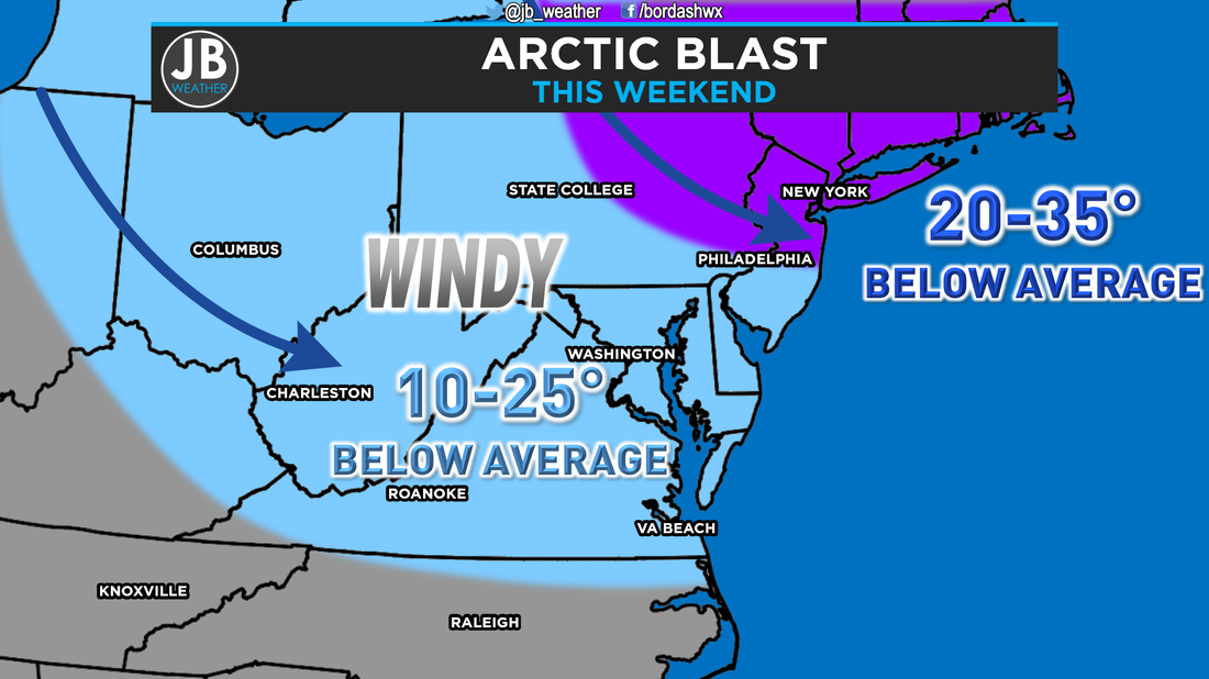 February will definitely live up to to it's reputation as a winter month over the coming days. Not only am I tracking bitter cold on tap for late this week and weekend, but I'm also watching a storm chance for early next week. Cold air moves in tonight on the coattails of some breezy northwest winds. For next 4-5 days, I don't think we see a high on the better side of freezing, and if we do get above freezing, it'll be for an hour or two. It looks like we max out between 30-32 Thursday and Friday. Temperatures on Friday will actually drop throughout the day as a cold front moves through that will usher in even colder air! We stay in the 20s this weekend with Saturday night offering some record cold. Lows in the single digits will challenge many records and the gusty winds will make it feel like we're well below zero. It looks like we do eventually warm up next week, which should be welcomed by many. In my forecasting expiernce, I have learned that when you're dealing with arctic air, there is almost always a snow chance when the cold air moves in and/or when the cold air leaves. We could have some flurries Friday night when the coldest air moves in with the cold front. However, I'm more interested with the potential early next week, when the cold air leaves. 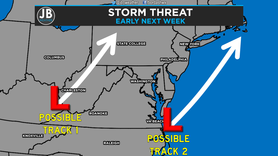 It looks like we'll have a storm heading northeastward somewhere along the east coast between Monday and Wednesday next week. Now I'm still uncertain about the storm track. A track to our northwest, across West Virginia, would be a warmer solution and would favor a mainly rain solution w/ a few snowflakes at the onset. If the storm takes more of a track like the second one, along the coastline, we would be colder and would favor a more wintry solution. I think we'll see a mixture of the two tracks. An initial low pressure system would try to take track 1 but then is forced to form a new low pressure area that follows track 2. Those types of set ups tend to favor at least some type of a wintry solution. It's also really hard to just have entrenched cold air move out of our region, so temps may very well stay in the low 30s Monday and maybe hitting 40 on Tuesday. It's all just speculation at this point, and we won't know details until we get closer to the weekend.
The Bottom Line is that the next few days are going to be extremely cold and as our cold air tries to moves out, we could have a storm to deal with. There are a few unknowns this far out, especially with our storm threat. Don't make any changes to your schedules for early next week yet, but know that there is threat for something early next week. We'll have more details in the coming days. We first need to focus on the bitter cold for late this week and weekend. Stay with JB Weather for the latest Southern Maryland weather forecasts. Lead Forecaster -John Bordash |
Archives
August 2020
Categories
All
|

 RSS Feed
